1940s Maps of Maury County, Tennessee
Explore 11 historic maps of Maury County from the 1940s. These maps offer a rare glimpse into what life looked like during the 1940s — showing old roads, neighborhoods, homes, and landmarks that have changed or disappeared over time.
Whether you're researching your family's past, planning a metal detecting trip, or studying how Maury County's landscape evolved across the 1940s, these high-resolution maps are a powerful tool for exploring the history of this region.
- Focus on a specific era: All maps on this page are from the 1940s, giving you a focused view of this time period.
- See what’s changed: Compare century-old streets, trails, and buildings to today's modern landscape using overlays and satellite layers.
- Research with precision: Use these maps for genealogy, historical research, land use analysis, or educational projects.
- View, download, or print: Maps are fully viewable online in high resolution, and can be downloaded or printed for your own records.
Start exploring Maury County's history through authentic maps from the 1940s. This is your window into the past.
Maury County, TN maps
(11)- 1940 Map of Godwin, 1954 Print
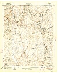
 1940 Godwin1954 Print · USGSMaury County's river-carved landscape is captured here in the mid-twentieth century, featuring the winding Duck River and its many valleys. Researchers can trace family history through sites like Old Knob Creek Cem, Darks Mill, and the Louisville and Nashville rail line.
 - 1941 Map of Godwin
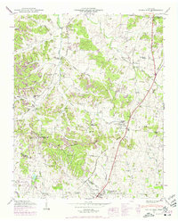
 1941 Godwin1941 Print · USGSMaury County at the start of the 1940s is a landscape of winding river bends and tight-knit rural communities. Researchers can trace family history through numerous landmarks like Old Knob Creek Cem, Darks Mill, and the many country churches.
 - 1941 Map of Carters Creek
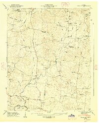
 1941 Carters Creek1941 Print · USGSCentral Tennessee at the start of the 1940s reveals a landscape of rural schoolhouses and family cemeteries along the Andrew Jackson Highway. Trace early mineral industry at the Phosphate Mine or locate ancestral sites like Old Brick Ch and Buford Cem.2 unique versions available
 - 1946 Map of Spring Hill, 1975 Print
 1946 Spring Hill1975 Print · USGSMid-century Middle Tennessee comes into focus as the Louisville and Nashville railroad tracks cut through the hills of Maury and Williamson Counties. Genealogists and historians can trace family plots like Harrison Cem and Patton Cem alongside landmarks such as Thompsons Station and the Mt Laverne School.3 unique versions available
 - 1946 Map of Mount Pleasant, 1987 Print
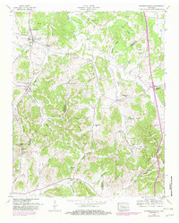
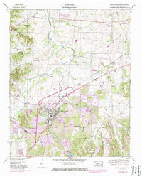 1946 Mount Pleasant1987 Print · USGSMount Pleasant and its surrounding mining districts are captured here during a period of significant industrial expansion. Researchers can trace family-named cemeteries like Arlington Cem and Hunter Cem or explore early industrial sites like the MONSANTO CHEMICAL COMPANY works and local Strip Mines.
 - 1947 Map of Glendale, 1948 Print
 1947 Glendale1948 Print · USGSThe Duck River country of Maury County is captured here just after the war, showing a landscape defined by deep river bends and rural rail stops. Genealogists can locate dozens of family burial sites like Tankersley Cem and trace the Louisville & Nashville tracks through Park Station.6 unique versions available
 - 1947 Map of Rally Hill, 1948 Print
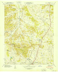
 1947 Rally Hill1948 Print · USGSMid-century Middle Tennessee comes to life in this survey of the Maury and Williamson county line. Genealogists can trace family roots through dozens of sites like Derryberry Cem or visit vanished crossroads like Rally Hill and Lunns Store.4 unique versions available
 - 1947 Map of Verona, 1948 Print
 1947 Verona1948 Print · USGSMarshall and Maury counties in the late 1940s were defined by the winding course of the Duck River and its rural mill seats. Researchers can trace family homesteads near Verona, old burial sites like Lillard Cem, and river landmarks such as Lillard Mill.6 unique versions available
 - 1949 Map of Columbia
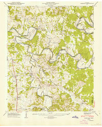
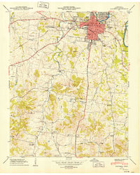 1949 Columbia1949 Print · USGSColumbia is captured here during a period of steady post-war growth along the Duck River and the Bee Line Highway. Researchers can locate vanished landmarks and family sites, from the Columbia Military Academy to rural gems like Rocky Glade Sch and the Ephesus Ch.2 unique versions available
 - 1949 Map of Spring Hill
 1949 Spring Hill1949 Print · USGSSpring Hill and Thompsons Station are shown here in the late 1940s as central hubs for the local rail and road networks. Genealogists can trace family-named sites such as Harrison Cem, West Harpeth School, and McCormack Crossing along the old pike.
 - 1949 Map of Campbells Station, 1982 Print
 1949 Campbells Station1982 Print · USGSMid-century Tennessee hill country comes alive here as the LOUISVILLE AND NASHVILLE railroad winds through the ridges of Maury and Marshall counties. Genealogists and historians can trace family landholdings via dozens of sites like Shahe Cem, Mooresville School, and Dodson Siding.
End of results
Showing maps 1-11 of 11
Top cities of Maury County
Frequently asked questions
- What are the different types of historical maps available for Maury County?
- What is the oldest map of Maury County?
- Where can I purchase historical maps of Maury County for my home or office?
- Where can I download high-res historical maps of Maury County?
- Are there historical topographic maps available for Maury County?
- Is there historical aerial imagery available for Maury County?
- Where are historical maps of Maury County sourced from?