1960s Maps of Maury County, Tennessee
Explore 3 historic maps of Maury County from the 1960s. These maps offer a rare glimpse into what life looked like during the 1960s — showing old roads, neighborhoods, homes, and landmarks that have changed or disappeared over time.
Whether you're researching your family's past, planning a metal detecting trip, or studying how Maury County's landscape evolved across the 1960s, these high-resolution maps are a powerful tool for exploring the history of this region.
- Focus on a specific era: All maps on this page are from the 1960s, giving you a focused view of this time period.
- See what’s changed: Compare century-old streets, trails, and buildings to today's modern landscape using overlays and satellite layers.
- Research with precision: Use these maps for genealogy, historical research, land use analysis, or educational projects.
- View, download, or print: Maps are fully viewable online in high resolution, and can be downloaded or printed for your own records.
Start exploring Maury County's history through authentic maps from the 1960s. This is your window into the past.
Maury County, TN maps
(3)- 1965 Map of Carters Creek, 1967 Print
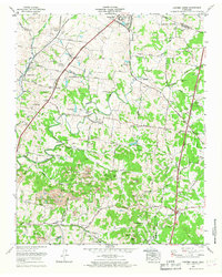 1965 Carters Creek1967 Print · USGSMaury and Williamson Counties are shown here during the mid-1960s, a period defined by established agricultural research and active mining operations. Researchers can trace family history at Meadow Lawn Memorial Garden or locate the Tennessee Orphans Home and Lanton Church.2 unique versions available
 - 1965 Map of Columbia, 1967 Print
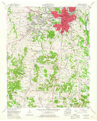 1965 Columbia1967 Print · USGSColumbia and the surrounding Maury County landscape are captured in the mid-1960s as suburban growth began to push south and west. Genealogists and local historians can locate dozens of family burial sites like Zollicoffer Cemetery or trace the old paths of the Louisville and Nashville Railroad and Bighyville Road.4 unique versions available
 - 1965 Map of Godwin, 1967 Print
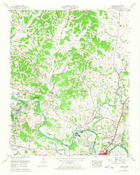 1965 Godwin1967 Print · USGSMaury County at the mid-point of the sixties reveals a transition from traditional rural life to modern residential growth. Genealogists can trace family roots through numerous local landmarks like Harlan Sch, Old Knob Creek Cem, and the community at Santa Fe.3 unique versions available
End of results
Showing maps 1-3 of 3
Top cities of Maury County
Frequently asked questions
- What are the different types of historical maps available for Maury County?
- What is the oldest map of Maury County?
- Where can I purchase historical maps of Maury County for my home or office?
- Where can I download high-res historical maps of Maury County?
- Are there historical topographic maps available for Maury County?
- Is there historical aerial imagery available for Maury County?
- Where are historical maps of Maury County sourced from?