1900s (20th Century) Maps of Maury County, Tennessee
Explore 48 historic maps of Maury County from the 1900s (20th Century). These maps offer a rare glimpse into what life looked like during the 1900s — showing old roads, neighborhoods, homes, and landmarks that have changed or disappeared over time.
Whether you're researching your family's past, planning a metal detecting trip, or studying how Maury County's landscape evolved across the 1900s, these high-resolution maps are a powerful tool for exploring the history of this region.
- Focus on a specific era: All maps on this page are from the 1900s, giving you a focused view of this time period.
- See what’s changed: Compare century-old streets, trails, and buildings to today's modern landscape using overlays and satellite layers.
- Research with precision: Use these maps for genealogy, historical research, land use analysis, or educational projects.
- View, download, or print: Maps are fully viewable online in high resolution, and can be downloaded or printed for your own records.
Start exploring Maury County's history through authentic maps from the 1900s. This is your window into the past.
Maury County, TN maps
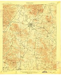
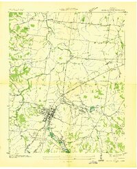
(48)- 1901 Map of Colombia
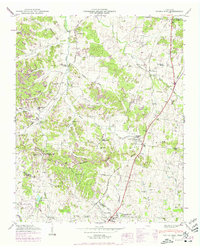
 1901 Colombia1901 Print · USGSMiddle Tennessee at the close of the century reveals a landscape shaped by river bends and a dense network of turnpikes. Genealogists can trace family roots through settlements like Santa Fe and Warner or locate landmarks such as the U.S. Arsenal and Zion Ch.3 unique versions available
 - 1909 Map of Franklin
 1909 Franklin1909 Print · USGSWilliamson County at the start of the twentieth century remains a landscape of historic pikes and rail-side villages. Genealogists can locate family homesteads near landmarks like Thompsons Station, Leipers Fork, and the Boiling Spring Academy.2 unique versions available
 - 1936 Map of Godwin
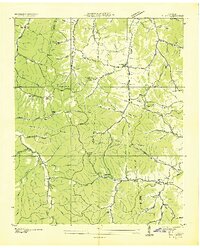
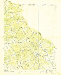
 1936 Godwin1936 Print · USGSMaury County life in the mid-1930s is captured here, showing a landscape defined by the winding Duck River and local rail lines. Genealogists can locate family landmarks like Timmons Cem, the settlement at Darks Mill, and rural schools including Santa Fe Sch.
 - 1936 Map of Sandy Hook
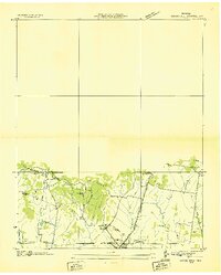
 1936 Sandy Hook1936 Print · USGSThe rural borders of Maury and Giles counties are captured in the mid-thirties as a landscape of small ridges and rail-connected hamlets. Genealogists can trace family names and local landmarks like Scotts Mill, Jonestown, and Ettaton Sch before modern development changed these hills.
 - 1936 Map of Williamsport
 1936 Williamsport1936 Print · USGSMaury County's river valleys and phosphate industry are detailed in this mid-1930s survey of the region surrounding the Williamsport settlement. Genealogists can trace family landmarks and rural life through Zion Chapel, Jones Cem, and the Armour Phosphate Co works.
 - 1936 Map of Primm
 1936 Primm1936 Print · USGSThe rural borders of Maury, Hickman, and Williamson counties are captured here in the mid-1930s as the TVA began modernizing the landscape. Researchers can trace family history through local landmarks like Johnsons Mill, Elmo Sch, and the Warf Cem.
 - 1936 Map of Mt Joy
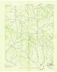
 1936 Mt Joy1936 Print · USGSThe rural borderlands of Lewis and Maury counties are captured here in the mid-1930s as a landscape of small crossroads and family farms. Researchers can trace ancestral roots through numerous local landmarks like Willis Chapel, Dixon Spring Cem, and Macedonia Sch.
 - 1936 Map of Verona
 1936 Verona1936 Print · USGSMarshall County rural life in the thirties followed the winding loops of the Duck River and the tracks of the Louisville and Nashville railroad. Genealogists can locate family landmarks like Bethlehem Cem, Hardison Mill, and the community at Verona.
 - 1936 Map of Campbells Station
 1936 Campbells Station1936 Print · USGSThe rural borderlands of Maury, Marshall, and Giles counties come into focus during the mid-thirties, centered on the Louisville and Nashville rail line. Researchers can trace old family sites and rural centers like Campbells Station, the Ballamfant Cem, and Mooresville Sch.
 - 1936 Map of Crestview
 1936 Crestview1936 Print · USGSThe Lawrence County highlands in the mid-1930s reveal a landscape shaped by the Louisville and Nashville Railroad and early rural electrification. Local historians can trace family roots through landmarks like Porter Chapel Sch, Pleasant Garden Ch, and the settlement of Rockdale.
 - 1936 Map of Rally Hill
 1936 Rally Hill1936 Print · USGSThe rural borders of Maury, Williamson, and Marshall counties are shown here during the mid-1930s, featuring a landscape of small family farms and tight-knit crossroads. Researchers can locate vanished community anchors like the Lee Buckner School, Lees Corner, and Hargrove Cemetery.
 - 1936 Map of Spring Hill
 1936 Spring Hill1936 Print · USGSThe Tennessee and Maury county line area is captured here in the mid-1930s as a landscape of rural schoolhouses and family cemeteries. Local historians can trace the Louisville and Nashville RR corridor and find landmarks like Spring Hill Sta, New Town Cem, and Mt Lavergne Sch.
 - 1936 Map of Theta
 1936 Theta1936 Print · USGSThe Tennessee hill country south of Nashville was a patchwork of family farms and ridge-top settlements in the mid-thirties. Genealogists can trace early homesteads and community hubs like Theta, Smarden, and churches such as Cave Spring Church.
 - 1936 Map of Greenfield Bend
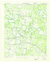
 1936 Greenfield Bend1936 Print · USGSThe Duck River valley comes to life in the mid-1930s, showing a network of rural schoolhouses and family cemeteries along the Hickman and Maury county lines. Researchers can trace the local landscape through landmarks like Kettle Mills, the Gordon Ferry Bridge, and Sheboss Cem.
 - 1936 Map of Carters Creek
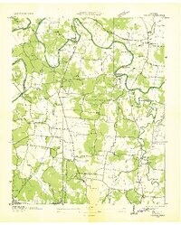
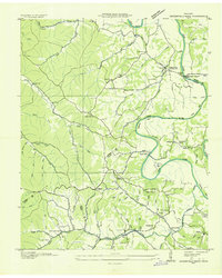
 1936 Carters Creek1936 Print · USGSThe northern reaches of Maury County are captured in the mid-1930s as the rural economy centered around the Rutherford Creek basin. Genealogists can locate family landmarks like Buford Cem, Smith Chapel, and the historic Greens Mill.
 - 1936 Map of Mount Pleasant
 1936 Mount Pleasant1936 Print · USGSMaury County's phosphate industry and rural settlements are caught in transition during the mid-1930s. Genealogists and historians can trace the industrial rail lines serving Phosphate Mines or locate family sites like Arlington Cem and Westbrook Ch.
 - 1936 Map of Glendale
 1936 Glendale1936 Print · USGSMaury County during the mid-1930s reveals a landscape defined by the winding loops of the Duck River and a dense network of family-named landmarks. Genealogists and local historians can trace legacy sites like Hardison Cem, Union Grove Sch, and the old Scribners Mill Bridge.
 - 1936 Map of Columbia
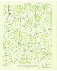
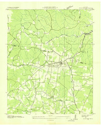
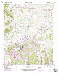
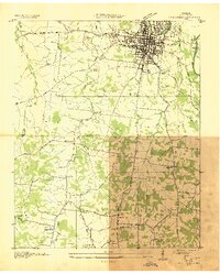 1936 Columbia1936 Print · USGSMaury County's seat and the surrounding Tennessee countryside are captured here in the mid-1930s during a period of significant infrastructural expansion. Researchers can trace historic family locations and civic sites like Bigbyville, Ephesus Ch, and the Columbia Mil Academy.2 unique versions available
 - 1936 Map of Lynnville
 1936 Lynnville1936 Print · USGSThe hills of Giles and Maury counties are captured here in the mid-1930s as the local phosphate industry was active. Genealogists can locate family-named landmarks and institutions like Chaffin Cem, Gipsonville Sch, and the Phosphate Mines.
 - 1940 Map of Godwin, 1954 Print
 1940 Godwin1954 Print · USGSMaury County's river-carved landscape is captured here in the mid-twentieth century, featuring the winding Duck River and its many valleys. Researchers can trace family history through sites like Old Knob Creek Cem, Darks Mill, and the Louisville and Nashville rail line.
 - 1941 Map of Godwin
 1941 Godwin1941 Print · USGSMaury County at the start of the 1940s is a landscape of winding river bends and tight-knit rural communities. Researchers can trace family history through numerous landmarks like Old Knob Creek Cem, Darks Mill, and the many country churches.
 - 1941 Map of Carters Creek
 1941 Carters Creek1941 Print · USGSCentral Tennessee at the start of the 1940s reveals a landscape of rural schoolhouses and family cemeteries along the Andrew Jackson Highway. Trace early mineral industry at the Phosphate Mine or locate ancestral sites like Old Brick Ch and Buford Cem.2 unique versions available
 - 1946 Map of Spring Hill, 1975 Print
 1946 Spring Hill1975 Print · USGSMid-century Middle Tennessee comes into focus as the Louisville and Nashville railroad tracks cut through the hills of Maury and Williamson Counties. Genealogists and historians can trace family plots like Harrison Cem and Patton Cem alongside landmarks such as Thompsons Station and the Mt Laverne School.3 unique versions available
 - 1946 Map of Mount Pleasant, 1987 Print
 1946 Mount Pleasant1987 Print · USGSMount Pleasant and its surrounding mining districts are captured here during a period of significant industrial expansion. Researchers can trace family-named cemeteries like Arlington Cem and Hunter Cem or explore early industrial sites like the MONSANTO CHEMICAL COMPANY works and local Strip Mines.
 - 1947 Map of Glendale, 1948 Print
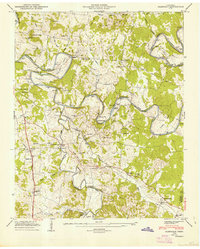 1947 Glendale1948 Print · USGSThe Duck River country of Maury County is captured here just after the war, showing a landscape defined by deep river bends and rural rail stops. Genealogists can locate dozens of family burial sites like Tankersley Cem and trace the Louisville & Nashville tracks through Park Station.6 unique versions available
Showing maps 1-25 of 48
Top cities of Maury County
Frequently asked questions
- What are the different types of historical maps available for Maury County?
- What is the oldest map of Maury County?
- Where can I purchase historical maps of Maury County for my home or office?
- Where can I download high-res historical maps of Maury County?
- Are there historical topographic maps available for Maury County?
- Is there historical aerial imagery available for Maury County?
- Where are historical maps of Maury County sourced from?