1930s Maps of Columbia, Tennessee
Explore 5 historic maps of Columbia from the 1930s. These maps offer a rare glimpse into what life looked like during the 1930s — showing old roads, neighborhoods, homes, and landmarks that have changed or disappeared over time.
Whether you're researching your family's past, planning a metal detecting trip, or studying how Columbia's landscape evolved across the 1930s, these high-resolution maps are a powerful tool for exploring the history of this region.
- Focus on a specific era: All maps on this page are from the 1930s, giving you a focused view of this time period.
- See what’s changed: Compare century-old streets, trails, and buildings to today's modern landscape using overlays and satellite layers.
- Research with precision: Use these maps for genealogy, historical research, land use analysis, or educational projects.
- View, download, or print: Maps are fully viewable online in high resolution, and can be downloaded or printed for your own records.
Start exploring Columbia's history through authentic maps from the 1930s. This is your window into the past.
Columbia, TN maps
(5)- 1936 Map of Godwin
 1936 Godwin1936 Print · USGSMaury County life in the mid-1930s is captured here, showing a landscape defined by the winding Duck River and local rail lines. Genealogists can locate family landmarks like Timmons Cem, the settlement at Darks Mill, and rural schools including Santa Fe Sch.
 - 1936 Map of Williamsport
 1936 Williamsport1936 Print · USGSMaury County's river valleys and phosphate industry are detailed in this mid-1930s survey of the region surrounding the Williamsport settlement. Genealogists can trace family landmarks and rural life through Zion Chapel, Jones Cem, and the Armour Phosphate Co works.
 - 1936 Map of Carters Creek
 1936 Carters Creek1936 Print · USGSThe northern reaches of Maury County are captured in the mid-1930s as the rural economy centered around the Rutherford Creek basin. Genealogists can locate family landmarks like Buford Cem, Smith Chapel, and the historic Greens Mill.
 - 1936 Map of Mount Pleasant
 1936 Mount Pleasant1936 Print · USGSMaury County's phosphate industry and rural settlements are caught in transition during the mid-1930s. Genealogists and historians can trace the industrial rail lines serving Phosphate Mines or locate family sites like Arlington Cem and Westbrook Ch.
 - 1936 Map of Columbia
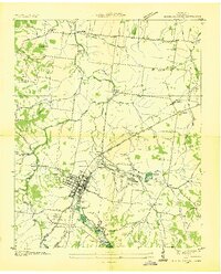
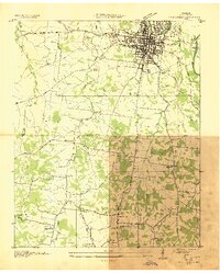 1936 Columbia1936 Print · USGSMaury County's seat and the surrounding Tennessee countryside are captured here in the mid-1930s during a period of significant infrastructural expansion. Researchers can trace historic family locations and civic sites like Bigbyville, Ephesus Ch, and the Columbia Mil Academy.2 unique versions available
End of results
Showing maps 1-5 of 5
Top cities near Columbia
- Franklin historical maps
- Spring Hill historical maps
- Lewisburg historical maps
- Mount Pleasant historical maps
- Thompson's Station historical maps
Top neighborhoods of Columbia
- Neapolis historical maps
- Fairview Heights historical maps
- Field Crest historical maps
- Forrest Hills historical maps
- Graymere Manor historical maps
- Highland Heights historical maps
See more
Frequently asked questions
- What are the different types of historical maps available for Columbia?
- What is the oldest map of Columbia?
- Where can I purchase historical maps of Columbia for my home or office?
- Where can I download high-res historical maps of Columbia?
- Are there historical topographic maps available for Columbia?
- Is there historical aerial imagery available for Columbia?
- Where are historical maps of Columbia sourced from?