1940s Maps of Columbia, Tennessee
Explore 5 historic maps of Columbia from the 1940s. These maps offer a rare glimpse into what life looked like during the 1940s — showing old roads, neighborhoods, homes, and landmarks that have changed or disappeared over time.
Whether you're researching your family's past, planning a metal detecting trip, or studying how Columbia's landscape evolved across the 1940s, these high-resolution maps are a powerful tool for exploring the history of this region.
- Focus on a specific era: All maps on this page are from the 1940s, giving you a focused view of this time period.
- See what’s changed: Compare century-old streets, trails, and buildings to today's modern landscape using overlays and satellite layers.
- Research with precision: Use these maps for genealogy, historical research, land use analysis, or educational projects.
- View, download, or print: Maps are fully viewable online in high resolution, and can be downloaded or printed for your own records.
Start exploring Columbia's history through authentic maps from the 1940s. This is your window into the past.
Columbia, TN maps
(5)- 1940 Map of Godwin, 1954 Print
 1940 Godwin1954 Print · USGSMaury County's river-carved landscape is captured here in the mid-twentieth century, featuring the winding Duck River and its many valleys. Researchers can trace family history through sites like Old Knob Creek Cem, Darks Mill, and the Louisville and Nashville rail line.
 - 1941 Map of Godwin
 1941 Godwin1941 Print · USGSMaury County at the start of the 1940s is a landscape of winding river bends and tight-knit rural communities. Researchers can trace family history through numerous landmarks like Old Knob Creek Cem, Darks Mill, and the many country churches.
 - 1941 Map of Carters Creek
 1941 Carters Creek1941 Print · USGSCentral Tennessee at the start of the 1940s reveals a landscape of rural schoolhouses and family cemeteries along the Andrew Jackson Highway. Trace early mineral industry at the Phosphate Mine or locate ancestral sites like Old Brick Ch and Buford Cem.2 unique versions available
 - 1946 Map of Mount Pleasant, 1987 Print
 1946 Mount Pleasant1987 Print · USGSMount Pleasant and its surrounding mining districts are captured here during a period of significant industrial expansion. Researchers can trace family-named cemeteries like Arlington Cem and Hunter Cem or explore early industrial sites like the MONSANTO CHEMICAL COMPANY works and local Strip Mines.
 - 1949 Map of Columbia
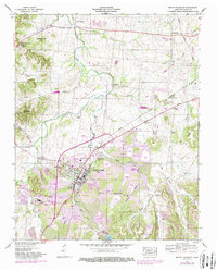
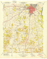 1949 Columbia1949 Print · USGSColumbia is captured here during a period of steady post-war growth along the Duck River and the Bee Line Highway. Researchers can locate vanished landmarks and family sites, from the Columbia Military Academy to rural gems like Rocky Glade Sch and the Ephesus Ch.2 unique versions available
End of results
Showing maps 1-5 of 5
Top cities near Columbia
- Franklin historical maps
- Spring Hill historical maps
- Lewisburg historical maps
- Mount Pleasant historical maps
- Thompson's Station historical maps
Top neighborhoods of Columbia
- Neapolis historical maps
- Fairview Heights historical maps
- Field Crest historical maps
- Forrest Hills historical maps
- Graymere Manor historical maps
- Highland Heights historical maps
See more
Frequently asked questions
- What are the different types of historical maps available for Columbia?
- What is the oldest map of Columbia?
- Where can I purchase historical maps of Columbia for my home or office?
- Where can I download high-res historical maps of Columbia?
- Are there historical topographic maps available for Columbia?
- Is there historical aerial imagery available for Columbia?
- Where are historical maps of Columbia sourced from?