1950s Maps of Columbia, Tennessee
Explore 3 historic maps of Columbia from the 1950s. These maps offer a rare glimpse into what life looked like during the 1950s — showing old roads, neighborhoods, homes, and landmarks that have changed or disappeared over time.
Whether you're researching your family's past, planning a metal detecting trip, or studying how Columbia's landscape evolved across the 1950s, these high-resolution maps are a powerful tool for exploring the history of this region.
- Focus on a specific era: All maps on this page are from the 1950s, giving you a focused view of this time period.
- See what’s changed: Compare century-old streets, trails, and buildings to today's modern landscape using overlays and satellite layers.
- Research with precision: Use these maps for genealogy, historical research, land use analysis, or educational projects.
- View, download, or print: Maps are fully viewable online in high resolution, and can be downloaded or printed for your own records.
Start exploring Columbia's history through authentic maps from the 1950s. This is your window into the past.
Columbia, TN maps
(3)- 1950 Map of Mount Pleasant
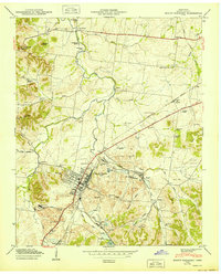 1950 Mount Pleasant1950 Print · USGSMaury County at the peak of its mid-century phosphate mining era reveals a landscape shaped by industry and community. Trace family roots at Arlington Cem or explore established neighborhoods like Red Row and Frierson Town near the LOUISVILLE & NASHVILLE rail line.2 unique versions available
 - 1951 Map of Williamsport, 1956 Print
 1951 Williamsport1956 Print · USGSMaury County at mid-century reveals a landscape shaped by the winding Duck River and burgeoning industrial mining. Researchers can trace family sites at Williamsport, find old rural landmarks like Woodrow Sch, or locate numerous cemeteries including McKennon Cem and Greenfield Cem.3 unique versions available
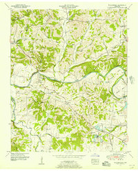
 - 1956 Map of Columbia, 1960 Print
 1956 Columbia1960 Print · USGSMiddle Tennessee in the mid-fifties presents a landscape of established river towns and critical rail hubs before the arrival of the modern interstate system. Researchers can trace the routes of the Louisville and Nashville railroad or locate historic landmarks like Stones River National Military Park and the Tennessee National Wildlife Refuge.6 unique versions available
End of results
Showing maps 1-3 of 3
Top cities near Columbia
- Franklin historical maps
- Spring Hill historical maps
- Lewisburg historical maps
- Mount Pleasant historical maps
- Thompson's Station historical maps
Top neighborhoods of Columbia
- Neapolis historical maps
- Fairview Heights historical maps
- Field Crest historical maps
- Forrest Hills historical maps
- Graymere Manor historical maps
- Highland Heights historical maps
See more
Frequently asked questions
- What are the different types of historical maps available for Columbia?
- What is the oldest map of Columbia?
- Where can I purchase historical maps of Columbia for my home or office?
- Where can I download high-res historical maps of Columbia?
- Are there historical topographic maps available for Columbia?
- Is there historical aerial imagery available for Columbia?
- Where are historical maps of Columbia sourced from?