1970s Maps of McMinn County, Tennessee
Explore 6 historic maps of McMinn County from the 1970s. These maps offer a rare glimpse into what life looked like during the 1970s — showing old roads, neighborhoods, homes, and landmarks that have changed or disappeared over time.
Whether you're researching your family's past, planning a metal detecting trip, or studying how McMinn County's landscape evolved across the 1970s, these high-resolution maps are a powerful tool for exploring the history of this region.
- Focus on a specific era: All maps on this page are from the 1970s, giving you a focused view of this time period.
- See what’s changed: Compare century-old streets, trails, and buildings to today's modern landscape using overlays and satellite layers.
- Research with precision: Use these maps for genealogy, historical research, land use analysis, or educational projects.
- View, download, or print: Maps are fully viewable online in high resolution, and can be downloaded or printed for your own records.
Start exploring McMinn County's history through authentic maps from the 1970s. This is your window into the past.
McMinn County, TN maps
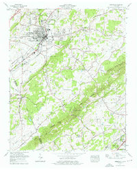
(6)- 1973 Map of Tranquillity, 1974 Print
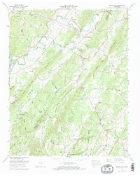 1973 Tranquillity1974 Print · USGSMcMinn County rural life and the ridges of East Tennessee are captured here in the early seventies. Genealogists can locate family landmarks like Hutsell Cem or Gibson Cem and historic community centers like Tranquillity and Collins Mill.2 unique versions available
 - 1973 Map of Pattie Gap, 1975 Print
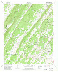 1973 Pattie Gap1975 Print · USGSThe intersection of Roane, Loudon, McMinn, and Meigs counties comes to life in the early 1970s. Researchers can locate family landmarks like Cook Mill, trace the numerous churches such as Johnson Chapel, or find ancestral burial sites at Blue Spring Cem.2 unique versions available
 - 1973 Map of Ten Mile, 1975 Print
 1973 Ten Mile1975 Print · USGSThe Tennessee River valley in the early 1970s reveals a landscape shaped by both the Watts Bar reservoir and long-standing rural settlements. Genealogists and historians can trace family locations at Hornsbys Chapel Cem, Ten Mile Sch, and the community at Culvahouse.2 unique versions available
 - 1973 Map of Decatur, 1975 Print
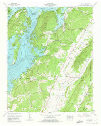
 1973 Decatur1975 Print · USGSMeigs County at the start of the 1970s shows a landscape transformed by the TVA's massive river projects and the rise of nuclear power. Researchers can trace family sites like Porter-Ward Cem or locate the Watts Bar Nuclear Plant while it was still under construction.2 unique versions available
 - 1974 Map of Niota, 1976 Print
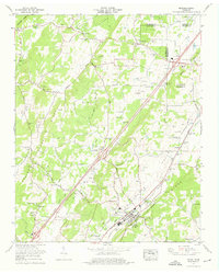 1974 Niota1976 Print · USGSNiota and the surrounding McMinn County valley are shown in the mid-seventies just as the rural landscape was balancing traditional agriculture with modern growth. Genealogists and local historians can trace family-named sites like Matlock Cem, Acme Mill, and the Pond Hill School.3 unique versions available
 - 1974 Map of Sweetwater, 1976 Print
 1974 Sweetwater1976 Print · USGSMonroe County and the Sweetwater Valley are captured here during a period of modern expansion in the mid-seventies. Local historians can trace family landmarks like Dickey Cem and Browder Memorial Ch or locate the unique Craighead Caverns (Lost Sea).2 unique versions available
End of results
Showing maps 1-6 of 6
Top cities of McMinn County
- Athens historical maps
- Etowah historical maps
- Englewood historical maps
- Niota historical maps
- Calhoun historical maps
Frequently asked questions
- What are the different types of historical maps available for McMinn County?
- What is the oldest map of McMinn County?
- Where can I purchase historical maps of McMinn County for my home or office?
- Where can I download high-res historical maps of McMinn County?
- Are there historical topographic maps available for McMinn County?
- Is there historical aerial imagery available for McMinn County?
- Where are historical maps of McMinn County sourced from?