2000-2009 Maps of McMinn County, Tennessee
Explore 3 historic maps of McMinn County from 2000-2009. These maps offer a rare glimpse into what life looked like during the 2000s — showing old roads, neighborhoods, homes, and landmarks that have changed or disappeared over time.
Whether you're researching your family's past, planning a metal detecting trip, or studying how McMinn County's landscape evolved across the 2000s, these high-resolution maps are a powerful tool for exploring the history of this region.
- Focus on a specific era: All maps on this page are from the 2000s, giving you a focused view of this time period.
- See what’s changed: Compare century-old streets, trails, and buildings to today's modern landscape using overlays and satellite layers.
- Research with precision: Use these maps for genealogy, historical research, land use analysis, or educational projects.
- View, download, or print: Maps are fully viewable online in high resolution, and can be downloaded or printed for your own records.
Start exploring McMinn County's history through authentic maps from the 2000s. This is your window into the past.
McMinn County, TN maps
(3)- 2003 Map of Etowah, 2004 Print
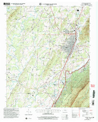 2003 Etowah2004 Print · USGSThe rail-driven hub of Etowah and the rugged slopes of the Cherokee National Forest meet in this detailed survey from the early 2000s. Researchers can trace family roots through sites like Jones Chapel Cem, Old Salem Ch, and the Delano Mill Pond.
 - 2003 Map of Benton, 2004 Print
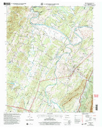 2003 Benton2004 Print · USGSBenton and the Hiwassee River valley are captured here at the turn of the millennium, showing a landscape shaped by river bends and pioneer roads. Genealogists can locate family landmarks like the Nancy Ward Cem, Benton Station, and the Old Federal Road.
 - 2003 Map of Mecca, 2004 Print
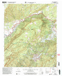 2003 Mecca2004 Print · USGSMonroe County and the Cherokee National Forest are captured here in the early twenty-first century as the high ridges of Starr Mountain meet the valley settlements. Trace local family history at Mecca Cem or find remote landmarks like White Cliff Springs and Rural Vale Ch.
End of results
Showing maps 1-3 of 3
Top cities of McMinn County
- Athens historical maps
- Etowah historical maps
- Englewood historical maps
- Niota historical maps
- Calhoun historical maps
Frequently asked questions
- What are the different types of historical maps available for McMinn County?
- What is the oldest map of McMinn County?
- Where can I purchase historical maps of McMinn County for my home or office?
- Where can I download high-res historical maps of McMinn County?
- Are there historical topographic maps available for McMinn County?
- Is there historical aerial imagery available for McMinn County?
- Where are historical maps of McMinn County sourced from?