1940s Maps of McNairy County, Tennessee
Explore 9 historic maps of McNairy County from the 1940s. These maps offer a rare glimpse into what life looked like during the 1940s — showing old roads, neighborhoods, homes, and landmarks that have changed or disappeared over time.
Whether you're researching your family's past, planning a metal detecting trip, or studying how McNairy County's landscape evolved across the 1940s, these high-resolution maps are a powerful tool for exploring the history of this region.
- Focus on a specific era: All maps on this page are from the 1940s, giving you a focused view of this time period.
- See what’s changed: Compare century-old streets, trails, and buildings to today's modern landscape using overlays and satellite layers.
- Research with precision: Use these maps for genealogy, historical research, land use analysis, or educational projects.
- View, download, or print: Maps are fully viewable online in high resolution, and can be downloaded or printed for your own records.
Start exploring McNairy County's history through authentic maps from the 1940s. This is your window into the past.
McNairy County, TN maps
(9)- 1949 Map of Pittsburg Landing, 1952 Print
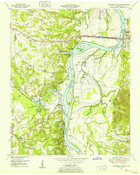 1949 Pittsburg Landing1952 Print · USGSHardin County history is centered on the hallowed grounds of Shiloh National Military Park and the vital banks of the Tennessee River in the late 1940s. Genealogists and historians can trace the riverside at Pittsburg Landing, locate the National Cem, or find rural family sites like Ledbetter Cem and Mt Zion Ch.
 - 1949 Map of Leapwood, 1952 Print
 1949 Leapwood1952 Print · USGSMcNairy County just before the mid-century mark shows a landscape of ridge-top farms and creek-bottom drainage projects. Genealogists can locate family landmarks like Baucum Cem, Hardin Beauty Church, and the Mud Creek Valley School.2 unique versions available
 - 1949 Map of Mt. Peter, 1952 Print
 1949 Mt. Peter1952 Print · USGSMcNairy and Chester Counties are captured here in the late 1940s, showing a rural landscape defined by the Tennessee Valley Divide. Researchers can trace old rail life in Finger or locate family sites like Mackey Sch and Mt Zion Ch.2 unique versions available
 - 1949 Map of Sardis, 1952 Print
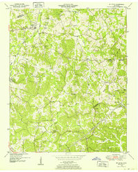
 1949 Sardis1952 Print · USGSSardis and the borderlands of Henderson, Chester, and Hardin Counties are captured here at the end of the 1940s. Genealogists and historians can locate family landmarks such as Brazelton Cem, Maria Bluff Ch, and the rural Tri-County School among the area's many drainage canals.2 unique versions available
 - 1949 Map of Purdy, 1952 Print
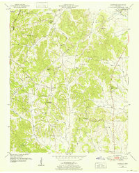
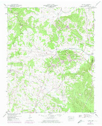
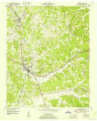 1949 Purdy1952 Print · USGSMcNairy County's rail and ridge landscapes come alive in this mid-century survey of the Tennessee Valley Divide. Genealogists and historians can trace the routes between Selmer and Bethel Springs, or locate rural landmarks like the County Farm and Bethesda Church.3 unique versions available
 - 1949 Map of Stantonville, 1952 Print
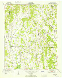
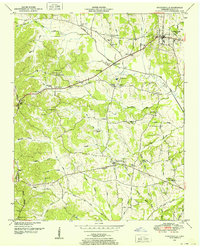 1949 Stantonville1952 Print · USGSMcNairy County in the late 1940s reveals a network of tight-knit rural communities and family landholdings. Genealogists and local historians can trace the foundations of Stantonville, Adamsville, and West Shiloh, alongside landmarks like Mt Zion Ch and New Delight Sch.3 unique versions available
 - 1949 Map of Milledgeville, 1952 Print
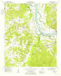
 1949 Milledgeville1952 Print · USGSWest Tennessee rural life and river geography are captured here in the late forties at the junction of Chester, McNairy, and Hardin counties. Researchers can trace family history at Sweeney Cem or locate the rural crossroads of Morris Chapel and Coffee Landing.2 unique versions available
 - 1949 Map of Counce, 1952 Print
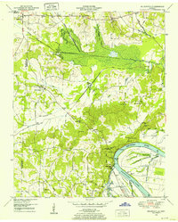
 1949 Counce1952 Print · USGSHardin County and the Tennessee River valley are captured here just after the war, showing the area's transition into the TVA era. Researchers can trace historic river access at Nash Landing, the grounds of Shiloh National Military Park, and local landmarks like Wayne Sch.
 - 1949 Map of Michie, 1974 Print
 1949 Michie1974 Print · USGSMcNairy County south of Stantonville is captured here mid-century, showing the crossroads communities and drainage canal projects of the era. Genealogists and local historians can trace the sites of Sand Hill Ch, the Chambers school, and burial grounds like Pleasant Site Cem.2 unique versions available
End of results
Showing maps 1-9 of 9
Top cities of McNairy County
- Selmer historical maps
- Adamsville historical maps
- Bethel Springs historical maps
- Michie historical maps
- Eastview historical maps
- Guys historical maps
See more
Frequently asked questions
- What are the different types of historical maps available for McNairy County?
- What is the oldest map of McNairy County?
- Where can I purchase historical maps of McNairy County for my home or office?
- Where can I download high-res historical maps of McNairy County?
- Are there historical topographic maps available for McNairy County?
- Is there historical aerial imagery available for McNairy County?
- Where are historical maps of McNairy County sourced from?