1940s Maps of Hiwassee Bruderhof, Tennessee
Explore 2 historic maps of Hiwassee Bruderhof from the 1940s. These maps offer a rare glimpse into what life looked like during the 1940s — showing old roads, neighborhoods, homes, and landmarks that have changed or disappeared over time.
Whether you're researching your family's past, planning a metal detecting trip, or studying how Hiwassee Bruderhof's landscape evolved across the 1940s, these high-resolution maps are a powerful tool for exploring the history of this region.
- Focus on a specific era: All maps on this page are from the 1940s, giving you a focused view of this time period.
- See what’s changed: Compare century-old streets, trails, and buildings to today's modern landscape using overlays and satellite layers.
- Research with precision: Use these maps for genealogy, historical research, land use analysis, or educational projects.
- View, download, or print: Maps are fully viewable online in high resolution, and can be downloaded or printed for your own records.
Start exploring Hiwassee Bruderhof's history through authentic maps from the 1940s. This is your window into the past.
Hiwassee Bruderhof, TN maps
(2)- 1940 Map of Madisonville
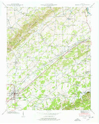 1940 Madisonville1940 Print · USGSMonroe County at the start of the 1940s reveals a landscape of ridges and creek-fed valleys centered on the rail hub of Madisonville. Researchers can trace old family sites and rural institutions like Hiwassee College, White Cem, and the Sequoyah Sch.4 unique versions available
 - 1941 Map of Madisonville
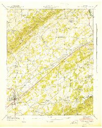 1941 Madisonville1941 Print · USGSMadisonville and the Tennessee hill country are captured here in the early 1940s as a landscape of small schools, country churches, and railroad commerce. Researchers can trace family roots at Hiwassee College, Hopewell Mill, or the Old Lutheran Cem.
End of results
Showing maps 1-2 of 2
Top cities near Hiwassee Bruderhof
- Athens historical maps
- Lenoir City historical maps
- Tellico Village historical maps
- Loudon historical maps
- Sweetwater historical maps
- Madisonville historical maps
See more
Frequently asked questions
- What are the different types of historical maps available for Hiwassee Bruderhof?
- What is the oldest map of Hiwassee Bruderhof?
- Where can I purchase historical maps of Hiwassee Bruderhof for my home or office?
- Where can I download high-res historical maps of Hiwassee Bruderhof?
- Are there historical topographic maps available for Hiwassee Bruderhof?
- Is there historical aerial imagery available for Hiwassee Bruderhof?
- Where are historical maps of Hiwassee Bruderhof sourced from?