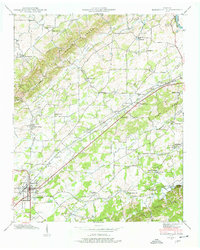
1940 Map of Madisonville
USGS Topo · Published 1940About this map
Madisonville serves as the focal point of this 1940 Tennessee Valley Authority survey, situated at the junction of several key regional routes and the Louisville and Nashville railroad. The landscape is defined by the Bat Creek Knobs and numerous winding waterways, including Bat Creek and Notchy Creek. The presence of Hiwassee College to the west and the Fair Grounds within the town limits highlights the area's role as an educational and social hub for Monroe County.
Find a feature on this map
53 named features on this map. Tap any name to fly to it.
Don’t see what you’re looking for? This feature index may not catch every label — zoom into the map to look around manually.
Map Details
Editions of this 1940 Madisonville Map
4 editions found
Other maps of this area

1893 · Murphy
USGS Topo · 1:125,000

1895 · Loudon
USGS Topo · 1:125,000

1914 · Murphy
USGS Topo · 1:125,000

1933 · Haw Knob
USGS Topo · 1:48,000

1933 · Rafter
USGS Topo · 1:24,000

1934 · Mount Vernon
USGS Topo · 1:24,000

1934 · Englewood
USGS Topo · 1:24,000

1935 · Tellico
USGS Topo · 1:48,000

1935 · Meadow
USGS Topo · 1:24,000

1935 · Philadelphia
USGS Topo · 1:24,000