1900s (20th Century) Maps of Sweetwater, Tennessee
Explore 18 historic maps of Sweetwater from the 1900s (20th Century). These maps offer a rare glimpse into what life looked like during the 1900s — showing old roads, neighborhoods, homes, and landmarks that have changed or disappeared over time.
Whether you're researching your family's past, planning a metal detecting trip, or studying how Sweetwater's landscape evolved across the 1900s, these high-resolution maps are a powerful tool for exploring the history of this region.
- Focus on a specific era: All maps on this page are from the 1900s, giving you a focused view of this time period.
- See what’s changed: Compare century-old streets, trails, and buildings to today's modern landscape using overlays and satellite layers.
- Research with precision: Use these maps for genealogy, historical research, land use analysis, or educational projects.
- View, download, or print: Maps are fully viewable online in high resolution, and can be downloaded or printed for your own records.
Start exploring Sweetwater's history through authentic maps from the 1900s. This is your window into the past.
Sweetwater, TN maps
(18)- 1935 Map of Niota
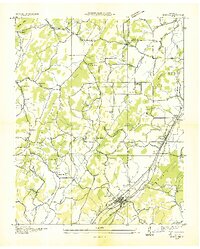 1935 Niota1935 Print · USGSNiota and the surrounding McMinn County countryside are shown here in the mid-1930s as the rail and highway network began to modernize the region. Researchers can locate early rural landmarks like Murphys Store, the Flume Mill, and several country schools including Pine Grove Sch.
 - 1935 Map of Philadelphia
 1935 Philadelphia1935 Print · USGSEastern Tennessee valley life comes into focus as the Tennessee Valley Authority begins its work. Genealogists can trace family roots through landmarks like Snows School, Reed Spring Church, and the settlement of Adolphus.
 - 1936 Map of Sweetwater
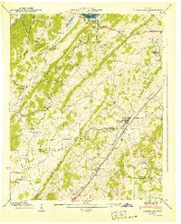
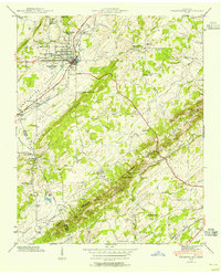
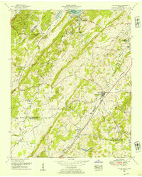
 1936 Sweetwater1936 Print · USGSSweetwater and the surrounding valley are shown here in the mid-1930s as the Tennessee Valley Authority began its regional work. Researchers can locate numerous vanished rural landmarks, including Tennessee Military Institute, Christianburg, and schools like High Point Sch and Liberality Sch.
 - 1940 Map of Philadelphia
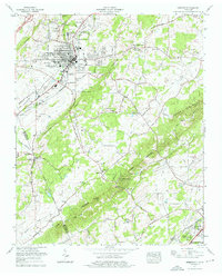
 1940 Philadelphia1940 Print · USGSThe Tennessee Valley just before the height of the war era shows a landscape of ridge-top schools and creek-side settlements. Researchers can trace ancestral locations at Philadelphia, the Roberson Cem, and rural centers like New Hope Ch.
 - 1941 Map of Sweetwater, 1954 Print
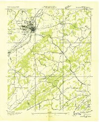
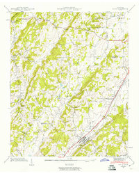
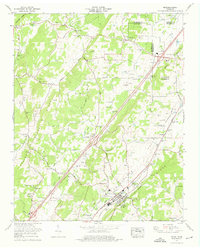
 1941 Sweetwater1954 Print · USGSIn the early 1940s, this Monroe County corridor was a bustling intersection of rail and road transport centered on Sweetwater. Genealogists can trace family roots through numerous country churches and schools like Watson Chapel, Liberality Sch, and Sharps Chapel Sch.
 - 1941 Map of Niota, 1960 Print
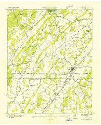
 1941 Niota1960 Print · USGSNiota and the surrounding McMinn County countryside are captured here in the early 1940s, following the path of the Southern Railway. Researchers can trace old agrarian roots at Barton Mill, local landmarks like Beulah Chapel, and small settlements including Prigmore.2 unique versions available
 - 1942 Map of Sweetwater
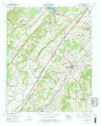
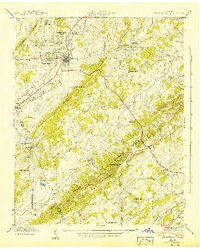 1942 Sweetwater1942 Print · USGSMonroe and McMinn counties in the early 1940s reveal a landscape of ridge-and-valley farming and early transit corridors. Genealogists can locate family landmarks like West View Cem, Tennessee Military Institute, and rural schools such as Sharps Chapel Sch.2 unique versions available
 - 1942 Map of Niota
 1942 Niota1942 Print · USGSNiota and the surrounding McMinn County valleys are captured here in the early 1940s as a landscape of small farms, railroad stops, and rural industry. Genealogists can locate family landmarks like Shearman Cem, Barton Mill, and the Murray Store.
 - 1952 Map of Philadelphia, 1954 Print
 1952 Philadelphia1954 Print · USGSPhiladelphia and the surrounding Tennessee valleys are captured here in the early fifties, showing a landscape defined by the Southern rail line and the Lee Highway. Trace the locations of family landmarks like the Wilson Cemetery, Snow School, and the settlement of Adolphus.
 - 1953 Map of Chattanooga
 1953 Chattanooga1953 Print · USGSSoutheast Tennessee in the early fifties shows a landscape reshaped by river management and rail power. Trace the rail lines of the Southern Ry through riverside towns or locate the preserved grounds of the Chickamauga and Chattanooga National Military Park.
 - 1957 Map of Chattanooga, 1966 Print
 1957 Chattanooga1966 Print · USGSEast Tennessee in the mid-1960s shows a landscape of massive hydroelectric reservoirs and emerging industrial sites like the Atomic Energy Commission (Oak Ridge Area). Trace the rail networks of the Southern Ry through Chattanooga or locate family-named ridges across the Cumberland Plateau.3 unique versions available
 - 1959 Map of Chattanooga
 1959 Chattanooga1959 Print · USGSSoutheast Tennessee is shown here during a decade of industrial growth and hydroelectric development. Trace the regional rail networks of the Southern Ry and find landmark sites like Lookout Mountain, Fall Creek Falls State Park, and Chattanooga.
 - 1960 Map of Chattanooga
 1960 Chattanooga1960 Print · USGSSoutheast Tennessee and the southern Appalachians are shown here at the height of the river-management era. You can trace the valley rail lines and locate Lookout Mountain and the expansive waters of Chickamauga Reservoir.
 - 1964 Map of Chattanooga
 1964 Chattanooga1964 Print · USGSSoutheast Tennessee and the western Carolinas appear in the mid-sixties as a powerhouse of river-driven industry and mountain wilderness. Genealogists and historians can trace rail-town lineages along the Southern Ry or locate family landmarks near Watts Bar Lake and Tellico Plains.
 - 1974 Map of Niota, 1976 Print
 1974 Niota1976 Print · USGSNiota and the surrounding McMinn County valley are shown in the mid-seventies just as the rural landscape was balancing traditional agriculture with modern growth. Genealogists and local historians can trace family-named sites like Matlock Cem, Acme Mill, and the Pond Hill School.3 unique versions available
 - 1974 Map of Sweetwater, 1976 Print
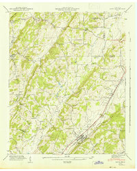
 1974 Sweetwater1976 Print · USGSMonroe County and the Sweetwater Valley are captured here during a period of modern expansion in the mid-seventies. Local historians can trace family landmarks like Dickey Cem and Browder Memorial Ch or locate the unique Craighead Caverns (Lost Sea).2 unique versions available
 - 1974 Map of Philadelphia, 1977 Print
 1974 Philadelphia1977 Print · USGSPhiladelphia and the surrounding valley ridges are shown here in the mid-seventies, tracing the corridor of the Southern Railway. Genealogists and historians can locate numerous family burial grounds and country chapels including Old Sweetwater Cem, Harris Cem, and Reed Spring Church.
 - 1981 Map of Watts Bar Lake, 1984 Print
 1981 Watts Bar Lake1984 Print · USGSEast Tennessee's river valleys and industrial corridors are captured here during the expansion of the TVA power system in the early eighties. Researchers can trace the legacy of the Southern Railway and the development of Watts Bar Lake and Tellico Lake.2 unique versions available
End of results
Showing maps 1-18 of 18
Top cities near Sweetwater
- Athens historical maps
- Lenoir City historical maps
- Tellico Village historical maps
- Loudon historical maps
- Madisonville historical maps
- Etowah historical maps
See more
Top neighborhoods of Sweetwater
Frequently asked questions
- What are the different types of historical maps available for Sweetwater?
- What is the oldest map of Sweetwater?
- Where can I purchase historical maps of Sweetwater for my home or office?
- Where can I download high-res historical maps of Sweetwater?
- Are there historical topographic maps available for Sweetwater?
- Is there historical aerial imagery available for Sweetwater?
- Where are historical maps of Sweetwater sourced from?