1930s Maps of Tariffville, Tennessee
Explore 3 historic maps of Tariffville from the 1930s. These maps offer a rare glimpse into what life looked like during the 1930s — showing old roads, neighborhoods, homes, and landmarks that have changed or disappeared over time.
Whether you're researching your family's past, planning a metal detecting trip, or studying how Tariffville's landscape evolved across the 1930s, these high-resolution maps are a powerful tool for exploring the history of this region.
- Focus on a specific era: All maps on this page are from the 1930s, giving you a focused view of this time period.
- See what’s changed: Compare century-old streets, trails, and buildings to today's modern landscape using overlays and satellite layers.
- Research with precision: Use these maps for genealogy, historical research, land use analysis, or educational projects.
- View, download, or print: Maps are fully viewable online in high resolution, and can be downloaded or printed for your own records.
Start exploring Tariffville's history through authentic maps from the 1930s. This is your window into the past.
Tariffville, TN maps
(3)- 1933 Map of Haw Knob
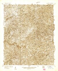 1933 Haw Knob1933 Print · USGSThe Tennessee-North Carolina borderlands come alive in this early 1930s survey, showing the deep creek valleys and high peaks of the southern mountains. Researchers can find old community hubs like Tallassee Sch, Ballplay Ch, and the remote Hemlock Lookout.2 unique versions available
 - 1933 Map of Rafter
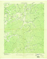 1933 Rafter1933 Print · USGSMonroe County was a landscape of remote mountain schools and country churches in the early 1930s. Genealogists can trace family footprints near Glenndale Sch, Quaker Ch, and small crossroads like Acorn and Tariffville.
 - 1937 Map of Haw Knob
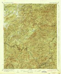 1937 Haw Knob1937 Print · USGSMonroe County and the borderlands of the Smokies are captured in the mid-1930s as the national forest system expanded across these high ridges. Genealogists and local historians can locate early landmarks like Whigg Cabin, Ballplay Church, and the isolated Waucheesi School.
End of results
Showing maps 1-3 of 3
Top cities near Tariffville
- Maryville historical maps
- Tellico Village historical maps
- Loudon historical maps
- Madisonville historical maps
- Greenback historical maps
- Tellico Plains historical maps
See more
Frequently asked questions
- What are the different types of historical maps available for Tariffville?
- What is the oldest map of Tariffville?
- Where can I purchase historical maps of Tariffville for my home or office?
- Where can I download high-res historical maps of Tariffville?
- Are there historical topographic maps available for Tariffville?
- Is there historical aerial imagery available for Tariffville?
- Where are historical maps of Tariffville sourced from?