2000-2009 Maps of Tellico West Industrial Complex, Vonore
Explore 2 historic maps of Tellico West Industrial Complex from 2000-2009. These maps offer a rare glimpse into what life looked like during the 2000s — showing old roads, neighborhoods, homes, and landmarks that have changed or disappeared over time.
Whether you're researching your family's past, planning a metal detecting trip, or studying how Tellico West Industrial Complex's landscape evolved across the 2000s, these high-resolution maps are a powerful tool for exploring the history of this region.
- Focus on a specific era: All maps on this page are from the 2000s, giving you a focused view of this time period.
- See what’s changed: Compare century-old streets, trails, and buildings to today's modern landscape using overlays and satellite layers.
- Research with precision: Use these maps for genealogy, historical research, land use analysis, or educational projects.
- View, download, or print: Maps are fully viewable online in high resolution, and can be downloaded or printed for your own records.
Start exploring Tellico West Industrial Complex's history through authentic maps from the 2000s. This is your window into the past.
Tellico West Industrial Complex, Vonore maps
(2)- 2003 Map of Madisonville, 2004 Print
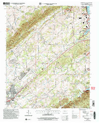 2003 Madisonville2004 Print · USGSMadisonville and the Monroe County foothills are captured in the early 2000s, reflecting a rural landscape defined by historic schools and family homesteads. Researchers can trace the grounds of Hiwassee College, locate the Old Lutheran Cem, and follow the banks of Bat Creek.
 - 2003 Map of Vonore, 2004 Print
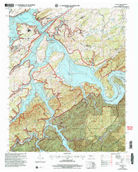 2003 Vonore2004 Print · USGSEastern Tennessee at the start of the millennium centers on the vast waters of Tellico Lake and the confluence of major rivers. Researchers can trace historical sites like Fort Loudoun State Historic Area alongside local landmarks like Toqua Cem and Vonore.
End of results
Showing maps 1-2 of 2
Frequently asked questions
- What are the different types of historical maps available for Tellico West Industrial Complex?
- What is the oldest map of Tellico West Industrial Complex?
- Where can I purchase historical maps of Tellico West Industrial Complex for my home or office?
- Where can I download high-res historical maps of Tellico West Industrial Complex?
- Are there historical topographic maps available for Tellico West Industrial Complex?
- Is there historical aerial imagery available for Tellico West Industrial Complex?
- Where are historical maps of Tellico West Industrial Complex sourced from?