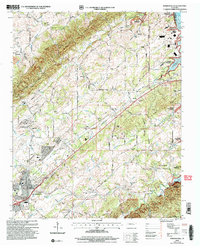
2003 Map of Madisonville
USGS Topo · Published 2004About this map
The rolling landscape of Madisonville and its surrounding Monroe County uplands are documented here, showing a community structured by long-standing institutional foundations. Education and faith are central to the landscape, anchored by the campus of Hiwassee College and a network of rural schoolhouses like Brakebill Sch and Phillips Sch. The terrain is characterized by prominent ridges such as Negro Ridge and Acorn Gap, with the northeast corner featuring the waters of Tellico Lake. Local history is preserved in numerous family and community burial grounds, including the Old Lutheran Cem and Kimbrough Cem. The map illustrates the era's infrastructure, from the Pipeline cutting through the western fields to the designated Tellico Reservation Boundary that borders the northern reaches of Bat Creek.
Find a feature on this map
76 named features on this map. Tap any name to fly to it.
Don’t see what you’re looking for? This feature index may not catch every label — zoom into the map to look around manually.
Map Details
Editions of this 2003 Madisonville Map
This is the sole edition of this map. No revisions or reprints were ever made.
Other maps of this area

1893 · Murphy
USGS Topo · 1:125,000

1895 · Loudon
USGS Topo · 1:125,000

1914 · Murphy
USGS Topo · 1:125,000

1933 · Haw Knob
USGS Topo · 1:48,000

1933 · Rafter
USGS Topo · 1:24,000

1934 · Mount Vernon
USGS Topo · 1:24,000

1934 · Englewood
USGS Topo · 1:24,000

1935 · Tellico
USGS Topo · 1:48,000

1935 · Meadow
USGS Topo · 1:24,000

1935 · Philadelphia
USGS Topo · 1:24,000