1950s Maps of Morgan County, Tennessee
Explore 21 historic maps of Morgan County from the 1950s. These maps offer a rare glimpse into what life looked like during the 1950s — showing old roads, neighborhoods, homes, and landmarks that have changed or disappeared over time.
Whether you're researching your family's past, planning a metal detecting trip, or studying how Morgan County's landscape evolved across the 1950s, these high-resolution maps are a powerful tool for exploring the history of this region.
- Focus on a specific era: All maps on this page are from the 1950s, giving you a focused view of this time period.
- See what’s changed: Compare century-old streets, trails, and buildings to today's modern landscape using overlays and satellite layers.
- Research with precision: Use these maps for genealogy, historical research, land use analysis, or educational projects.
- View, download, or print: Maps are fully viewable online in high resolution, and can be downloaded or printed for your own records.
Start exploring Morgan County's history through authentic maps from the 1950s. This is your window into the past.
Morgan County, TN maps
(21)- 1952 Map of Honey Creek, 1953 Print
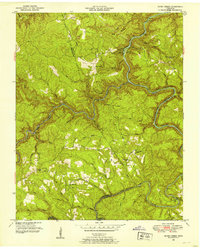 1952 Honey Creek1953 Print · USGSScott and Fentress counties are documented in the early 1950s, showing a landscape of river-carved ridges and remote homesteads. Genealogists can trace family connections at Blevins Cem or locate the sites of Honey Creek School and Zenith.6 unique versions available
 - 1952 Map of Rugby, 1953 Print
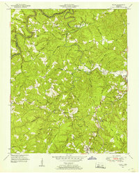 1952 Rugby1953 Print · USGSThe Morgan and Scott County borderlands appear here in the early fifties as a landscape of timbered hills and railway towns. Researchers can trace family history through numerous burial sites like Rugby Cem and Webb Cem or follow the Southern Railway through Sixteen Tunnel.4 unique versions available
 - 1952 Map of Robbins, 1953 Print
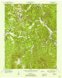 1952 Robbins1953 Print · USGSCoal and rail dominate this Scott County landscape in the early fifties, where mountain ridges are etched with Strip Mines. Researchers can trace rural life at Campground Sch and family roots at Shipard Cem or Black Creek Cem.3 unique versions available
 - 1952 Map of Fork Mountain, 1954 Print
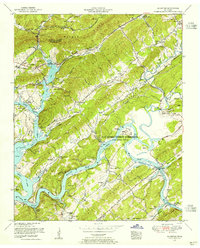
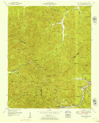 1952 Fork Mountain1954 Print · USGSThe Cumberland Plateau landscape at the start of the fifties reveals a coal-driven economy where mountain hamlets like Mahan Village and Moores Camp line the river valleys. Genealogists can trace family heritage through sites like Beech Grove Church and the Reeves-Daugherty Cemetery.5 unique versions available
 - 1952 Map of Pilot Mountain, 1954 Print
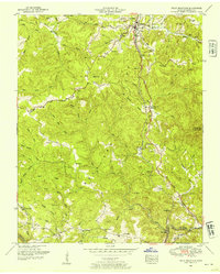 1952 Pilot Mountain1954 Print · USGSMorgan County is shown in the early fifties as the railroad and small farming communities defined life on the Cumberland Plateau. Genealogists can trace family names at Hendren Cemetery, locate the old Abandoned tunnel, and explore rural centers like Sunbright and Annadel.3 unique versions available
 - 1952 Map of Windrock, 1954 Print
 1952 Windrock1954 Print · USGSIn the early fifties, the Anderson County landscape was transforming from a coal-mining region into a center of the atomic age. Genealogists and historians can trace family cemeteries like Grave Hill Cemetery alongside the growth of Oak Ridge and Oliver Springs.2 unique versions available
 - 1952 Map of Cardiff, 1954 Print
 1952 Cardiff1954 Print · USGSThe ridges of Roane and Morgan counties meet in the early fifties, showing the industrial rail corridor alongside traditional mountain life. Genealogists can trace family names at Skidmore Cemetery or Snow Cemetery and locate rural landmarks like Dry Hill School.2 unique versions available
 - 1952 Map of Gobey, 1954 Print
 1952 Gobey1954 Print · USGSThe Cumberland Plateau landscape comes to life in the early fifties as the Emory River winds past small mountain communities. Genealogists can trace family footprints through the McCartt Cemetery, Elizabeth School, and the settlement of Gobey.3 unique versions available
 - 1952 Map of Harriman, 1954 Print
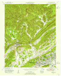
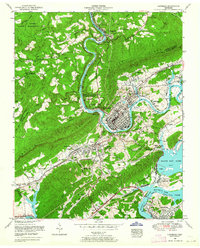
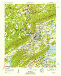 1952 Harriman1954 Print · USGSThe river towns of Harriman and Kingston are captured in the early 1950s as the Tennessee Valley Authority shaped the local landscape. Genealogists can locate family landmarks such as Harriman Cemetery, Rankin School, and Williams Chapel.
 - 1952 Map of Lancing, 1955 Print
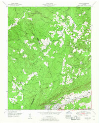
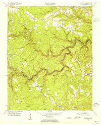
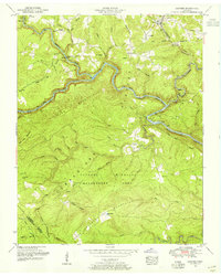 1952 Lancing1955 Print · USGSMorgan County is surveyed here in the early fifties, showing the high plateaus and river gorges before modern development. Researchers can trace family history through sites like Howard Mill, Clear Creek Church, and several remote family cemeteries.6 unique versions available
 - 1952 Map of Petros, 1955 Print
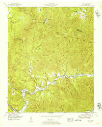
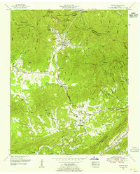 1952 Petros1955 Print · USGSMorgan County is shown in the early fifties as coal mining and state forestry operations shaped life along the Southern Railway. Genealogists can trace family names through the Brasel Cemetery, Joyner School, and the community surrounding Brushy Mountain State Prison.4 unique versions available
 - 1952 Map of Camp Austin, 1956 Print
 1952 Camp Austin1956 Print · USGSThe area surrounding Wartburg in the early fifties is captured here as a landscape of river-cut valleys and upland plateaus. Genealogists and historians can trace family-named sites like Summers Cemetery and the Brushy Mountain State Penal Farm.5 unique versions available
 - 1953 Map of Chattanooga
 1953 Chattanooga1953 Print · USGSSoutheast Tennessee in the early fifties shows a landscape reshaped by river management and rail power. Trace the rail lines of the Southern Ry through riverside towns or locate the preserved grounds of the Chickamauga and Chattanooga National Military Park.
 - 1953 Map of Elverton, 1955 Print
 1953 Elverton1955 Print · USGSThe Roane County hills and the newly formed Watts Bar Lake meet the Oak Ridge Area in the early 1950s. Trace local history through the Slave Cemetery, Coal Hill Church, and family settlements like Elverton.2 unique versions available
 - 1953 Map of Harriman, 1964 Print
 1953 Harriman1964 Print · USGSIn the early fifties, the confluence of the Emory and Clinch Rivers anchored a landscape of burgeoning energy and deep-rooted rail history. Genealogists and historians can trace the foundations of Harriman alongside local landmarks like Rankin School and the Kingston Steam Plant.
 - 1954 Map of Burrville, 1955 Print
 1954 Burrville1955 Print · USGSMid-century Fentress County is defined here by the deep gorge of the Clear Fork and the remote settlements of the plateau. Local historians can locate vanished landmarks like Silver Pine Sch and Gatewood Bridge or trace family roots near Armathwaite.4 unique versions available
 - 1954 Map of Grimsley, 1955 Print
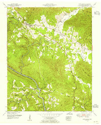
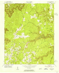 1954 Grimsley1955 Print · USGSMid-century Fentress County is captured here as the Cumberland Plateau plateau communities of Grimsley and Banner Springs centered along the Alvin C York Highway. Researchers can locate numerous family burial grounds and country schools like the Tench Sch and Ward Cem.4 unique versions available
 - 1956 Map of Corbin, 1966 Print
 1956 Corbin1966 Print · USGSThe Kentucky and Tennessee borderlands are captured here in the mid-fifties, showing the region's shift toward modern interstate travel and reservoir development. Genealogists and historians can trace old community lines near Albany and Monticello or locate early rail junctions along the Southern and Tennessee Central lines.3 unique versions available
 - 1957 Map of Chattanooga, 1966 Print
 1957 Chattanooga1966 Print · USGSEast Tennessee in the mid-1960s shows a landscape of massive hydroelectric reservoirs and emerging industrial sites like the Atomic Energy Commission (Oak Ridge Area). Trace the rail networks of the Southern Ry through Chattanooga or locate family-named ridges across the Cumberland Plateau.3 unique versions available
 - 1958 Map of Corbin
 1958 Corbin1958 Print · USGSThe Upper Cumberland borderlands appear in the late 1950s as massive reservoirs and early atomic-era growth reshape the region. Trace family roots and vanished landmarks near Lake Cumberland, Oak Ridge, and the Cumberland National Forest.
 - 1959 Map of Chattanooga
 1959 Chattanooga1959 Print · USGSSoutheast Tennessee is shown here during a decade of industrial growth and hydroelectric development. Trace the regional rail networks of the Southern Ry and find landmark sites like Lookout Mountain, Fall Creek Falls State Park, and Chattanooga.
End of results
Showing maps 1-21 of 21
Top cities of Morgan County
Frequently asked questions
- What are the different types of historical maps available for Morgan County?
- What is the oldest map of Morgan County?
- Where can I purchase historical maps of Morgan County for my home or office?
- Where can I download high-res historical maps of Morgan County?
- Are there historical topographic maps available for Morgan County?
- Is there historical aerial imagery available for Morgan County?
- Where are historical maps of Morgan County sourced from?