1900s (20th Century) Maps of Union City, Tennessee
Explore 6 historic maps of Union City from the 1900s (20th Century). These maps offer a rare glimpse into what life looked like during the 1900s — showing old roads, neighborhoods, homes, and landmarks that have changed or disappeared over time.
Whether you're researching your family's past, planning a metal detecting trip, or studying how Union City's landscape evolved across the 1900s, these high-resolution maps are a powerful tool for exploring the history of this region.
- Focus on a specific era: All maps on this page are from the 1900s, giving you a focused view of this time period.
- See what’s changed: Compare century-old streets, trails, and buildings to today's modern landscape using overlays and satellite layers.
- Research with precision: Use these maps for genealogy, historical research, land use analysis, or educational projects.
- View, download, or print: Maps are fully viewable online in high resolution, and can be downloaded or printed for your own records.
Start exploring Union City's history through authentic maps from the 1900s. This is your window into the past.
Union City, TN maps
(6)- 1954 Map of Union City, 1955 Print
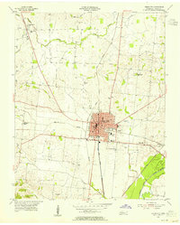 1954 Union City1955 Print · USGSMid-century Obion County comes alive in this survey of Union City and its surrounding rail corridors. Researchers can trace the heritage of local families through landmarks like East View Cemetery, McDowell Chapel, and Woodland Mills.2 unique versions available
 - 1956 Map of Harris, 1958 Print
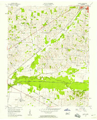 1956 Harris1958 Print · USGSThe borderlands of Obion and Weakley Counties are shown in the mid-fifties, centered on the North Fork Obion River. Researchers can trace old rail lines like the Illinois Central and find family landmarks like Morris Slave Cem and Pierce Station.3 unique versions available
 - 1956 Map of Dyersburg, 1960 Print
 1956 Dyersburg1960 Print · USGSThe Four Rivers region comes alive in the mid-fifties, capturing the intricate borderlands of Tennessee, Kentucky, and Missouri. Genealogists and historians can trace the rail-and-river networks connecting Dyersburg, Caruthersville, and the shoreline of Reelfoot Lake.4 unique versions available
 - 1972 Map of Martin
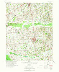 1972 Martin1972 Print · USGSWeakley and Obion Counties are captured here in the early 1970s as agricultural communities centered around the rail junction at Martin. Genealogists can trace family landmarks like Morris Slave Cem, Chestnut Glade Sch, and the Crockett Cem.
 - 1983 Map of Dyersburg
 1983 Dyersburg1983 Print · USGSSpanning the Mississippi River at the start of the 1980s, this area shows the vital river-and-rail connections between Tennessee and Missouri. Researchers can trace family sites at Mount Pisgah Cemetery or study the evolving shoreline near Caruthersville and Reelfoot Lake.
 - 1986 Map of McKenzie
 1986 McKenzie1986 Print · USGSWest Tennessee in the mid-eighties was a landscape defined by its deep river forks and the massive waters of Kentucky Lake. Researchers can trace the rail lines of the Louisville & Nashville RR and find local landmarks from Skullbone to the Paris Landing State Park.3 unique versions available
End of results
Showing maps 1-6 of 6
Top cities near Union City
- Martin historical maps
- Fulton historical maps
- South Fulton historical maps
- Hickman historical maps
- Troy historical maps
- Obion historical maps
See more
Top neighborhoods of Union City
Frequently asked questions
- What are the different types of historical maps available for Union City?
- What is the oldest map of Union City?
- Where can I purchase historical maps of Union City for my home or office?
- Where can I download high-res historical maps of Union City?
- Are there historical topographic maps available for Union City?
- Is there historical aerial imagery available for Union City?
- Where are historical maps of Union City sourced from?