1900s (20th Century) Maps of Blue Sky, Tennessee
Explore 4 historic maps of Blue Sky from the 1900s (20th Century). These maps offer a rare glimpse into what life looked like during the 1900s — showing old roads, neighborhoods, homes, and landmarks that have changed or disappeared over time.
Whether you're researching your family's past, planning a metal detecting trip, or studying how Blue Sky's landscape evolved across the 1900s, these high-resolution maps are a powerful tool for exploring the history of this region.
- Focus on a specific era: All maps on this page are from the 1900s, giving you a focused view of this time period.
- See what’s changed: Compare century-old streets, trails, and buildings to today's modern landscape using overlays and satellite layers.
- Research with precision: Use these maps for genealogy, historical research, land use analysis, or educational projects.
- View, download, or print: Maps are fully viewable online in high resolution, and can be downloaded or printed for your own records.
Start exploring Blue Sky's history through authentic maps from the 1900s. This is your window into the past.
Blue Sky, TN maps
(4)- 1936 Map of Daniels Landing
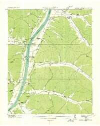 1936 Daniels Landing1936 Print · USGSLife along the Tennessee River in the mid-1930s was defined by its landings and creek-side communities before major dam projects altered the valley. Genealogists can trace family landmarks like Britt Chapel Cem, Daniels Landing, and the school at Oakview Sch.
 - 1949 Map of Daniels Landing, 1953 Print
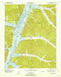 1949 Daniels Landing1953 Print · USGSWest Tennessee river life is captured here in the late 1940s as the valley adapted to the creation of Kentucky Lake. Researchers can trace old family sites and river landings such as Daniels Landing, Blue Creek School, and Britta Chapel.3 unique versions available
 - 1956 Map of Columbia, 1960 Print
 1956 Columbia1960 Print · USGSMiddle Tennessee in the mid-fifties presents a landscape of established river towns and critical rail hubs before the arrival of the modern interstate system. Researchers can trace the routes of the Louisville and Nashville railroad or locate historic landmarks like Stones River National Military Park and the Tennessee National Wildlife Refuge.6 unique versions available
 - 1986 Map of Hohenwald
 1986 Hohenwald1986 Print · USGSThe Western Highland Rim of Tennessee comes into focus during the mid-eighties, showing the deep river valleys and high ridges of Lewis and Perry counties. Researchers can trace the path of the Natchez Trace Parkway or locate interior settlements like Chestnut Grove, Farmers Exchange, and Hustburg.3 unique versions available
End of results
Showing maps 1-4 of 4
Top cities near Blue Sky
- Camden historical maps
- Parsons historical maps
- New Johnsonville historical maps
- Linden historical maps
- Lobelville historical maps
- Decaturville historical maps
Frequently asked questions
- What are the different types of historical maps available for Blue Sky?
- What is the oldest map of Blue Sky?
- Where can I purchase historical maps of Blue Sky for my home or office?
- Where can I download high-res historical maps of Blue Sky?
- Are there historical topographic maps available for Blue Sky?
- Is there historical aerial imagery available for Blue Sky?
- Where are historical maps of Blue Sky sourced from?