1900s (20th Century) Maps of Ducktown, Tennessee
Explore 14 historic maps of Ducktown from the 1900s (20th Century). These maps offer a rare glimpse into what life looked like during the 1900s — showing old roads, neighborhoods, homes, and landmarks that have changed or disappeared over time.
Whether you're researching your family's past, planning a metal detecting trip, or studying how Ducktown's landscape evolved across the 1900s, these high-resolution maps are a powerful tool for exploring the history of this region.
- Focus on a specific era: All maps on this page are from the 1900s, giving you a focused view of this time period.
- See what’s changed: Compare century-old streets, trails, and buildings to today's modern landscape using overlays and satellite layers.
- Research with precision: Use these maps for genealogy, historical research, land use analysis, or educational projects.
- View, download, or print: Maps are fully viewable online in high resolution, and can be downloaded or printed for your own records.
Start exploring Ducktown's history through authentic maps from the 1900s. This is your window into the past.
Ducktown, TN maps
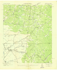
(14)- 1914 Map of Murphy
 1914 Murphy1914 Print · USGSThe Tennessee-North Carolina borderlands come to life in this early twentieth-century survey, showcasing a landscape of mountain ridges and river-driven commerce. Researchers can trace the Louisville and Nashville Railroad to old stops like Apalachia Sta or locate the historic Prince Ferry and White Cliff Springs.3 unique versions available
 - 1936 Map of Isabella
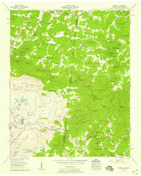
 1936 Isabella1936 Print · USGSThe copper-mining industrial landscape of the Tennessee and North Carolina border is caught here in the mid-1930s. Genealogists and historians can trace company towns and local landmarks like the Isabella Mine, Stewardtown, and the Kimsey Sch.
 - 1936 Map of Ducktown
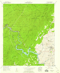
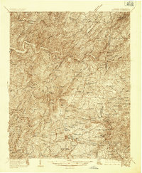 1936 Ducktown1936 Print · USGSThe Tennessee and North Carolina borderlands come to life in the mid-1930s as the Copper Basin mining boom reaches its peak. Researchers can locate vanished infrastructure like the Tennessee Copper Co RR and legendary sites including the Burra Burra Mine and Kimsey Junior College.
 - 1936 Map of Postelle
 1936 Postelle1936 Print · USGSPolk County was a hub of mining and hydroelectric power in the mid-1930s as the Tennessee Valley Authority reshaped the landscape. Researchers can trace ancestral roots at Kimsey Junior College or locate industrial sites like the Burra Burra Mine and Beckners Mill.
 - 1943 Map of Ducktown
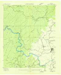
 1943 Ducktown1943 Print · USGSSoutheast Tennessee mining country is captured here during the 1940s as the regional copper industry reached its peak. Genealogists and historians can trace industrial footprints at the Burra Burra Mine or locate families near Freelingtown and the Ironsburg Sch.2 unique versions available
 - 1953 Map of Chattanooga
 1953 Chattanooga1953 Print · USGSSoutheast Tennessee in the early fifties shows a landscape reshaped by river management and rail power. Trace the rail lines of the Southern Ry through riverside towns or locate the preserved grounds of the Chickamauga and Chattanooga National Military Park.
 - 1957 Map of Ducktown, 1959 Print
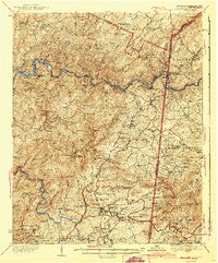
 1957 Ducktown1959 Print · USGSThe copper industry and mountain wilderness met in the late fifties near the Tennessee-Georgia border. Genealogists and industrial historians can trace the Burra Burra Mine, the Louisville and Nashville rail line, and the waters of Ocoee No 3 Lake.4 unique versions available
 - 1957 Map of Isabella, 1959 Print
 1957 Isabella1959 Print · USGSThe copper-rich Copper Basin of Tennessee and North Carolina is captured here in the late fifties, showing a landscape shaped by industrial extraction and rail. Genealogists and historians can locate the Isabella Mine, the London Flotation Plant, and family landmarks like Padgett Cem or Burger Town.4 unique versions available
 - 1957 Map of Chattanooga, 1966 Print
 1957 Chattanooga1966 Print · USGSEast Tennessee in the mid-1960s shows a landscape of massive hydroelectric reservoirs and emerging industrial sites like the Atomic Energy Commission (Oak Ridge Area). Trace the rail networks of the Southern Ry through Chattanooga or locate family-named ridges across the Cumberland Plateau.3 unique versions available
 - 1959 Map of Chattanooga
 1959 Chattanooga1959 Print · USGSSoutheast Tennessee is shown here during a decade of industrial growth and hydroelectric development. Trace the regional rail networks of the Southern Ry and find landmark sites like Lookout Mountain, Fall Creek Falls State Park, and Chattanooga.
 - 1960 Map of Chattanooga
 1960 Chattanooga1960 Print · USGSSoutheast Tennessee and the southern Appalachians are shown here at the height of the river-management era. You can trace the valley rail lines and locate Lookout Mountain and the expansive waters of Chickamauga Reservoir.
 - 1964 Map of Chattanooga
 1964 Chattanooga1964 Print · USGSSoutheast Tennessee and the western Carolinas appear in the mid-sixties as a powerhouse of river-driven industry and mountain wilderness. Genealogists and historians can trace rail-town lineages along the Southern Ry or locate family landmarks near Watts Bar Lake and Tellico Plains.
 - 1981 Map of Cleveland
 1981 Cleveland1981 Print · USGSSoutheast Tennessee and Western North Carolina are documented here in the early eighties, as the Tennessee Valley Authority managed the region's vast river and forest resources. Researchers can trace the rail lines of the Southern and Louisville and Nashville or locate industrial sites in the Copper Basin and settlements like Ducktown.2 unique versions available
 - 1999 Map of Ducktown, 2001 Print
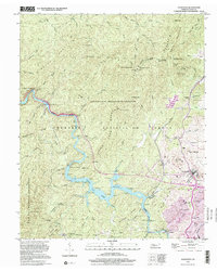 1999 Ducktown2001 Print · USGSThe Tennessee Copper Basin is revealed in the late twentieth century, showing a landscape shaped by mining and hydroelectric power. Researchers can trace the L & N RR through Ducktown or locate the historic Burra Burra Mine and Hiwassee Mine.
End of results
Showing maps 1-14 of 14
Top cities near Ducktown
- McCaysville historical maps
- Blue Ridge historical maps
- Copperhill historical maps
- Morganton historical maps
Frequently asked questions
- What are the different types of historical maps available for Ducktown?
- What is the oldest map of Ducktown?
- Where can I purchase historical maps of Ducktown for my home or office?
- Where can I download high-res historical maps of Ducktown?
- Are there historical topographic maps available for Ducktown?
- Is there historical aerial imagery available for Ducktown?
- Where are historical maps of Ducktown sourced from?