1930s Maps of Kingston, Tennessee
Explore 4 historic maps of Kingston from the 1930s. These maps offer a rare glimpse into what life looked like during the 1930s — showing old roads, neighborhoods, homes, and landmarks that have changed or disappeared over time.
Whether you're researching your family's past, planning a metal detecting trip, or studying how Kingston's landscape evolved across the 1930s, these high-resolution maps are a powerful tool for exploring the history of this region.
- Focus on a specific era: All maps on this page are from the 1930s, giving you a focused view of this time period.
- See what’s changed: Compare century-old streets, trails, and buildings to today's modern landscape using overlays and satellite layers.
- Research with precision: Use these maps for genealogy, historical research, land use analysis, or educational projects.
- View, download, or print: Maps are fully viewable online in high resolution, and can be downloaded or printed for your own records.
Start exploring Kingston's history through authentic maps from the 1930s. This is your window into the past.
Kingston, TN maps
(4)- 1935 Map of Elverton
 1935 Elverton1935 Print · USGSMid-1930s Roane County and Morgan County were characterized by river-bottom agriculture and ridgeline settlements before the arrival of the atomic age. Genealogists can trace family landmarks like Gallagher Ferry, Orchard View Sch, and the community of Wheat.
 - 1935 Map of Harriman
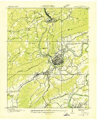 1935 Harriman1935 Print · USGSMid-1930s Roane County reveals a busy rail and river corridor where the Cumberland Escarpment meets the Tennessee Valley. Genealogists and historians can trace family landmarks like Suddaths Ferry, Bazzletown Sch, and the grounds of CCC Camp No 37.
 - 1936 Map of Cave Creek
 1936 Cave Creek1936 Print · USGSThe river valleys of Roane and Loudon Counties are captured here in the mid-1930s before decades of modernization. Genealogists can trace family landmarks like Ladd Cem, Norman Cem, and schools such as Matlock School and Beech Grove School.
 - 1936 Map of Bacon Gap
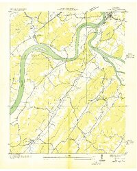 1936 Bacon Gap1936 Print · USGSRoane County in the mid-1930s shows a landscape shaped by its great river junction and rural ridge communities. Genealogists can locate family landmarks like Bethel Cem, Barnetts Narrows, and river crossings such as James Ferry and Hood Landing Ferry.2 unique versions available
End of results
Showing maps 1-4 of 4
Top cities near Kingston
- Oak Ridge historical maps
- Lenoir City historical maps
- Tellico Village historical maps
- Harriman historical maps
- Loudon historical maps
- Rockwood historical maps
See more
Top neighborhoods of Kingston
- Oak Hills historical maps
- Laddie Village historical maps
- Lawnville Meadows historical maps
- Cherokee Hills historical maps
Frequently asked questions
- What are the different types of historical maps available for Kingston?
- What is the oldest map of Kingston?
- Where can I purchase historical maps of Kingston for my home or office?
- Where can I download high-res historical maps of Kingston?
- Are there historical topographic maps available for Kingston?
- Is there historical aerial imagery available for Kingston?
- Where are historical maps of Kingston sourced from?