1960s Maps of Rockwood, Tennessee
Explore 6 historic maps of Rockwood from the 1960s. These maps offer a rare glimpse into what life looked like during the 1960s — showing old roads, neighborhoods, homes, and landmarks that have changed or disappeared over time.
Whether you're researching your family's past, planning a metal detecting trip, or studying how Rockwood's landscape evolved across the 1960s, these high-resolution maps are a powerful tool for exploring the history of this region.
- Focus on a specific era: All maps on this page are from the 1960s, giving you a focused view of this time period.
- See what’s changed: Compare century-old streets, trails, and buildings to today's modern landscape using overlays and satellite layers.
- Research with precision: Use these maps for genealogy, historical research, land use analysis, or educational projects.
- View, download, or print: Maps are fully viewable online in high resolution, and can be downloaded or printed for your own records.
Start exploring Rockwood's history through authentic maps from the 1960s. This is your window into the past.
Rockwood, TN maps
(6)- 1960 Map of Chattanooga
 1960 Chattanooga1960 Print · USGSSoutheast Tennessee and the southern Appalachians are shown here at the height of the river-management era. You can trace the valley rail lines and locate Lookout Mountain and the expansive waters of Chickamauga Reservoir.
 - 1964 Map of Chattanooga
 1964 Chattanooga1964 Print · USGSSoutheast Tennessee and the western Carolinas appear in the mid-sixties as a powerhouse of river-driven industry and mountain wilderness. Genealogists and historians can trace rail-town lineages along the Southern Ry or locate family landmarks near Watts Bar Lake and Tellico Plains.
 - 1968 Map of Bacon Gap, 1971 Print
 1968 Bacon Gap1971 Print · USGSThe confluence of the Clinch and Tennessee Rivers is captured here in the late sixties as the Roane County landscape evolved around the waters of Watts Bar Lake. Genealogists can locate numerous family burial sites such as Bacon Cem and De Armond Cem, alongside the historic Walton Road.4 unique versions available
 - 1968 Map of Cardiff, 1971 Print
 1968 Cardiff1971 Print · USGSThe Cumberland Plateau meets the Tennessee valley in the late 1960s, a landscape defined by state forests, wildlife areas, and coal extraction. Genealogists can locate family landmarks like Mt Pisgah Church and the Skidmore Cem, or trace the historical Old Walton Road.4 unique versions available
 - 1968 Map of Harriman, 1971 Print
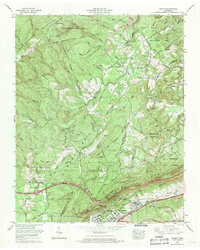
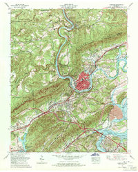 1968 Harriman1971 Print · USGSHarriman and Kingston sit at the junction of the river and rail lines in the late sixties as the TVA system reshaped the valley. Trace family history at Bazel Town Cem, follow the historic Old Walton Road, or locate the Kingston Steam Plant.3 unique versions available
 - 1969 Map of Rockwood, 1971 Print
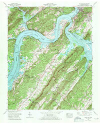
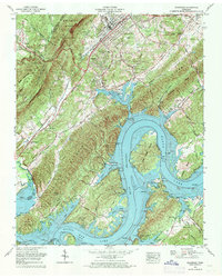 1969 Rockwood1971 Print · USGSThe Tennessee River valley in the late sixties reveals a landscape where historic roads and rail lines meet the rising waters of Watts Bar Lake. Researchers can locate numerous family burial sites like Hinds Cem and ancestral landmarks including Clymersville Ch and Thief Neck Island.4 unique versions available
End of results
Showing maps 1-6 of 6
Top cities near Rockwood
- Fairfield Glade historical maps
- Kingston historical maps
- Harriman historical maps
- Spring City historical maps
- Midtown historical maps
- Crab Orchard historical maps
See more
Top neighborhoods of Rockwood
- Lakemont Heights historical maps
- College Grove historical maps
- Highland Forest historical maps
- Cardiff historical maps
- Dodson historical maps
Frequently asked questions
- What are the different types of historical maps available for Rockwood?
- What is the oldest map of Rockwood?
- Where can I purchase historical maps of Rockwood for my home or office?
- Where can I download high-res historical maps of Rockwood?
- Are there historical topographic maps available for Rockwood?
- Is there historical aerial imagery available for Rockwood?
- Where are historical maps of Rockwood sourced from?