1940s Maps of Dunlap, Tennessee
Explore 8 historic maps of Dunlap from the 1940s. These maps offer a rare glimpse into what life looked like during the 1940s — showing old roads, neighborhoods, homes, and landmarks that have changed or disappeared over time.
Whether you're researching your family's past, planning a metal detecting trip, or studying how Dunlap's landscape evolved across the 1940s, these high-resolution maps are a powerful tool for exploring the history of this region.
- Focus on a specific era: All maps on this page are from the 1940s, giving you a focused view of this time period.
- See what’s changed: Compare century-old streets, trails, and buildings to today's modern landscape using overlays and satellite layers.
- Research with precision: Use these maps for genealogy, historical research, land use analysis, or educational projects.
- View, download, or print: Maps are fully viewable online in high resolution, and can be downloaded or printed for your own records.
Start exploring Dunlap's history through authentic maps from the 1940s. This is your window into the past.
Dunlap, TN maps
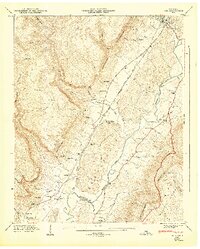
(8)- 1946 Map of Savage Point
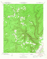 1946 Savage Point1946 Print · USGSThe town of Dunlap and the surrounding heights of the Cumberland Plateau are captured here in the mid-1940s. Genealogists and historians can trace local landmarks like Sequatchie County High Sch, King Cem, and Cagle.4 unique versions available
 - 1946 Map of Henson Gap
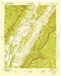
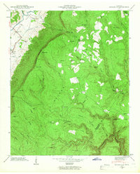 1946 Henson Gap1946 Print · USGSThe Cumberland plateau and Sequatchie valley meet in the mid-1940s at a time of rural reliance on traditional ridge communities. Genealogists and local historians can trace family landmarks like Lewis Chapel, Lewis Cem, and the Alvin C. York Highway.4 unique versions available
 - 1946 Map of Daus, 1956 Print
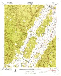 1946 Daus1956 Print · USGSThe Sequatchie Valley is captured just after the war as the mountain and valley economies intertwined. Genealogists and historians can trace family roots through numerous sites like Hatfield Cem, New Hope Ch, and the rail stops at Daus and Dunlap.6 unique versions available
 - 1946 Map of Mount Airy, 1965 Print
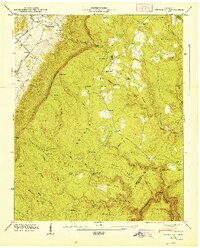
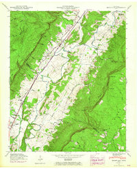 1946 Mount Airy1965 Print · USGSBledsoe County is shown in the mid-1940s, with later revisions capturing the valley's development along the Sequatchie River. Researchers can trace old family sites and rural landmarks like Mount Airy Ch, Collier Cem, and the Brush Creek Siding rail stop.4 unique versions available
 - 1947 Map of Daus
 1947 Daus1947 Print · USGSThe Sequatchie Valley floor and the steep Cumberland Escarpment appear here just after the war, at a peak of rail-and-river connectivity. Researchers can trace family history through a dozen rural landmarks like Stone Cem, Cedar Spring Sch, and Daus.
 - 1947 Map of Henson Gap
 1947 Henson Gap1947 Print · USGSThe Tennessee mountain plateau meets the valley floor just after the war, revealing a landscape of high ridges and isolated homesteads. Genealogists can trace family footprints at Lewis Cem, Davis Chapel, and the community hub at Lewis Chapel Sch.
 - 1947 Map of Mount Airy, 1948 Print
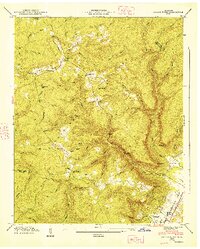
 1947 Mount Airy1948 Print · USGSThe Sequatchie Valley was a vital transport and farming corridor in the late 1940s, hemmed in by the massive Cumberland Escarpment. Genealogists and historians can trace community roots at Mount Airy, Ewtonville, and several family burial grounds like Collier Cem and Hughes Cem.
 - 1947 Map of Savage Point, 1948 Print
 1947 Savage Point1948 Print · USGSThe Sequatchie Valley and Cumberland Plateau meet in this mid-century survey as the town of Dunlap begins its post-war growth. Researchers can trace rural lineages through sites like Lands Chapel, King Cem, and the Sequatchie County High Sch.
End of results
Showing maps 1-8 of 8
Top cities near Dunlap
- Chattanooga historical maps
- Soddy-Daisy historical maps
- Signal Mountain historical maps
- Walden historical maps
- Lakesite historical maps
- Gruetli-Laager historical maps
See more
Top neighborhoods of Dunlap
Frequently asked questions
- What are the different types of historical maps available for Dunlap?
- What is the oldest map of Dunlap?
- Where can I purchase historical maps of Dunlap for my home or office?
- Where can I download high-res historical maps of Dunlap?
- Are there historical topographic maps available for Dunlap?
- Is there historical aerial imagery available for Dunlap?
- Where are historical maps of Dunlap sourced from?