Old Maps of Sevierville, Tennessee for Genealogy
Trace your family roots with 62 historic maps of Sevierville. These high-res maps reveal old neighborhoods, homesites, landmarks, and streets — helping you uncover where your ancestors lived and how the area evolved over time.
- Explore historic neighborhoods: Identify where your relatives may have lived in the 1800s or 1900s.
- Compare maps over time: Trace the changes in streets, buildings, and landmarks for multi-generational research.
- Perfect for genealogy & ancestry research: Used by family historians and researchers to map out lineage and migration.
These maps are an incredible resource for exploring your personal connection to Sevierville's past.
Sevierville, TN maps
(62)- 1886 Map of Knoxville
 1886 Knoxville1886 Print · USGSEast Tennessee in the late nineteenth century was a landscape of river ferries and mountain coves centered around the growing hub of Knoxville. Genealogists can locate family landmarks like Spencer Cabin, Montvale Springs, and the old Brabsons Ferry river crossing.
 - 1892 Map of Knoxville
 1892 Knoxville1892 Print · USGSEastern Tennessee in the late nineteenth century shows a landscape of river-valley commerce transitioning into the Great Smokies. Genealogists can trace early homesteads near Sevierville or locate landmarks like Porter Academy and Boyd Ferry.
 - 1893 Map of Mt Guyot
 1893 Mt Guyot1893 Print · USGSThe Tennessee and North Carolina borderlands are captured here in the 1890s, when isolated mountain coves and river towns relied on the Virginia and Georgia Railroad. Researchers can trace old family sites and transport routes through Fair Garden, Jones Cove, and along the Elliot Ferry Road.3 unique versions available
 - 1894 Map of Knoxville
 1894 Knoxville1894 Print · USGSThe Tennessee valley meets the high Smokies in the 1890s, revealing a landscape of river ferries, mountain coves, and emerging rail towns. Genealogists and historians can trace early crossings at Boyd Ferry, established schools like Porter Academy, and the early footprints of Gatlinburg and Pigeon Forge.
 - 1895 Map of Knoxville
 1895 Knoxville1895 Print · USGSThe Tennessee and French Broad Rivers converge in this late-nineteenth-century survey of East Tennessee’s rising landscape. Trace the early rail lines and mountain crossings that shaped life for families in Sevierville, Gatlinburg, and Maryville.2 unique versions available
 - 1897 Map of Maynardville
 1897 Maynardville1897 Print · USGSEast Tennessee in the late nineteenth century was a landscape of high ridges and vital river fords. Genealogists and historians can trace old homesteads and transit hubs like Nances Ferry, the Lead Mine at New Prospect, and Massongills Mill.
 - 1900 Map of Maynardville
 1900 Maynardville1900 Print · USGSEast Tennessee was a world of river fords and mountain gaps at the turn of the century, dominated by the winding Clinch and Powell rivers. Genealogists can trace family roots through specific landmarks like Massongills Mill, Church Grove, and Sharps Chapel.4 unique versions available
 - 1901 Map of Knoxville
 1901 Knoxville1901 Print · USGSThe East Tennessee borderlands meet the high Smokies at the turn of the century. Genealogists can trace early homesteads and crossroads near Sevierville and Maryville, or find landmarks like Cade Cove and Gatlinburg before they became tourist hubs.5 unique versions available
 - 1912 Map of Mt Guyot
 1912 Mt Guyot1912 Print · USGSThe Tennessee and North Carolina borderlands come into focus in the early twentieth century, prior to the creation of the Great Smoky Mountains National Park. Trace ancestral locations like Cataloochee and Smokemont or follow the Southern RR to Newport.5 unique versions available
 - 1935 Map of English Mountain
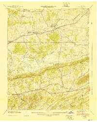
 1935 English Mountain1935 Print · USGSSevier County and the foothills of the Smokies are seen here during the mid-thirties as the national park was taking shape. Genealogists can trace family roots through scores of rural institutions like Smoky Mtn Academy, Pittman Center, and the Crockettville Sch.
 - 1935 Map of Straw Plains
 1935 Straw Plains1935 Print · USGSEast Tennessee life in the mid-1930s is centered on the winding Holston River and the bustling Southern railroad corridor. Researchers can trace family roots at Hickle Cem, find the site of Massengale Mill, or locate Indian Cave.
 - 1935 Map of Richardson Cove
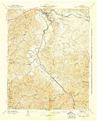
 1935 Richardson Cove1935 Print · USGSSevier County communities appear here in the mid-1930s, nestled between the ridgelines of the Great Smokies. Genealogists can trace family landmarks and schools including Smoky Mtn Academy, Richardson Cove, and Oldham.
 - 1935 Map of New Market
 1935 New Market1935 Print · USGSJefferson County was undergoing significant modernization in the mid-1930s as the Tennessee Valley Authority mapped its growing infrastructure. Researchers can trace old family sites and industrial history through Dinwoody Mill, the SOUTHERN rail stops at Friends Station, and the Shrader Chapel Sch.
 - 1935 Map of Sevierville
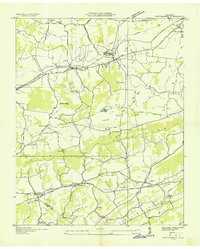
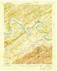
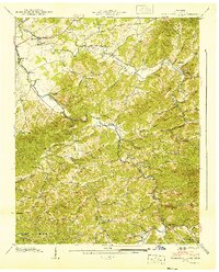
 1935 Sevierville1935 Print · USGSSevier County during the mid-1930s is captured here in transition, showing the river-dependent communities along the French Broad River before modern development. Genealogists and historians can trace early school sites like Seven Islands Sch and old river crossings such as Trundle Ferry.
 - 1935 Map of Boyds Creek
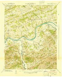
 1935 Boyds Creek1935 Print · USGSEast Tennessee river life comes into focus in the mid-1930s along the winding French Broad River. Genealogists and local historians can trace family roots through numerous rural landmarks like Trundle Crossroads, Boyds Creek Cem, and the Huffaker Ferry.2 unique versions available
 - 1935 Map of Pigeon Forge
 1935 Pigeon Forge1935 Print · USGSSevier County appears in the mid-thirties as a network of river-bottom farms and mountain hollows before the rise of modern tourism. Genealogists can locate family landmarks such as McCooksville, Henderson Springs, and the Williamsburg Sch.
 - 1935 Map of Kykers Ferry
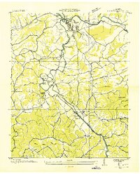
 1935 Kykers Ferry1935 Print · USGSThe French Broad and Little Pigeon rivers meet in this mid-1930s survey of the Sevier and Jefferson county line. Genealogists and historians can trace the locations of Kykers Ferry, the French Broad Academy, and family-named cemeteries like Underwood Cem.
 - 1939 Map of New Market, 1956 Print
 1939 New Market1956 Print · USGSJefferson County was an active landscape of zinc mining and valley farming just before the mid-century. Researchers can trace ancestral locations like Nances Grove, family-run landmarks like French Mill, and local burial sites including Westview Cem.
 - 1940 Map of New Market
 1940 New Market1940 Print · USGSJefferson County's rural and industrial landscape is captured here in the years before the war, centered on the New Market rail corridor. Genealogists and historians can locate family landmarks like Dinwoody Mill, trace the SOUTHERN railroad line, and find old burial grounds such as Caldwell Cem.2 unique versions available
 - 1940 Map of Pigeon Forge
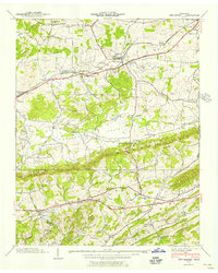
 1940 Pigeon Forge1940 Print · USGSSevier County during the pre-war period shows the early development of Pigeon Forge and the established county seat at Sevierville. Genealogists and historians can trace family locations near Mc Mahan Cem, Henderson Springs, and the Williamsburg Sch.
 - 1940 Map of Boyds Creek
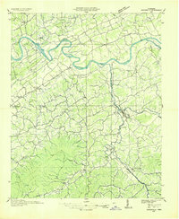
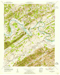
 1940 Boyds Creek1940 Print · USGSThe French Broad River valley of East Tennessee comes alive in the pre-war era, showing a landscape defined by river meanders and mountain ridges. Genealogists can trace family footprints at Trundle Cemetery, the John Sevier Monument, and historic river crossings like Huffaker Ferry.3 unique versions available
 - 1940 Map of Kykers Ferry
 1940 Kykers Ferry1940 Print · USGSThe river-and-road networks of Sevier and Jefferson counties are preserved here just before the mid-century. Genealogists can trace family landmarks and river crossings like KYKERS FERRY, Kodak (P O), and the Oak Grove Cem.2 unique versions available
 - 1940 Map of Richardson Cove
 1940 Richardson Cove1940 Print · USGSSevier County mountain life is captured here in the early 1940s, showing a landscape defined by river-valley settlements and rural academies. Genealogists can trace family footprints through the Smoky Mtn Academy, Boogertown, and the Williams Cem.4 unique versions available
 - 1953 Map of Boyds Creek, 1955 Print
 1953 Boyds Creek1955 Print · USGSThe French Broad River valley at the Sevier and Knox county line was a network of island farms and rural schoolhouses in the early fifties. Genealogists can trace family roots through the John Sevier Monument, Peters Mill, and the Harrison-Chilhowee Academy.3 unique versions available
 - 1955 Map of Knoxville
 1955 Knoxville1955 Print · USGSThe Southern Appalachians and the Smoky Mountains are shown here at a peak of mid-century development and conservation. Genealogists and historians can trace the early road networks connecting Gatlinburg, Waynesville, and the Cherokee Indian Reservation across the high ridges.
Showing maps 1-25 of 62
Top cities near Sevierville
- Knoxville historical maps
- Morristown historical maps
- Jefferson City historical maps
- Pigeon Forge historical maps
- Gatlinburg historical maps
- Mascot historical maps
See more
Top neighborhoods of Sevierville
Frequently asked questions
- What are the different types of historical maps available for Sevierville?
- What is the oldest map of Sevierville?
- Where can I purchase historical maps of Sevierville for my home or office?
- Where can I download high-res historical maps of Sevierville?
- Are there historical topographic maps available for Sevierville?
- Is there historical aerial imagery available for Sevierville?
- Where are historical maps of Sevierville sourced from?