1990s Maps of Sumner County, Tennessee
Explore 5 historic maps of Sumner County from the 1990s. These maps offer a rare glimpse into what life looked like during the 1990s — showing old roads, neighborhoods, homes, and landmarks that have changed or disappeared over time.
Whether you're researching your family's past, planning a metal detecting trip, or studying how Sumner County's landscape evolved across the 1990s, these high-resolution maps are a powerful tool for exploring the history of this region.
- Focus on a specific era: All maps on this page are from the 1990s, giving you a focused view of this time period.
- See what’s changed: Compare century-old streets, trails, and buildings to today's modern landscape using overlays and satellite layers.
- Research with precision: Use these maps for genealogy, historical research, land use analysis, or educational projects.
- View, download, or print: Maps are fully viewable online in high resolution, and can be downloaded or printed for your own records.
Start exploring Sumner County's history through authentic maps from the 1990s. This is your window into the past.
Sumner County, TN maps
(5)- 1994 Map of Bethpage, 1997 Print
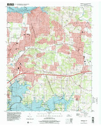
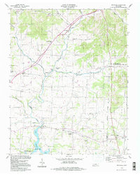 1994 Bethpage1997 Print · USGSSumner and Trousdale counties are shown in the mid-nineties, a period when the rural landscape between Bethpage and Castalian Springs remained largely intact. Researchers can trace the Old Railroad Grade and locate long-standing community landmarks like Old Union Ch and Durham Chapel Sch.
 - 1994 Map of Hartsville, 1997 Print
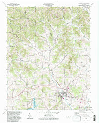 1994 Hartsville1997 Print · USGSHartsville and the surrounding Trousdale County countryside are shown here in the mid-nineties, just north of the Cumberland River. Researchers can trace rural lineages through landmarks like Leaths Chapel, Willow Grove Cem, and the old Ward High Sch.
 - 1994 Map of Cottontown, 1997 Print
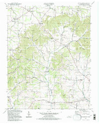 1994 Cottontown1997 Print · USGSSumner County in the mid-nineties remains a landscape of deep family roots and rural crossroads. Researchers can trace historic sites like the Sumner County Home, Fairmont Sch, and numerous family plots such as the Pitt-Bursby Cem.
 - 1994 Map of Hunters Point, 1997 Print
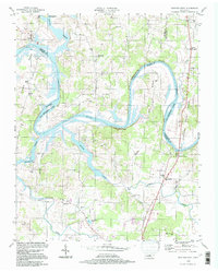 1994 Hunters Point1997 Print · USGSThe Cumberland River loops through Wilson and Sumner counties in the mid-1990s, where old oxbows meet the modern waters of Old Hickory Lake. Researchers can trace early settlements at Cairo and Macedonia, or locate rural landmarks like Carroll Sch and the Nathan J Harsh Bridge.
 - 1997 Map of Hermitage, 2001 Print
 1997 Hermitage2001 Print · USGSThe suburbs east of Nashville were rapidly evolving in the late nineties as legacy estates met modern reservoirs. Genealogists and historians can trace the grounds of The Hermitage, locate the Mount Juliet Cem, and explore the shoreline of Old Hickory Lake.
End of results
Showing maps 1-5 of 5
Top cities of Sumner County
- Hendersonville historical maps
- Gallatin historical maps
- Portland historical maps
- Millersville historical maps
- Westmoreland historical maps
- Mitchellville historical maps
Frequently asked questions
- What are the different types of historical maps available for Sumner County?
- What is the oldest map of Sumner County?
- Where can I purchase historical maps of Sumner County for my home or office?
- Where can I download high-res historical maps of Sumner County?
- Are there historical topographic maps available for Sumner County?
- Is there historical aerial imagery available for Sumner County?
- Where are historical maps of Sumner County sourced from?