1960s Maps of Millersville, Tennessee
Explore 2 historic maps of Millersville from the 1960s. These maps offer a rare glimpse into what life looked like during the 1960s — showing old roads, neighborhoods, homes, and landmarks that have changed or disappeared over time.
Whether you're researching your family's past, planning a metal detecting trip, or studying how Millersville's landscape evolved across the 1960s, these high-resolution maps are a powerful tool for exploring the history of this region.
- Focus on a specific era: All maps on this page are from the 1960s, giving you a focused view of this time period.
- See what’s changed: Compare century-old streets, trails, and buildings to today's modern landscape using overlays and satellite layers.
- Research with precision: Use these maps for genealogy, historical research, land use analysis, or educational projects.
- View, download, or print: Maps are fully viewable online in high resolution, and can be downloaded or printed for your own records.
Start exploring Millersville's history through authentic maps from the 1960s. This is your window into the past.
Millersville, TN maps
(2)- 1961 Map of Greenbrier, 1963 Print
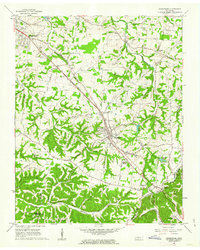 1961 Greenbrier1963 Print · USGSRobertson County's rail-and-road corridor comes alive in the early sixties as communities grew along the Louisville and Nashville line. Genealogists can trace family landmarks like the Bloodworth Cem, Lights Chapel Cem, and Hygeia Springs.3 unique versions available
 - 1968 Map of Goodlettsville, 1971 Print
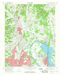 1968 Goodlettsville1971 Print · USGSThe northern suburbs of Nashville were rapidly evolving in the late sixties as the Cumberland River landscape was reshaped. Researchers can find many family landmarks, from Lutons Chapel and Old Center Ch to the rail siding at Amqui.4 unique versions available
End of results
Showing maps 1-2 of 2
Top cities near Millersville
- Nashville historical maps
- Hendersonville historical maps
- Gallatin historical maps
- North Nashville historical maps
- Goodlettsville historical maps
- Springfield historical maps
See more
Top neighborhoods of Millersville
Frequently asked questions
- What are the different types of historical maps available for Millersville?
- What is the oldest map of Millersville?
- Where can I purchase historical maps of Millersville for my home or office?
- Where can I download high-res historical maps of Millersville?
- Are there historical topographic maps available for Millersville?
- Is there historical aerial imagery available for Millersville?
- Where are historical maps of Millersville sourced from?