1940s Maps of Union County, Tennessee
Explore 9 historic maps of Union County from the 1940s. These maps offer a rare glimpse into what life looked like during the 1940s — showing old roads, neighborhoods, homes, and landmarks that have changed or disappeared over time.
Whether you're researching your family's past, planning a metal detecting trip, or studying how Union County's landscape evolved across the 1940s, these high-resolution maps are a powerful tool for exploring the history of this region.
- Focus on a specific era: All maps on this page are from the 1940s, giving you a focused view of this time period.
- See what’s changed: Compare century-old streets, trails, and buildings to today's modern landscape using overlays and satellite layers.
- Research with precision: Use these maps for genealogy, historical research, land use analysis, or educational projects.
- View, download, or print: Maps are fully viewable online in high resolution, and can be downloaded or printed for your own records.
Start exploring Union County's history through authentic maps from the 1940s. This is your window into the past.
Union County, TN maps
(9)- 1941 Map of Big Ridge Park
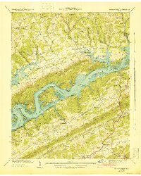
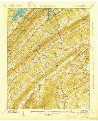 1941 Big Ridge Park1941 Print · USGSIn the early 1940s, the valleys of Union and Knox Counties were undergoing profound change as the Norris Reservoir rose. Researchers can trace ancestral landmarks like New Loyston Cem, Stokes Mill, and schools such as Arevalo Sch.
 - 1941 Map of White Hollow
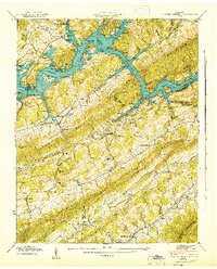
 1941 White Hollow1941 Print · USGSUnion County is seen here during the early years of the Norris Reservoir, when newly formed shorelines met established ridge-top communities. Genealogists can locate family sites like Mc Carty Cem, study the Mt Olive Sch, or find the Hickory Star Landing riverfront.
 - 1941 Map of Graveston
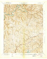
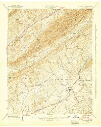 1941 Graveston1941 Print · USGSNortheast of Knoxville in the early 1940s, these ridge-and-valley communities remained oriented around local schools and the Southern railroad line. Genealogists can trace family landmarks like Ailor Cem, the Graveston Mill Pond, and Little Flat Creek Ch.2 unique versions available
 - 1941 Map of Demory
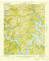 1941 Demory1941 Print · USGSIn the early 1940s, the Powell and Clinch River valleys were undergoing a massive transformation as the Norris Reservoir reached its early extent. Genealogists can locate family landmarks like Baker Forge Memorial Cem and Woodward Cem near the settlements of Demory and Grantsboro.2 unique versions available
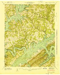
 - 1941 Map of Maynardville
 1941 Maynardville1941 Print · USGSUnion County during the transformative early years of the TVA project shows a landscape of traditional settlements meeting new infrastructure. Researchers can trace family history at the Berry Peters Mill, Sharps Chapel, and dozens of burial sites like Lay Cem and Tharp Cem.
 - 1942 Map of Ausmus
 1942 Ausmus1942 Print · USGSThe foothills of the Clinch River basin in the early 1940s show a landscape newly shaped by the Norris Reservoir. Researchers can trace ancestral roots through dozens of family landmarks like Ausmus Cem, Moyers Cem, and Russell Mill.
 - 1942 Map of Well Spring
 1942 Well Spring1942 Print · USGSIn the early 1940s, this portion of the Powell River valley was being reshaped by the rising Norris Reservoir. Genealogists can trace numerous family landmarks like Parrott Cem and Childress Cem, alongside local centers like Speedwell Academy.
 - 1942 Map of Clouds
 1942 Clouds1942 Print · USGSClaiborne and Union counties are shown in the early 1940s as the Norris Reservoir and Powell River shape the landscape. Researchers can trace family sites like Meyers Mill, Moody Chapel, and several local schools like Lily Grove Sch.3 unique versions available
 - 1942 Map of Powder Springs
 1942 Powder Springs1942 Print · USGSEast Tennessee life in the early 1940s is captured here as the waters of Norris Reservoir reshaped the valley. Researchers can trace family ties at Butcher Cem, Zion Ch, or the Navehill Sch during this era of TVA transformation.
End of results
Showing maps 1-9 of 9
Top cities of Union County
Frequently asked questions
- What are the different types of historical maps available for Union County?
- What is the oldest map of Union County?
- Where can I purchase historical maps of Union County for my home or office?
- Where can I download high-res historical maps of Union County?
- Are there historical topographic maps available for Union County?
- Is there historical aerial imagery available for Union County?
- Where are historical maps of Union County sourced from?