1950s Maps of Union County, Tennessee
Explore 14 historic maps of Union County from the 1950s. These maps offer a rare glimpse into what life looked like during the 1950s — showing old roads, neighborhoods, homes, and landmarks that have changed or disappeared over time.
Whether you're researching your family's past, planning a metal detecting trip, or studying how Union County's landscape evolved across the 1950s, these high-resolution maps are a powerful tool for exploring the history of this region.
- Focus on a specific era: All maps on this page are from the 1950s, giving you a focused view of this time period.
- See what’s changed: Compare century-old streets, trails, and buildings to today's modern landscape using overlays and satellite layers.
- Research with precision: Use these maps for genealogy, historical research, land use analysis, or educational projects.
- View, download, or print: Maps are fully viewable online in high resolution, and can be downloaded or printed for your own records.
Start exploring Union County's history through authentic maps from the 1950s. This is your window into the past.
Union County, TN maps
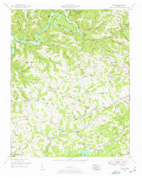
(14)- 1952 Map of Demory
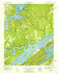
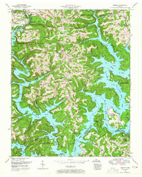 1952 Demory1952 Print · USGSThe confluence of the Clinch and Powell Rivers in Campbell County is shown here following the creation of Norris Lake. Genealogists and local historians can locate dozens of family burial grounds and rural institutions like the Baker Forge Memorial Cemetery, Grantsboro Cemetery, and Demory Church.4 unique versions available
 - 1952 Map of Luttrell, 1954 Print
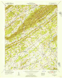
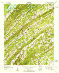
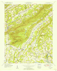 1952 Luttrell1954 Print · USGSNortheast of Knoxville in the early fifties, this area shows a landscape defined by the ridgelines of Clinch Mountain and the Holston River. Researchers can trace numerous family cemeteries and local institutions such as Cedar Ford Church, Lea Springs, and the Southern railroad line.4 unique versions available
 - 1952 Map of Maynardville, 1954 Print
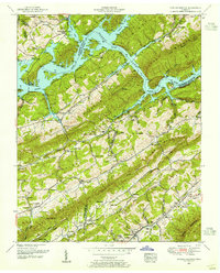
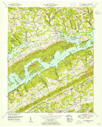 1952 Maynardville1954 Print · USGSMaynardville and the surrounding Tennessee valleys are captured here during the early 1950s, a time when the landscape was adapting to the creation of NORRIS LAKE. Genealogists and historians can trace family roots through numerous sites like the Berry-Peters Mill, Ellisons Store, and the Pleasant View Church.3 unique versions available
 - 1952 Map of Ausmus, 1954 Print
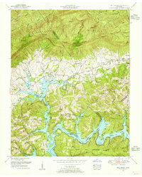
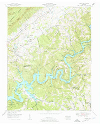 1952 Ausmus1954 Print · USGSClaiborne and Union counties are shown in the early fifties as the Powell River reaches the waters of Norris Lake. Genealogists and historians can trace scores of family burial grounds and landmarks like Speedwell, Collins Mill, and Rush Strong School.4 unique versions available
 - 1952 Map of Clouds, 1954 Print
 1952 Clouds1954 Print · USGSClaiborne County's ridge-and-hollow country is captured here in the early fifties as the Powell River and Norris Lake define the landscape. Local historians can trace family roots through numerous landmarks like Lonesome Valley School, New Hope Church, and Sandlick.4 unique versions available
 - 1952 Map of Graveston, 1954 Print
 1952 Graveston1954 Print · USGSUnion and Knox Counties are shown in the early fifties as the rural landscape of East Tennessee maintained its tight-knit network of ridge-side farms and rail-line towns. Genealogists can trace family names across dozens of sites like the Alder Springs Cemetery, Bullrun School, and the community of Corryton.4 unique versions available
 - 1952 Map of Powder Springs, 1955 Print
 1952 Powder Springs1955 Print · USGSTucked between the parallel ridges of East Tennessee in the early fifties, this area shows a landscape shaped by the Clinch River and new lakeside developments. Local researchers can locate dozens of family burial grounds and country steeples, including Hammock Cemetery, Pennington Chapel, and the Walker Ford Lookout Tower.3 unique versions available
 - 1952 Map of Well Spring, 1955 Print
 1952 Well Spring1955 Print · USGSLife along the Powell River in the early fifties is preserved here, as rural communities adjusted to the presence of Norris Lake. Genealogists can trace family names through dozens of sites like Well Spring Cemetery, Cawood School, and Hayes Cemetery.4 unique versions available
 - 1952 Map of White Hollow, 1955 Print
 1952 White Hollow1955 Print · USGSSurrounding the intricate fingers of Norris Lake in the early 1950s, this area shows a landscape transformed by water and conservation. Researchers can trace dozens of family-named landmarks and cemeteries like Lays Cemetery and New Mossy Spring Cemetery near Lindamood.4 unique versions available
 - 1952 Map of Big Ridge Park, 1955 Print
 1952 Big Ridge Park1955 Print · USGSThe ridge-and-valley country of East Tennessee is captured here in the early fifties as the reservoir era matured. Genealogists and local historians can trace family ties through New Loyston Cemetery, Arevilo School, and the settlements of Paulette and Warwicktown.3 unique versions available
 - 1955 Map of Johnson City
 1955 Johnson City1955 Print · USGSEast Tennessee and the bordering highlands of Virginia and Kentucky appear here during the post-war industrial boom. You can trace the complex network of mountain ridges and new TVA lakes, from Johnson City to the coalfields near Middlesboro and Lynch.
 - 1956 Map of Corbin, 1966 Print
 1956 Corbin1966 Print · USGSThe Kentucky and Tennessee borderlands are captured here in the mid-fifties, showing the region's shift toward modern interstate travel and reservoir development. Genealogists and historians can trace old community lines near Albany and Monticello or locate early rail junctions along the Southern and Tennessee Central lines.3 unique versions available
 - 1957 Map of Johnson City, 1966 Print
 1957 Johnson City1966 Print · USGSUpper East Tennessee and Southwest Virginia are shown here during the mid-sixties transition of the Appalachians. Researchers can trace the industrial rail hubs of Kingsport, the sprawling waters of Cherokee Lake, and the historic Cumberland Gap.
 - 1958 Map of Corbin
 1958 Corbin1958 Print · USGSThe Upper Cumberland borderlands appear in the late 1950s as massive reservoirs and early atomic-era growth reshape the region. Trace family roots and vanished landmarks near Lake Cumberland, Oak Ridge, and the Cumberland National Forest.
End of results
Showing maps 1-14 of 14
Top cities of Union County
Frequently asked questions
- What are the different types of historical maps available for Union County?
- What is the oldest map of Union County?
- Where can I purchase historical maps of Union County for my home or office?
- Where can I download high-res historical maps of Union County?
- Are there historical topographic maps available for Union County?
- Is there historical aerial imagery available for Union County?
- Where are historical maps of Union County sourced from?