1930s Maps of Mill Brook, Tennessee
Explore 3 historic maps of Mill Brook from the 1930s. These maps offer a rare glimpse into what life looked like during the 1930s — showing old roads, neighborhoods, homes, and landmarks that have changed or disappeared over time.
Whether you're researching your family's past, planning a metal detecting trip, or studying how Mill Brook's landscape evolved across the 1930s, these high-resolution maps are a powerful tool for exploring the history of this region.
- Focus on a specific era: All maps on this page are from the 1930s, giving you a focused view of this time period.
- See what’s changed: Compare century-old streets, trails, and buildings to today's modern landscape using overlays and satellite layers.
- Research with precision: Use these maps for genealogy, historical research, land use analysis, or educational projects.
- View, download, or print: Maps are fully viewable online in high resolution, and can be downloaded or printed for your own records.
Start exploring Mill Brook's history through authentic maps from the 1930s. This is your window into the past.
Mill Brook, TN maps
(3)- 1935 Map of Fall Branch
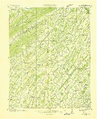 1935 Fall Branch1935 Print · USGSNortheast Tennessee in the mid-thirties shows a rural landscape of ridges and crossroads at the junction of four counties. Trace family history through dozens of local landmarks like Kincheloe Mill, Evening Star Sch, and Cedar Chapel.
 - 1935 Map of Jearoldstown
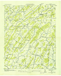 1935 Jearoldstown1935 Print · USGSGreene County settlement and Tennessee Valley utility expansion are captured here in the mid-1930s. Genealogists can trace family names at Dixon Chapel, Union Temple Ch, and the rural community of Milburton.
 - 1939 Map of Jearoldstown
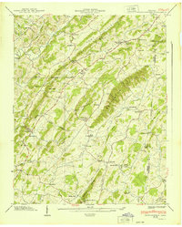 1939 Jearoldstown1939 Print · USGSGreene County, Tennessee, is captured here in the late 1930s, showing a rural landscape of ridges and hollows before the mid-century. You can trace early family homesites near Jearoldstown, locate old mills like Eagle Mill, and find vanished country schools such as Milburton Sch.3 unique versions available
End of results
Showing maps 1-3 of 3
Top cities near Mill Brook
- Johnson City historical maps
- Kingsport historical maps
- Greeneville historical maps
- Erwin historical maps
- Jonesborough historical maps
- Oak Grove historical maps
See more
Frequently asked questions
- What are the different types of historical maps available for Mill Brook?
- What is the oldest map of Mill Brook?
- Where can I purchase historical maps of Mill Brook for my home or office?
- Where can I download high-res historical maps of Mill Brook?
- Are there historical topographic maps available for Mill Brook?
- Is there historical aerial imagery available for Mill Brook?
- Where are historical maps of Mill Brook sourced from?