1930s Maps of Washington College, Tennessee
Explore 2 historic maps of Washington College from the 1930s. These maps offer a rare glimpse into what life looked like during the 1930s — showing old roads, neighborhoods, homes, and landmarks that have changed or disappeared over time.
Whether you're researching your family's past, planning a metal detecting trip, or studying how Washington College's landscape evolved across the 1930s, these high-resolution maps are a powerful tool for exploring the history of this region.
- Focus on a specific era: All maps on this page are from the 1930s, giving you a focused view of this time period.
- See what’s changed: Compare century-old streets, trails, and buildings to today's modern landscape using overlays and satellite layers.
- Research with precision: Use these maps for genealogy, historical research, land use analysis, or educational projects.
- View, download, or print: Maps are fully viewable online in high resolution, and can be downloaded or printed for your own records.
Start exploring Washington College's history through authentic maps from the 1930s. This is your window into the past.
Washington College, TN maps
(2)- 1936 Map of Telford
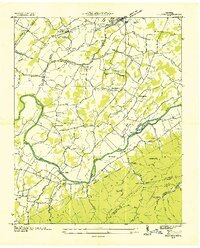 1936 Telford1936 Print · USGSIn the mid-1930s, the Nolichucky River valley supported a landscape of water-powered industry and mountain mining. Genealogists can trace family names through landmarks like Washington College, Broylesville Mill, and the Peach Orchard Mine.
 - 1939 Map of Telford
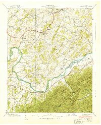 1939 Telford1939 Print · USGSThe Nolichucky River valley in the late 1930s reveals a landscape of established colleges and river-bend farms before modern development. Genealogists can trace family landmarks and rural centers like Washington College, Telford, and the Peach Orchard Mine.4 unique versions available
End of results
Showing maps 1-2 of 2
Top cities near Washington College
- Johnson City historical maps
- Kingsport historical maps
- Greeneville historical maps
- Erwin historical maps
- Jonesborough historical maps
- Oak Grove historical maps
See more
Frequently asked questions
- What are the different types of historical maps available for Washington College?
- What is the oldest map of Washington College?
- Where can I purchase historical maps of Washington College for my home or office?
- Where can I download high-res historical maps of Washington College?
- Are there historical topographic maps available for Washington College?
- Is there historical aerial imagery available for Washington College?
- Where are historical maps of Washington College sourced from?