1930s Maps of Clifton, Tennessee
Explore 4 historic maps of Clifton from the 1930s. These maps offer a rare glimpse into what life looked like during the 1930s — showing old roads, neighborhoods, homes, and landmarks that have changed or disappeared over time.
Whether you're researching your family's past, planning a metal detecting trip, or studying how Clifton's landscape evolved across the 1930s, these high-resolution maps are a powerful tool for exploring the history of this region.
- Focus on a specific era: All maps on this page are from the 1930s, giving you a focused view of this time period.
- See what’s changed: Compare century-old streets, trails, and buildings to today's modern landscape using overlays and satellite layers.
- Research with precision: Use these maps for genealogy, historical research, land use analysis, or educational projects.
- View, download, or print: Maps are fully viewable online in high resolution, and can be downloaded or printed for your own records.
Start exploring Clifton's history through authentic maps from the 1930s. This is your window into the past.
Clifton, TN maps
(4)- 1936 Map of Eagle Creek
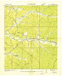 1936 Eagle Creek1936 Print · USGSThe Tennessee borderlands of Wayne and Hardin Counties appear in the mid-1930s as a landscape of rural schoolhouses and family hollows. Researchers can trace the community life of the era through sites like Shady Grove Sch, Bethany Ch, and Old Mill Spring.
 - 1936 Map of Olivehill
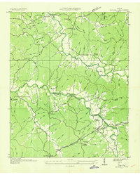 1936 Olivehill1936 Print · USGSHardin County and Wayne County meet along the ridges of the Tennessee Valley during the mid-1930s. Genealogists can trace family footprints through rural landmarks like Piney Grove, Bethlehem, and schools such as Havana Sch and Hannah Sch.
 - 1936 Map of Bath Springs
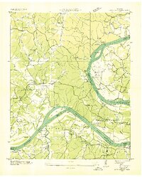 1936 Bath Springs1936 Print · USGSThe Tennessee River valley in the mid-1930s was a landscape defined by its river landings and rural crossroads. You can trace dozens of historic river access points like Furnace Landing and Jeter Landing alongside local landmarks like Bath Springs Ch.
 - 1936 Map of Clifton
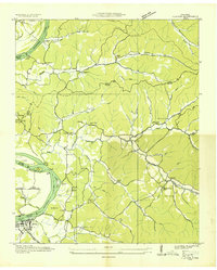 1936 Clifton1936 Print · USGSThe Tennessee River corridor around Clifton was a network of active landings and rural ridge communities during the mid-1930s. Researchers can trace ancestral locations through several family-named cemeteries like Tucker Cem and Prater Cem, or map old river crossings such as Clifton Ferry.
End of results
Showing maps 1-4 of 4
Top cities near Clifton
- Savannah historical maps
- Waynesboro historical maps
- Linden historical maps
- Decaturville historical maps
- Saltillo historical maps
Frequently asked questions
- What are the different types of historical maps available for Clifton?
- What is the oldest map of Clifton?
- Where can I purchase historical maps of Clifton for my home or office?
- Where can I download high-res historical maps of Clifton?
- Are there historical topographic maps available for Clifton?
- Is there historical aerial imagery available for Clifton?
- Where are historical maps of Clifton sourced from?