1960s Maps of Amarillo, Texas
Explore 3 historic maps of Amarillo from the 1960s. These maps offer a rare glimpse into what life looked like during the 1960s — showing old roads, neighborhoods, homes, and landmarks that have changed or disappeared over time.
Whether you're researching your family's past, planning a metal detecting trip, or studying how Amarillo's landscape evolved across the 1960s, these high-resolution maps are a powerful tool for exploring the history of this region.
- Focus on a specific era: All maps on this page are from the 1960s, giving you a focused view of this time period.
- See what’s changed: Compare century-old streets, trails, and buildings to today's modern landscape using overlays and satellite layers.
- Research with precision: Use these maps for genealogy, historical research, land use analysis, or educational projects.
- View, download, or print: Maps are fully viewable online in high resolution, and can be downloaded or printed for your own records.
Start exploring Amarillo's history through authentic maps from the 1960s. This is your window into the past.
Amarillo, TX maps
(3)- 1960 Map of The Palisades, 1961 Print
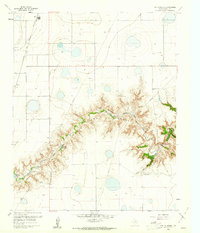 1960 The Palisades1961 Print · USGSRandall County's dramatic canyonlands are shown in detail during the early sixties as the landscape supported both ranching and recreation. Researchers can locate the winding Prairie Dog Town Fork Red River, Camp Harrington, and the railroad stops at Zita and Haney.3 unique versions available
 - 1960 Map of Amarillo West, 1961 Print
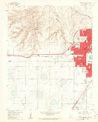 1960 Amarillo West1961 Print · USGSThe Texas Panhandle meets mid-century suburban growth in this survey of West Amarillo during the early 1960s. Researchers can trace the expansion of neighborhood schools like Olsen Park Sch and locate the historic Kiwanis Camp near the rugged breaks of West Amarillo Creek.3 unique versions available
 - 1960 Map of Buffalo Stadium, 1962 Print
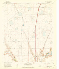 1960 Buffalo Stadium1962 Print · USGSRandall County's dramatic canyon breaks and high plains industry are captured here in the early sixties. Genealogists and local historians can trace the Panhandle and Santa Fe railroad line, locate Haney, or find Memory Gardens (Cem).3 unique versions available
End of results
Showing maps 1-3 of 3
Top cities near Amarillo
- Canyon historical maps
- Lake Tanglewood historical maps
- Timbercreek Canyon historical maps
- Palisades historical maps
- Bishop Hills historical maps
Top neighborhoods of Amarillo
- Dumas Junction historical maps
- Pleasant Valley historical maps
- Pullman historical maps
- Bivins Addition historical maps
- Route 66 Historic District historical maps
Frequently asked questions
- What are the different types of historical maps available for Amarillo?
- What is the oldest map of Amarillo?
- Where can I purchase historical maps of Amarillo for my home or office?
- Where can I download high-res historical maps of Amarillo?
- Are there historical topographic maps available for Amarillo?
- Is there historical aerial imagery available for Amarillo?
- Where are historical maps of Amarillo sourced from?