1980s Maps of Bastrop, Texas
Explore 4 historic maps of Bastrop from the 1980s. These maps offer a rare glimpse into what life looked like during the 1980s — showing old roads, neighborhoods, homes, and landmarks that have changed or disappeared over time.
Whether you're researching your family's past, planning a metal detecting trip, or studying how Bastrop's landscape evolved across the 1980s, these high-resolution maps are a powerful tool for exploring the history of this region.
- Focus on a specific era: All maps on this page are from the 1980s, giving you a focused view of this time period.
- See what’s changed: Compare century-old streets, trails, and buildings to today's modern landscape using overlays and satellite layers.
- Research with precision: Use these maps for genealogy, historical research, land use analysis, or educational projects.
- View, download, or print: Maps are fully viewable online in high resolution, and can be downloaded or printed for your own records.
Start exploring Bastrop's history through authentic maps from the 1980s. This is your window into the past.
Bastrop, TX maps
(4)- 1982 Map of Lake Bastrop
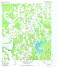 1982 Lake Bastrop1982 Print · USGSBastrop and its northern hinterlands are shown here in the early eighties, as the region balanced its military heritage with growing utility and recreation sectors. Genealogists can locate family sites like Oak Hill Cem, the Greenbriar Free Sch, and the old Sayersville settlement.2 unique versions available
 - 1982 Map of Bastrop
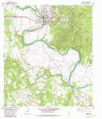 1982 Bastrop1982 Print · USGSBastrop and the Colorado River valley are captured in the early eighties as the town grew alongside its railway and parklands. Family historians can locate several rural burial grounds like Trigg Cem and old church sites including Antioch Ch and Hill Prairie Ch.3 unique versions available
 - 1982 Map of Bastrop SW
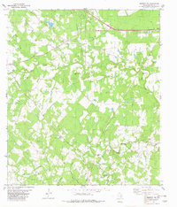 1982 Bastrop SW1982 Print · USGSBastrop County in the early eighties was a landscape of rural family settlements and growing energy production. Genealogists can trace deep local roots at the Alexander-Eldridge Cem, Union Chapel, and the historic crossroads of Cedar Creek.
 - 1985 Map of Austin
 1985 Austin1985 Print · USGSCentral Texas in the mid-eighties reveals a region in transition, balancing rapid urban growth in Austin with deep-rooted rural landscapes. Genealogists and historians can trace family locations near St Johns Ch, the Science Hall schoolhouse, and long-standing communities like Webberville and Manchaca.3 unique versions available
End of results
Showing maps 1-4 of 4
Top cities near Bastrop
- Austin historical maps
- Manor historical maps
- Elgin historical maps
- Smithville historical maps
- Circle D-KC Estates historical maps
- Rosanky historical maps
See more
Top neighborhoods of Bastrop
Frequently asked questions
- What are the different types of historical maps available for Bastrop?
- What is the oldest map of Bastrop?
- Where can I purchase historical maps of Bastrop for my home or office?
- Where can I download high-res historical maps of Bastrop?
- Are there historical topographic maps available for Bastrop?
- Is there historical aerial imagery available for Bastrop?
- Where are historical maps of Bastrop sourced from?