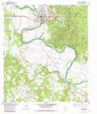
1982 Map of Bastrop
USGS Topo · Published 1982About this map
The Colorado River carves a dramatic path through this central Texas landscape, creating the pronounced Haupt Bend and the Red Bluffs before flowing past Bastrop. The town's late-twentieth-century layout is detailed alongside the Missouri Kansas Texas railroad line, which served as a primary transportation artery for the region. To the east, the terrain rises into the distinctive pine-covered hills of Bastrop State Park, while the southern reaches open into the agricultural expanses of Hills Prairie and Crafts Prairie. This survey is particularly rich for genealogical research, documenting numerous rural burial sites including Burleson Cem, Trigg Cem, and Higgins Cem. Small community centers are anchored by local landmarks such as Antioch Ch and Hill Prairie Ch, reflecting the dispersed settlement patterns that characterize the area outside the main township.
Find a feature on this map
42 named features on this map. Tap any name to fly to it.
Don’t see what you’re looking for? This feature index may not catch every label — zoom into the map to look around manually.
Map Details
Editions of this 1982 Bastrop Map
3 editions found
Other maps of this area

1885 · Bastrop
USGS Topo · 1:125,000

1893 · Bastrop
USGS Topo · 1:125,000

1901 · Flatonia
USGS Topo · 1:125,000

1904 · Bastrop
USGS Topo · 1:125,000

1948 · Smithville
USGS Topo · 1:62,500

1948 · Bastrop
USGS Topo · 1:62,500

1950 · Bastrop
USGS Topo · 1:62,500

1950 · Smithville
USGS Topo · 1:62,500

1953 · Seguin
USGS Topo · 1:250,000

1954 · Austin
USGS Topo · 1:250,000