1960s Maps of Belton, Texas
Explore 3 historic maps of Belton from the 1960s. These maps offer a rare glimpse into what life looked like during the 1960s — showing old roads, neighborhoods, homes, and landmarks that have changed or disappeared over time.
Whether you're researching your family's past, planning a metal detecting trip, or studying how Belton's landscape evolved across the 1960s, these high-resolution maps are a powerful tool for exploring the history of this region.
- Focus on a specific era: All maps on this page are from the 1960s, giving you a focused view of this time period.
- See what’s changed: Compare century-old streets, trails, and buildings to today's modern landscape using overlays and satellite layers.
- Research with precision: Use these maps for genealogy, historical research, land use analysis, or educational projects.
- View, download, or print: Maps are fully viewable online in high resolution, and can be downloaded or printed for your own records.
Start exploring Belton's history through authentic maps from the 1960s. This is your window into the past.
Belton, TX maps
(3)- 1964 Map of Holland, 1966 Print
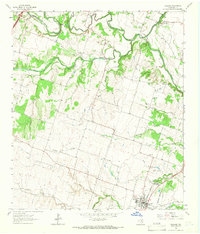 1964 Holland1966 Print · USGSCentral Texas blackland and river bottoms are captured here in the mid-1960s. Genealogists and historians can trace the MISSOURI KANSAS TEXAS rail line, locate Holland Cemetery, or find the historic Sommers Mill.2 unique versions available
 - 1964 Map of Salado, 1966 Print
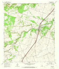 1964 Salado1966 Print · USGSCentral Texas ranching and valley life come into focus in the mid-1960s as the Interstate corridor begins to shape the region. Genealogists can trace family landmarks near Salado, the Willingham Springs Ch, and the rural community of Prairie Dell.3 unique versions available
 - 1965 Map of Belton, 1968 Print
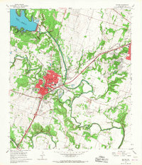 1965 Belton1968 Print · USGSThe Bell County river valleys were transforming in the mid-sixties as the Belton Reservoir stabilized the local waters. Genealogists and researchers can trace the old road to Sparta, find the North Belton Cem, or locate landmarks like the Belton Airfield.3 unique versions available
End of results
Showing maps 1-3 of 3
Top cities near Belton
- Killeen historical maps
- Temple historical maps
- Harker Heights historical maps
- Nolanville historical maps
- Troy historical maps
- Salado historical maps
See more
Top neighborhoods of Belton
Frequently asked questions
- What are the different types of historical maps available for Belton?
- What is the oldest map of Belton?
- Where can I purchase historical maps of Belton for my home or office?
- Where can I download high-res historical maps of Belton?
- Are there historical topographic maps available for Belton?
- Is there historical aerial imagery available for Belton?
- Where are historical maps of Belton sourced from?