Old Maps of Belton, Texas for Metal Detecting
Plan your next treasure hunt with 43 historic maps of Belton. Find old homesites, ghost towns, trails, and gathering spots that may be lost to time — perfect for identifying promising metal detecting locations.
- Locate forgotten sites: Uncover places like long-lost settlements, abandoned rail lines, or gathering spots.
- Plan better hunts: Use map overlays combined with LiDAR or satellite views to narrow in on historically rich areas.
- Made for detectorists: Thousands of hobbyists use these maps to discover relics, coins, and hidden history.
Use these historic maps to boost your research and find new opportunities beneath the surface of Belton.
Belton, TX maps
(43)- 1885 Map of Taylor
 1885 Taylor1885 Print · USGSCentral Texas in the late nineteenth century was a landscape in transition as railroads redefined the old cotton frontier. Genealogists and historians can trace the early growth of rail towns like Taylor and Granger, or find vanished rural outposts such as Ad Hall and Davilla.
 - 1887 Map of Taylor
 1887 Taylor1887 Print · USGSCentral Texas is captured in the late nineteenth century as the railroad began to redefine the blackland prairie. Genealogists can locate early settlements like Davilla and Granger or trace family lands near the San Gabriel River and Taylor.
 - 1892 Map of Temple
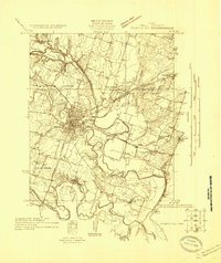
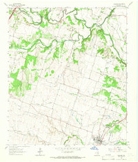
 1892 Temple1892 Print · USGSTexas at the turn of the century shows a landscape defined by emerging railroad junctions and river settlements. Genealogists can trace early homesteads and rail-town growth in Temple, McGregor, and Belton near the banks of the Leon River.6 unique versions available
 - 1893 Map of Georgetown
 1893 Georgetown1893 Print · USGSCentral Texas in the late 1800s was a landscape in flux as rail lines reshaped old frontier settlements. Genealogists can trace the shift from riverside villages like Bagdad and Old Round Rock to new rail hubs such as Leander and Hutto.5 unique versions available
 - 1894 Map of Gatesville
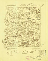
 1894 Gatesville1894 Print · USGSCentral Texas in the late nineteenth century was a landscape of expanding rail lines and established river settlements. Genealogists can trace family names across Pidcock Ranch, Fort Gates, and Coperas Cove, while following the path of the St. Louis Arkansas and Texas Railroad.4 unique versions available
 - 1894 Map of Taylor, 1902 Print
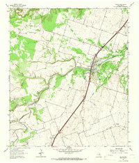
 1894 Taylor1902 Print · USGSCentral Texas at the end of the nineteenth century was a landscape of expanding rail lines and established river settlements. Genealogists and historians can trace the growth of Taylor and Granger, or locate smaller junctions like Ad Hall and Buckholts along the Gulf Colorado and Santa Fe Railroad.4 unique versions available
 - 1924 Map of Gatesville 4-d
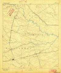
 1924 Gatesville 4-d1924 Print · USGSBell County in the mid-twenties shows a landscape of river-valley homesteads and remote rail sidings along the Leon River. Genealogists can locate several rural community landmarks, including Wiltonville School, Youngsport, and Beren Crossing.
 - 1924 Map of Temple 3-C
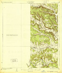
 1924 Temple 3-C1924 Print · USGSBell County at the peak of the rail era shows a landscape where river valleys were the centers of life. Genealogists can locate family landmarks like Rock School, Midway Church, and the winding Meridian Highway.
 - 1930 Map of Killeen
 1930 Killeen1930 Print · USGSBell County was a landscape of small school districts and river crossings in the early thirties. Genealogists can trace family roots through rural landmarks like Keyes Valley Sch, Youngsport, and the Santa Fe line at Stone Siding.2 unique versions available
 - 1931 Map of Belton, 1949 Print
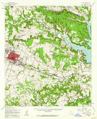
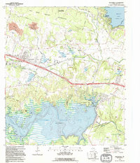
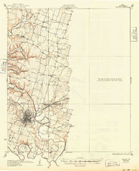 1931 Belton1949 Print · USGSBell County in the 1920s and 30s reveals a landscape of river-valley farming and bustling railroad junctions centered on the county seat. Genealogists and historians can trace early community life through numerous rural landmarks like Moffat Sch, Tennessee Valley Ch, and the Belton and Temple Electric R R.
 - 1947 Map of Killeen, 1953 Print
 1947 Killeen1953 Print · USGSBell and Coryell Counties appear here in the years following the war, showcasing the early growth of Killeen and the Fort Hood Military Reservation. Local historians can trace vanished schoolhouses and churches like Union Hill Sch and McDowell Ch alongside the Gulf Colorado and Santa Fe line.
 - 1947 Map of Nolanville, 1953 Print
 1947 Nolanville1953 Print · USGSNolanville and the surrounding Bell County ranchlands are captured here in the late 1940s as the rail and river networks shaped the local economy. Researchers can trace rural landmarks including Union Grove Sch, Burris Cem, and the path of the Gulf Colorado and Santa Fe railroad.
 - 1954 Map of Waco, 1964 Print
 1954 Waco1964 Print · USGSCentral Texas during the mid-fifties shows a landscape defined by the expansion of Fort Hood Military Reservation and the Brazos river system. Trace the rail lines and early airfields like James Connally Air Force Base and settlements like Temple or McGregor.2 unique versions available
 - 1954 Map of Austin, 1964 Print
 1954 Austin1964 Print · USGSCentral Texas is captured during a period of steady growth as the capital city and its neighboring farm towns began to modernize. Researchers can trace historic rail corridors like the Southern Pacific RR or locate landmarks such as Bergstrom Air Force Base and Pilot Knob.4 unique versions available
 - 1955 Map of Waco
 1955 Waco1955 Print · USGSCentral Texas at the peak of the Cold War reveals a landscape defined by military expansion and major water projects. Researchers can trace the footprints of Fort Hood, the waters of Lake Waco, and regional hubs like Temple or Mexia.
 - 1958 Map of Nolanville, 1961 Print
 1958 Nolanville1961 Print · USGSBell County, Texas, is captured here in the late fifties as the local economy balanced ranching, rail, and military growth. Researchers can locate numerous family burial grounds like Gotcher Cem or trace the early paths of the Gulf Colorado and Santa Fe railroad.3 unique versions available
 - 1958 Map of Killeen, 1962 Print
 1958 Killeen1962 Print · USGSBell County in the late fifties shows a landscape in transition as the military presence at Fort Hood grows alongside established rail towns. Genealogists can trace early rural life through Pleasant Hill Cem, Keys Valley Ch, and the original streets of Nolanville.
 - 1964 Map of Holland, 1966 Print
 1964 Holland1966 Print · USGSCentral Texas blackland and river bottoms are captured here in the mid-1960s. Genealogists and historians can trace the MISSOURI KANSAS TEXAS rail line, locate Holland Cemetery, or find the historic Sommers Mill.2 unique versions available
 - 1964 Map of Salado, 1966 Print
 1964 Salado1966 Print · USGSCentral Texas ranching and valley life come into focus in the mid-1960s as the Interstate corridor begins to shape the region. Genealogists can trace family landmarks near Salado, the Willingham Springs Ch, and the rural community of Prairie Dell.3 unique versions available
 - 1965 Map of Belton, 1968 Print
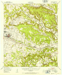
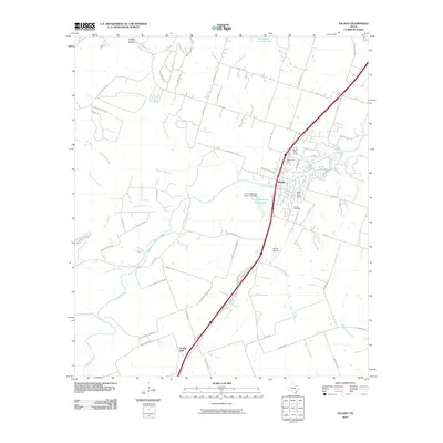
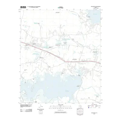
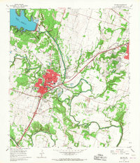 1965 Belton1968 Print · USGSThe Bell County river valleys were transforming in the mid-sixties as the Belton Reservoir stabilized the local waters. Genealogists and researchers can trace the old road to Sparta, find the North Belton Cem, or locate landmarks like the Belton Airfield.3 unique versions available
 - 1985 Map of Temple
 1985 Temple1985 Print · USGSCentral Texas in the mid-eighties shows a landscape of massive defense installations and deep-rooted farming communities. Genealogists and historians can trace the development of Temple and Gatesville, locate the Gatesville State School for Boys, or explore rural outposts like Zabcikville and Westphalia.2 unique versions available
 - 1985 Map of Taylor, 1986 Print
 1985 Taylor1986 Print · USGSWilliamson and Bell counties in the mid-eighties reveal a landscape where the cattle and cotton economy met burgeoning rail infrastructure. Genealogists and historians can trace the paths of the Missouri Pacific railroad through unique hamlets like Ding Dong, Frame Switch, and Beyersville.2 unique versions available
 - 1995 Map of Nolanville
 1995 Nolanville1995 Print · USGSBell County was a landscape of military boundaries and major reservoirs during the mid-nineties. You can trace family roots at McDowell Cem, locate Sparta, and see the early footprint of Nolanville before its recent expansion.
 - 2010 Map of Salado, 2010 Print
 2010 Salado2010 Print · USGSCovers Belton, including Salado, Prairie Dell, and other nearby areas
 - 2010 Map of Nolanville, 2010 Print
 2010 Nolanville2010 Print · USGSCovers Belton, including Temple, Harker Heights, and other nearby areas
Showing maps 1-25 of 43
Top cities near Belton
- Killeen historical maps
- Temple historical maps
- Harker Heights historical maps
- Nolanville historical maps
- Troy historical maps
- Salado historical maps
See more
Top neighborhoods of Belton
Frequently asked questions
- What are the different types of historical maps available for Belton?
- What is the oldest map of Belton?
- Where can I purchase historical maps of Belton for my home or office?
- Where can I download high-res historical maps of Belton?
- Are there historical topographic maps available for Belton?
- Is there historical aerial imagery available for Belton?
- Where are historical maps of Belton sourced from?