1990s Maps of Bexar County, Texas
Explore 18 historic maps of Bexar County from the 1990s. These maps offer a rare glimpse into what life looked like during the 1990s — showing old roads, neighborhoods, homes, and landmarks that have changed or disappeared over time.
Whether you're researching your family's past, planning a metal detecting trip, or studying how Bexar County's landscape evolved across the 1990s, these high-resolution maps are a powerful tool for exploring the history of this region.
- Focus on a specific era: All maps on this page are from the 1990s, giving you a focused view of this time period.
- See what’s changed: Compare century-old streets, trails, and buildings to today's modern landscape using overlays and satellite layers.
- Research with precision: Use these maps for genealogy, historical research, land use analysis, or educational projects.
- View, download, or print: Maps are fully viewable online in high resolution, and can be downloaded or printed for your own records.
Start exploring Bexar County's history through authentic maps from the 1990s. This is your window into the past.
Bexar County, TX maps
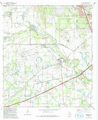
(18)- 1991 Map of Van Raub
 1991 Van Raub1991 Print · USGSThe Texas Hill Country north of San Antonio is captured here in the early nineties, showing a mix of ranch land and growing suburban centers. Researchers can trace historic family sites and early infrastructure near Fair Oaks Ranch, Van Raub, and Robles Cem.
 - 1991 Map of Macdona, 1992 Print
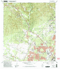
 1991 Macdona1992 Print · USGSBexar County's rural southwest transition is captured here in the early nineties, where the Medina River valley meets expanding military and energy interests. Genealogists and local historians can locate numerous family burial sites like Lessing Cem and Hermann Cem, alongside ranching landmarks like Luckey Ranch.
 - 1992 Map of Marion
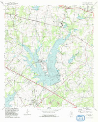
 1992 Marion1992 Print · USGSThe rural corridors and developing towns of Guadalupe and Bexar Counties are captured here in the early nineties. Researchers can trace the Southern Pacific rail line through Marion or locate landmarks like St Paul Church and the Haeckerville community.2 unique versions available
 - 1992 Map of San Antonio East
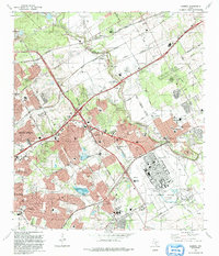
 1992 San Antonio East1992 Print · USGSSan Antonio's eastern landscape in the early nineties shows a significant military and civic footprint during a period of steady urban growth. Genealogists and historians can trace family roots through the National Cemetery, Eastview Cem, and landmarks like Mission Concepcion.
 - 1992 Map of Martinez
 1992 Martinez1992 Print · USGSBexar County's eastern landscape is shown in the early nineties as suburban expansion met established rural settlements. Family historians can trace roots through the St Jerome Ch and Salem Cem, or locate the Martindale Army Airfield.
 - 1992 Map of La Vernia SW
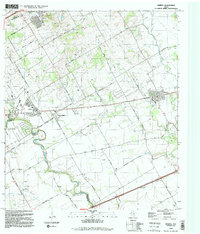
 1992 La Vernia SW1992 Print · USGSWilson County and the Bexar border are shown in the early nineties as a landscape defined by oil production and rural life. Researchers can trace family roots at La Vernia Cem or explore industrial history at the Cooksey Oil Field and Old Railroad Grade.
 - 1992 Map of New Braunfels
 1992 New Braunfels1992 Print · USGSThe San Antonio and New Braunfels corridor was expanding rapidly in the early nineties, balancing heavy military presence with Hill Country recreation. Trace the footprint of CAMP BULLIS MILITARY RESERVATION or locate old railroad stops along the Southern Pacific and Missouri Pacific lines.2 unique versions available
 - 1992 Map of Camp Bullis
 1992 Camp Bullis1992 Print · USGSThe hills north of San Antonio are captured here in the early nineties, showing the intersection of military training grounds and suburban growth. Researchers can trace the Garfes Cem, follow the course of Salado Creek, and locate features within Camp Bullis.
 - 1992 Map of Terrell Wells
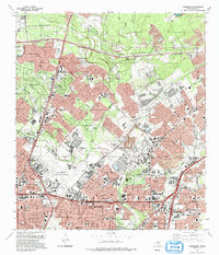
 1992 Terrell Wells1992 Print · USGSSouth San Antonio's transition from military hubs to residential neighborhoods is captured here in the early nineties. Genealogists can trace family roots at Lona China Cem and Garza Crossing or locate early schools like St Clare Sch.2 unique versions available
 - 1992 Map of Southton
 1992 Southton1992 Print · USGSSouthern San Antonio in the early nineties reveals a landscape where colonial history meets modern aviation and industry. Genealogists can locate Mission San Jose, explore the community of Bergs Mill, or trace the Eckert Oil Field.
 - 1992 Map of Saint Hedwig
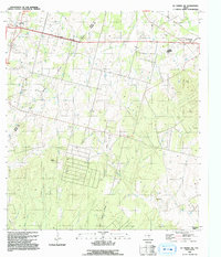
 1992 Saint Hedwig1992 Print · USGSBexar County's rural eastern edge is documented in the early nineties, showing a landscape of creek-side settlements and legacy rail lines. Researchers can trace historic family routes along Graytown Road or locate landmarks like Hebron Ch and Sculls Crossing (Ford).
 - 1992 Map of Schertz
 1992 Schertz1992 Print · USGSThe northeast San Antonio corridor was rapidly urbanizing in the early nineties, centered on the flight lines of Randolph Air Force Base. Genealogists can locate family burial sites at Sahm Cem or Wheeler Cem, while tracing the rail-side growth of Bracken and Selma.
 - 1992 Map of Helotes
 1992 Helotes1992 Print · USGSBexar County experiences rapid suburban transformation in the early nineties as San Antonio expands toward the Hill Country. Genealogists and local historians can trace legacy burial sites like Menchaca Cem and Media Cem or the growth around the University of Texas at San Antonio.2 unique versions available
 - 1992 Map of Longhorn, 1993 Print
 1992 Longhorn1993 Print · USGSNorthern San Antonio was undergoing a dramatic transformation into a suburban hub during the early nineties. Genealogists and local historians can trace the intersection of modern growth and older roots through landmarks like Classen Cem and the Longhorn Siding.2 unique versions available
 - 1992 Map of Castle Hills, 1993 Print
 1992 Castle Hills1993 Print · USGSNorthern Bexar County in the early nineties shows a landscape of rapid suburban growth and institutional expansion. Genealogists and historians can trace neighborhood development alongside local landmarks like Locke Hill Sch, St Francis Ch, and the Olga Site.2 unique versions available
 - 1992 Map of Elmendorf, 1993 Print
 1992 Elmendorf1993 Print · USGSSoutheast of San Antonio in the early nineties, this area shows the intersection of major energy infrastructure and old Texas settlements. Genealogists can locate family sites like Delgado Cem and Flores Cem near the banks of Calaveras Lake.
 - 1993 Map of Culebra Hill
 1993 Culebra Hill1993 Print · USGSWestern Bexar County sees rapid suburban and military expansion during the early nineties. Genealogists and historians can trace the development of Lackland City and Leon Valley or locate the Sociedad Cem and Culebra Hill.2 unique versions available
 - 1993 Map of San Antonio West
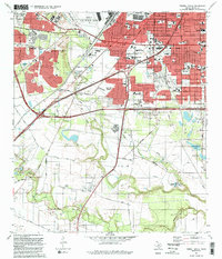
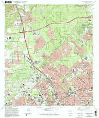
 1993 San Antonio West1993 Print · USGSThe western expansion of the city in the early nineties reveals a landscape defined by military aviation and dense community institutions. Trace the heritage of prominent sites like Our Lady of the Lake University, Lackland Air Force Base, and the historic San Fernando Cem No 2.
End of results
Showing maps 1-18 of 18
Top cities of Bexar County
- San Antonio historical maps
- Universal City historical maps
- Converse historical maps
- Live Oak historical maps
- Leon Valley historical maps
- Lone Oak historical maps
See more
Frequently asked questions
- What are the different types of historical maps available for Bexar County?
- What is the oldest map of Bexar County?
- Where can I purchase historical maps of Bexar County for my home or office?
- Where can I download high-res historical maps of Bexar County?
- Are there historical topographic maps available for Bexar County?
- Is there historical aerial imagery available for Bexar County?
- Where are historical maps of Bexar County sourced from?