Old Maps of Bexar County, Texas for Academic Research
Study the evolution of Bexar County with 236 high-resolution historic maps. Whether you're teaching, researching, or modeling changes in land use, these maps provide essential visual documentation of urban, environmental, and geographic change.
- Analyze long-term change: Track patterns in development, transportation, and natural features.
- Ideal for environmental or urban studies: Support academic projects with primary historical map data.
- Use in the classroom or lab: Educators and researchers rely on these maps to bring historical context to life.
These maps are a powerful tool for teaching, research, and visualizing how Bexar County has changed over the decades.
Bexar County, TX maps
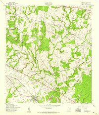
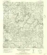
(236)- 1927 Map of New Braunfels
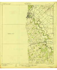 1927 New Braunfels1927 Print · USGSNew Braunfels and the surrounding river valleys are captured here during the mid-twenties, when the regional rail and school networks were at their peak. Genealogists and historians can trace family locations near landmarks like Gaudalupe College, Hortontown Cemetery, and dozens of rural schoolhouses like Austin Hill School.3 unique versions available
 - 1942 Map of Natalia, 1956 Print
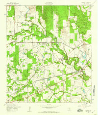
 1942 Natalia1956 Print · USGSMedina and Atascosa Counties are captured here during the mid-century, showing the shift from traditional ranching to an oil and rail economy. Genealogists can trace family holdings and local landmarks such as Bear Creek School, the Sullivan Ranch, and the early settlement at Zig Zag.
 - 1953 Map of Otis Ridge, 1959 Print
 1953 Otis Ridge1959 Print · USGSBexar County ranching and military life intersect in the early fifties among the ridges north of San Antonio. Researchers can trace historic property lines like the Oppenheimer Ranch and military landmarks including Camp Stanley and the Landing Field.
 - 1953 Map of Culebra Hill, 1959 Print
 1953 Culebra Hill1959 Print · USGSBexar County’s rural landscape and expanding military footprint are visible here in the early 1950s. Trace old routes like the Spanish Trail past the Orphanage and the grounds of Culebra Sch and Hoffman Sch.
 - 1953 Map of Schertz, 1959 Print
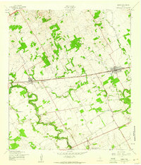
 1953 Schertz1959 Print · USGSThe Texas countryside between San Antonio and Seguin comes alive in the mid-fifties as the rail-and-road network expanded around Randolph Field. Genealogists and historians can trace family-named sites like Davenport Cem, explore the early footprint of Schertz, and locate landmarks such as the Radio Tower (WOAI).
 - 1953 Map of San Antonio West, 1959 Print
 1953 San Antonio West1959 Print · USGSSan Antonio's western suburbs and massive military installations are captured in the early fifties, just as the city's post-war expansion began to accelerate. Genealogists and local historians can trace hundreds of city blocks, dozens of neighborhood schools like Jefferson High Sch, and major landmarks including St Marys University of Texas and Lackland Air Force Base.
 - 1953 Map of Bulverde, 1959 Print
 1953 Bulverde1959 Print · USGSDeep in the Texas Hill Country during the mid-fifties, this area shows a landscape of family-named peaks and small-scale rural life. Genealogists can trace early local sites like St Pauls Cem and St Pauls Ch near the banks of Cibolo Creek.
 - 1953 Map of San Antonio East, 1959 Print
 1953 San Antonio East1959 Print · USGSBexar County at the dawn of the fifties shows the rapid post-war growth of the city and its military installations. Genealogists can trace family plots across the National Cemetery and St Marys Cem or locate old institutions like St Anthonys Junior Seminary.
 - 1953 Map of Bat Cave, 1959 Print
 1953 Bat Cave1959 Print · USGSComal and Bexar counties meet in this mid-century Texas Hill Country survey where railroads and creeks define the landscape. Trace early family landmarks like the Weilbacher Cem, visit the Bracken Ch, or locate the namesake Bat Cave.
 - 1953 Map of Terrell Wells, 1959 Print
 1953 Terrell Wells1959 Print · USGSThe southwest San Antonio suburbs were undergoing rapid mid-century growth as military hubs expanded in the 1950s. Genealogists and historians can trace neighborhood schools like Colliers Sch and the development of Columbia Heights near the sprawling Lackland AFB.
 - 1953 Map of Longhorn, 1959 Print
 1953 Longhorn1959 Print · USGSNorthern San Antonio was a landscape in transition during the early fifties as aviation and modern highways began to reshape rural ranchlands. Genealogists and historians can trace family-named sites like Redland Ranch, Coker Cem, and the Wetmore settlement.
 - 1953 Map of Elmendorf, 1959 Print
 1953 Elmendorf1959 Print · USGSSoutheast of San Antonio in the early fifties, this area shows a landscape defined by the Southern Pacific rail line and active petroleum production. Genealogists can trace family names at the Cantu Cem and Flores Cem or locate the old Parita Ch.
 - 1953 Map of Macdona, 1959 Print
 1953 Macdona1959 Print · USGSBexar County's rural southwest transition is on display in the 1950s as rail lines and military reservations shape the landscape. Genealogists can locate family-named sites like Luckey Ranch or research local congregations at Midway Ch and Sacred Heart Ch.
 - 1953 Map of Southton, 1959 Print
 1953 Southton1959 Print · USGSSouth of San Antonio in the early fifties, the landscape was a mix of historic missions, expanding airfields, and active oil production. Genealogists and historians can trace Southton, the Espada Mission & Cemetery, and the early layout of Brooks Air Force Base.
 - 1953 Map of Helotes, 1959 Print
 1953 Helotes1959 Print · USGSBexar County ranching and early rural development are captured here in the early fifties before the expansion of San Antonio. Researchers can locate the Helotes Sch, Zion Ch, and family landmarks near Government Canyon and Guilbeau.
 - 1953 Map of Castle Hills, 1959 Print
 1953 Castle Hills1959 Print · USGSBexar County landscape is shown here in the mid-fifties as San Antonio's northern suburban growth begins to overtake rural ranch lands. Researchers can trace the development of Castle Hills and Shavano Park alongside legacy sites like Stowers Ranch and the Lockhill Sch.
 - 1953 Map of Martinez, 1959 Print
 1953 Martinez1959 Print · USGSEastern Bexar County at the dawn of the fifties shows a landscape shaped by historical trails and strategic military aviation. Researchers can trace the development of China Grove and Martinez or locate the Martindale National Guard Airfield.
 - 1953 Map of Van Raub, 1959 Print
 1953 Van Raub1959 Print · USGSBexar County ranch land and military outposts are detailed here in the early fifties. Genealogists can locate the Lower Balcones Sch, trace the Southern Pacific line near Van Raub, and find family sites near Leon Springs.
 - 1954 Map of San Antonio, 1964 Print
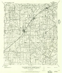
 1954 San Antonio1964 Print · USGSSan Antonio and the Texas Hill Country are captured here in the mid-fifties, showing a landscape defined by massive military air bases and the rising Canyon Reservoir. Trace family ties through historic rail towns like D'Hanis and Castroville or explore the Cold War footprint of Lackland AFB and Randolph AFB.3 unique versions available
 - 1956 Map of Medina Lake
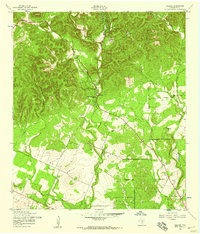
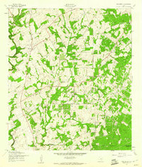
 1956 Medina Lake1956 Print · USGSMedina Lake and the surrounding Texas highlands are captured here in the 1920s and early 1930s. Genealogists and local historians can trace family properties like Kallison Ranch and the Granieri Hotel, or locate landmarks such as the Mico P.O. and Toll Gate.
 - 1957 Map of Boerne
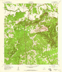
 1957 Boerne1957 Print · USGSThe Texas Hill Country around the mid-century shows a network of family ranch-lands and rural schoolhouses. Genealogists can trace family homesteads like E Fischer or Zoeller and locate historic sites such as Cascade Cavern and Bergheim Cemetery.
 - 1957 Map of San Antonio
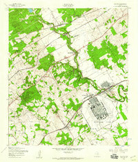
 1957 San Antonio1957 Print · USGSSan Antonio and the Texas Hill Country are shown here during the mid-fifties, capturing the region's expanding post-war military and transportation footprint. Genealogists and local historians can trace the early residential boundaries of Alamo Heights or locate rural landmarks like St Hedwig and Medina Lake.
 - 1957 Map of New Berlin, 1961 Print
 1957 New Berlin1961 Print · USGSGuadalupe County rural life in the late fifties was a mix of quiet farming communities and active oil exploration. Genealogists can locate family landmarks like the Sweet Home Sch, Linne Cem, and the settlement of New Berlin before modern development.2 unique versions available
 - 1958 Map of Marion, 1961 Print
 1958 Marion1961 Print · USGSGuadalupe County in the late fifties remains a rural landscape defined by railroad towns and creek-side settlements. Local researchers can trace family landmarks like Slappers Cem, St Paul Ch, and the Lower Valley Sch along the Cibolo Creek corridor.2 unique versions available
 - 1958 Map of Losoya, 1961 Print
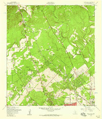
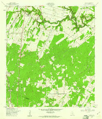 1958 Losoya1961 Print · USGSBexar County south of San Antonio was a landscape of river-valley settlements and rural education during the late 1950s. Genealogists and local historians can locate Our Lady of Mt Carmel Ch, the community of Losoya, and the Thelma Sch along the Missouri Pacific line.3 unique versions available
Showing maps 1-25 of 236
Top cities of Bexar County
- San Antonio historical maps
- Universal City historical maps
- Converse historical maps
- Live Oak historical maps
- Leon Valley historical maps
- Lone Oak historical maps
See more
Frequently asked questions
- What are the different types of historical maps available for Bexar County?
- What is the oldest map of Bexar County?
- Where can I purchase historical maps of Bexar County for my home or office?
- Where can I download high-res historical maps of Bexar County?
- Are there historical topographic maps available for Bexar County?
- Is there historical aerial imagery available for Bexar County?
- Where are historical maps of Bexar County sourced from?