1960s Maps of Borden County, Texas
Explore 9 historic maps of Borden County from the 1960s. These maps offer a rare glimpse into what life looked like during the 1960s — showing old roads, neighborhoods, homes, and landmarks that have changed or disappeared over time.
Whether you're researching your family's past, planning a metal detecting trip, or studying how Borden County's landscape evolved across the 1960s, these high-resolution maps are a powerful tool for exploring the history of this region.
- Focus on a specific era: All maps on this page are from the 1960s, giving you a focused view of this time period.
- See what’s changed: Compare century-old streets, trails, and buildings to today's modern landscape using overlays and satellite layers.
- Research with precision: Use these maps for genealogy, historical research, land use analysis, or educational projects.
- View, download, or print: Maps are fully viewable online in high resolution, and can be downloaded or printed for your own records.
Start exploring Borden County's history through authentic maps from the 1960s. This is your window into the past.
Borden County, TX maps
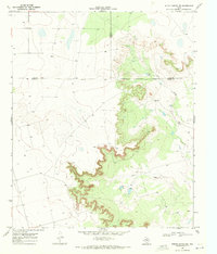
(9)- 1969 Map of Gail NE, 1971 Print
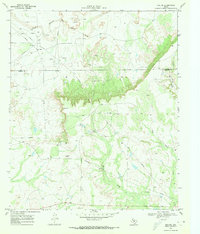 1969 Gail NE1971 Print · USGSBorden and Garza counties in the late sixties show a landscape defined by the oil industry and ranching along the Double Mountain Fork Brazos River. Genealogists and historians can locate the Miller Ranch and trace Pipeline corridors near Sand Creek.2 unique versions available
 - 1969 Map of Arah, 1971 Print
 1969 Arah1971 Print · USGSThe borderlands of Borden and Scurry Counties are captured here in the late sixties, showing a landscape of ranching and early oil exploration. Genealogists can trace the Fluvanna Cem and York Cem or locate the small settlement of Arah.
 - 1969 Map of Beal Hollow, 1971 Print
 1969 Beal Hollow1971 Print · USGSBorden and Garza counties at the close of the 1960s show a landscape shaped by petroleum and ranching. Trace mid-century infrastructure like the Pumping Sta and pipelines alongside family-named landmarks like Beal Hollow and White Tank.
 - 1969 Map of Fluvanna, 1971 Print
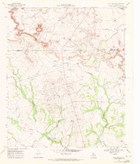
 1969 Fluvanna1971 Print · USGSFluvanna and the high plains of Scurry and Borden counties are captured here in the late sixties as the local oil industry flourished. Researchers can trace the legacy of the Atchison Topeka and Santa Fe and locate the Fluvanna Cem near the Old Railroad Grade.
 - 1969 Map of Indian Canyon NE, 1971 Print
 1969 Indian Canyon NE1971 Print · USGSThe High Plains plateau gives way to the deep canyon breaks of Borden and Garza counties in the late sixties. Trace the ranching landscape around Dennis Ranch or follow the paths of Bull Creek and Salt Draw past early oil wells.
 - 1969 Map of Gail, 1972 Print
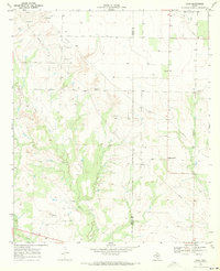
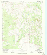
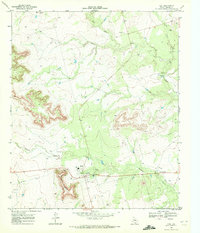 1969 Gail1972 Print · USGSBorden County ranching and civic life come into focus in the late sixties as the community of Town sits at the foot of Gail Mountain. Researchers can trace local roots through the Gail Sch, Cem, and the ranching culture of the Flying D Ranch.
 - 1969 Map of Indian Canyon, 1972 Print
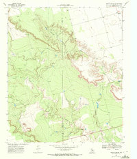 1969 Indian Canyon1972 Print · USGSThe rugged canyons of the West Texas caprock are captured here in the late sixties as the oil industry expanded across the county line. Researchers can trace the winding Outlaw Road and locate remote sites like Mesquite or the Oil Wells tucked into Indian Canyon.
 - 1969 Map of Holloway Canyon, 1972 Print
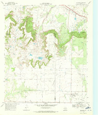
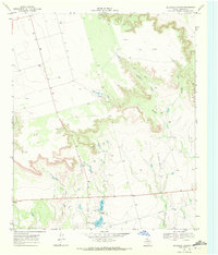 1969 Holloway Canyon1972 Print · USGSBorden County in the late sixties shows a landscape adapted for petroleum and cattle ranching during a period of steady industrial expansion. Genealogists and historians can trace local land use through features like Johnson Tank, the remote Landing Strip, and numerous Oil Wells.
 - 1969 Map of Fivemile Creek, 1972 Print
 1969 Fivemile Creek1972 Print · USGSBorden County rangeland meets the mid-century oil patch in this late 1960s survey of the Texas plains. Trace the early industrial footprint of Oil Wells and Gravel Pits alongside natural landmarks like Five Mile and Bull Creek.
End of results
Showing maps 1-9 of 9
Top cities of Borden County
Frequently asked questions
- What are the different types of historical maps available for Borden County?
- What is the oldest map of Borden County?
- Where can I purchase historical maps of Borden County for my home or office?
- Where can I download high-res historical maps of Borden County?
- Are there historical topographic maps available for Borden County?
- Is there historical aerial imagery available for Borden County?
- Where are historical maps of Borden County sourced from?