
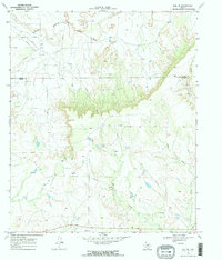
1969 Map of Gail NE
USGS Topo · Published 1971About this map
The Double Mountain Fork Brazos River cuts through the northern reaches of this West Texas landscape, where the high plains break into the canyon country along the Garza Co Borden Co line. Mapping by the U.S. Geological Survey in the late 1960s reveals an environment dominated by energy extraction and ranching, with numerous Oil Wells and a significant Pipeline network spanning the scrubland. Evidence of the local cattle economy is preserved in the fine red dashed lines indicating ranch fences and the presence of the Miller Ranch. Deep drainage features like Red Creek Canyon and East Gavett Creek define the topography, while landmarks such as Miller and various Gravel Pits suggest the localized industrial activity of the era.
Find a feature on this map
11 named features on this map. Tap any name to fly to it.
Don’t see what you’re looking for? This feature index may not catch every label — zoom into the map to look around manually.
Map Details
Editions of this 1969 Gail NE Map
2 editions found
Other maps of this area

1954 · Lubbock
USGS Topo · 1:250,000

1954 · Big Spring
USGS Topo · 1:250,000

1958 · Big Spring
USGS Topo · 1:250,000

1969 · Arah
USGS Topo · 1:24,000

1969 · Beal Hollow
USGS Topo · 1:24,000

1969 · Fluvanna
USGS Topo · 1:24,000

1969 · Gail
USGS Topo · 1:24,000

1969 · Justiceburg
USGS Topo · 1:24,000

1969 · Cooper Creek
USGS Topo · 1:24,000
1969 · Middle Creek
USGS Topo · 1:24,000