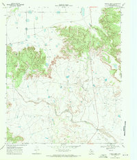
1969 Map of Middle Creek
USGS Topo · Published 1972About this map
The Double Mountain Fork Brazos River snakes across this West Texas landscape, cutting through the high plains of Garza County. Surveyed in the late 1960s, the terrain shows a mix of traditional ranching and modern industrial development. The U Lazy S Ranch occupies a significant portion of the area, centered near Middle Creek. The landscape is etched with oil production infrastructure, including numerous scattered Oil Well sites and a prominent Pipeline. To the south, Salt Creek feeds toward the river, while a Landing Strip and Gravel Pit indicate the logistical and extractive activities of the era. The mapping of selected fence lines across the high ground provides a detailed view of property divisions and land use patterns during this period of the twentieth century.
Find a feature on this map
9 named features on this map. Tap any name to fly to it.
Don’t see what you’re looking for? This feature index may not catch every label — zoom into the map to look around manually.
Map Details
Editions of this 1969 Middle Creek Map
2 editions found
Other maps of this area

1954 · Lubbock
USGS Topo · 1:250,000

1954 · Big Spring
USGS Topo · 1:250,000

1958 · Big Spring
USGS Topo · 1:250,000

1969 · Gail NE
USGS Topo · 1:24,000

1969 · Beal Hollow
USGS Topo · 1:24,000

1969 · Indian Canyon NE
USGS Topo · 1:24,000

1969 · Post East
USGS Topo · 1:24,000

1969 · Grassland SE
USGS Topo · 1:24,000

1969 · Post West
USGS Topo · 1:24,000

1969 · Cooper Creek
USGS Topo · 1:24,000