
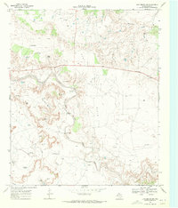
1969 Map of Justiceburg
USGS Topo · Published 1972About this map
Justiceburg sits at a critical junction of transport and industry where the Atchison Topeka and Santa Fe railway cuts across the winding path of the Double Mountain Fork Brazos River. This 1969 survey reveals a landscape deeply defined by petroleum extraction, featuring extensive drilling operations at the Post Oil Field, North Justiceburg Oil Field, and Curt-Roy Oil Field. The terrain north of the river transitions into a dramatic eroded area known as The Badlands, while human activity centers around water management and transit infrastructure.
Find a feature on this map
24 named features on this map. Tap any name to fly to it.
Don’t see what you’re looking for? This feature index may not catch every label — zoom into the map to look around manually.
Map Details
Editions of this 1969 Justiceburg Map
This is the sole edition of this map. No revisions or reprints were ever made.
Other maps of this area

1954 · Lubbock
USGS Topo · 1:250,000

1954 · Big Spring
USGS Topo · 1:250,000

1958 · Big Spring
USGS Topo · 1:250,000

1969 · Cottonwood Creek
USGS Topo · 1:24,000

1969 · Gail NE
USGS Topo · 1:24,000

1969 · Justiceburg SE
USGS Topo · 1:24,000

1969 · Fluvanna
USGS Topo · 1:24,000
1969 · Justiceburg NW
USGS Topo · 1:24,000

1969 · Post East
USGS Topo · 1:24,000

1969 · Cooper Creek
USGS Topo · 1:24,000