1950s Maps of De Kalb, Texas
Explore 6 historic maps of De Kalb from the 1950s. These maps offer a rare glimpse into what life looked like during the 1950s — showing old roads, neighborhoods, homes, and landmarks that have changed or disappeared over time.
Whether you're researching your family's past, planning a metal detecting trip, or studying how De Kalb's landscape evolved across the 1950s, these high-resolution maps are a powerful tool for exploring the history of this region.
- Focus on a specific era: All maps on this page are from the 1950s, giving you a focused view of this time period.
- See what’s changed: Compare century-old streets, trails, and buildings to today's modern landscape using overlays and satellite layers.
- Research with precision: Use these maps for genealogy, historical research, land use analysis, or educational projects.
- View, download, or print: Maps are fully viewable online in high resolution, and can be downloaded or printed for your own records.
Start exploring De Kalb's history through authentic maps from the 1950s. This is your window into the past.
De Kalb, TX maps
(6)- 1950 Map of De Kalb, 1976 Print
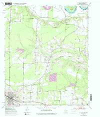 1950 De Kalb1976 Print · USGSBowie County at mid-century shows a landscape of rural schools and family cemeteries clustered around the De Kalb rail corridor. Genealogists can trace local landmarks like Woodman Cem, Bethlehem Sch, and the banks of the Red River.2 unique versions available
 - 1950 Map of Oak Grove, 1976 Print
 1950 Oak Grove1976 Print · USGSBowie County at the midpoint of the century shows a landscape of small rail-side communities and scattered country parishes. Genealogists can trace family footprints near Oak Grove, Garland, and rural landmarks like Gravel Hill Ch or the Garland Cem.
 - 1951 Map of De Kalb
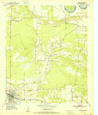 1951 De Kalb1951 Print · USGSBowie County, Texas, was a landscape of small schools and rural churches in the years following the war. Researchers can trace the Texas and Pacific rail line through De Kalb or locate family markers at Woodman Cem and Harrell Cem.
 - 1951 Map of Oak Grove
 1951 Oak Grove1951 Print · USGSBowie County at the dawn of the 1950s shows a landscape of rural communities tied together by the Texas and Pacific rail line. Genealogists can trace family footprints at Mt Pleasant Sch, Garland Cem, and West Bowie Union Ch.
 - 1953 Map of Texarkana, 1964 Print
 1953 Texarkana1964 Print · USGSThe Texas-Arkansas borderlands are captured here in the mid-fifties, during a decade of massive military and hydraulic engineering projects. Genealogists and researchers can locate family landmarks like Old Boston Cem, Siloam Ch, and the vast Red River Arsenal.4 unique versions available
 - 1956 Map of Texarkana
 1956 Texarkana1956 Print · USGSThe Ark-La-Tex borderlands come alive in the mid-fifties, showing the transition from a rail-dependent rural economy to a post-war industrial landscape. Researchers can trace the massive Red River Ordnance Depot and find towns like Talco, Bogata, and Naples.
End of results
Showing maps 1-6 of 6
Top cities near De Kalb
Frequently asked questions
- What are the different types of historical maps available for De Kalb?
- What is the oldest map of De Kalb?
- Where can I purchase historical maps of De Kalb for my home or office?
- Where can I download high-res historical maps of De Kalb?
- Are there historical topographic maps available for De Kalb?
- Is there historical aerial imagery available for De Kalb?
- Where are historical maps of De Kalb sourced from?