
1950 Map of De Kalb
USGS Topo · Published 1976About this map
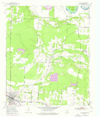
The town of De Kalb serves as the focal point of this mid-century survey, situated along the critical transit corridor of the Texas and Pacific railroad. The landscape transition from the higher ground near the settlement down to the Red River valley in the north reveals a rural network of community landmarks. Local family history is preserved in sites such as Woodman Cem, Harrell Cem, and Harris Cem. The area’s educational and spiritual life is marked by the Bethlehem Sch and Mt Zion Ch, which sit between the winding paths of Holly Creek and Mud Creek. Near the state border, the river forms distinctive features like Billy Hall Bend and Gunn Lake, illustrating how the waterway shaped the boundary between Texas and Oklahoma before modern levee systems altered the floodplains.
Find a feature on this map
21 named features on this map. Tap any name to fly to it.
Don’t see what you’re looking for? This feature index may not catch every label — zoom into the map to look around manually.
Map Details
Editions of this 1950 De Kalb Map
2 editions found
Other maps of this area

1909 · New Boston
USGS Topo · 1:62,500

1930 · Bassett
USGS Topo · 1:62,500

1950 · De Kalb NW
USGS Topo · 1:24,000

1950 · Tom
USGS Topo · 1:24,000

1950 · Oak Grove
USGS Topo · 1:24,000

1951 · De Kalb
USGS Topo · 1:24,000

1951 · De Kalb NW
USGS Topo · 1:24,000

1951 · Tom
USGS Topo · 1:24,000

1951 · Oak Grove
USGS Topo · 1:24,000

1951 · Foreman
USGS Topo · 1:24,000