1970s Maps of Alpine, Texas
Explore 3 historic maps of Alpine from the 1970s. These maps offer a rare glimpse into what life looked like during the 1970s — showing old roads, neighborhoods, homes, and landmarks that have changed or disappeared over time.
Whether you're researching your family's past, planning a metal detecting trip, or studying how Alpine's landscape evolved across the 1970s, these high-resolution maps are a powerful tool for exploring the history of this region.
- Focus on a specific era: All maps on this page are from the 1970s, giving you a focused view of this time period.
- See what’s changed: Compare century-old streets, trails, and buildings to today's modern landscape using overlays and satellite layers.
- Research with precision: Use these maps for genealogy, historical research, land use analysis, or educational projects.
- View, download, or print: Maps are fully viewable online in high resolution, and can be downloaded or printed for your own records.
Start exploring Alpine's history through authentic maps from the 1970s. This is your window into the past.
Alpine, TX maps
(3)- 1972 Map of Alpine North, 1975 Print
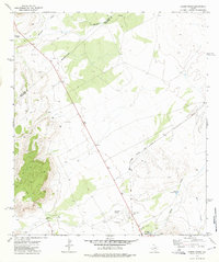 1972 Alpine North1975 Print · USGSThe high desert outskirts of Alpine are captured here in the early seventies, showing a landscape defined by ranching and rail. Genealogists and historians can trace the Atchison Topeka and Santa Fe line or locate the Merriwether Ranch and Municipal Airport.
 - 1972 Map of Alpine South, 1975 Print
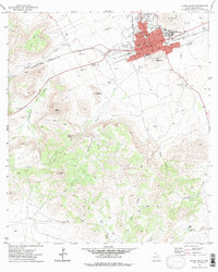 1972 Alpine South1975 Print · USGSThe Trans-Pecos cattle and college town of Alpine is shown in the early seventies, caught between the high desert peaks and its rail-line origins. Genealogists and historians can trace the growth of Sul Ross State University and locate landmarks like Brewster Mem Hosp and the Rodeo Ground.
 - 1973 Map of Fort Stockton, 1974 Print
 1973 Fort Stockton1974 Print · USGSThe Trans-Pecos region of West Texas comes alive in the early seventies, from the desert flats of the Stockton Plateau to the heights of the Davis Mountains. Researchers can trace the legacy of frontier outposts and rail lines through Fort Davis Nat Hist Site, Alpine, and the Southern Pacific RR.
End of results
Showing maps 1-3 of 3
Frequently asked questions
- What are the different types of historical maps available for Alpine?
- What is the oldest map of Alpine?
- Where can I purchase historical maps of Alpine for my home or office?
- Where can I download high-res historical maps of Alpine?
- Are there historical topographic maps available for Alpine?
- Is there historical aerial imagery available for Alpine?
- Where are historical maps of Alpine sourced from?