1920s Maps of Brownwood, Texas
Explore 2 historic maps of Brownwood from the 1920s. These maps offer a rare glimpse into what life looked like during the 1920s — showing old roads, neighborhoods, homes, and landmarks that have changed or disappeared over time.
Whether you're researching your family's past, planning a metal detecting trip, or studying how Brownwood's landscape evolved across the 1920s, these high-resolution maps are a powerful tool for exploring the history of this region.
- Focus on a specific era: All maps on this page are from the 1920s, giving you a focused view of this time period.
- See what’s changed: Compare century-old streets, trails, and buildings to today's modern landscape using overlays and satellite layers.
- Research with precision: Use these maps for genealogy, historical research, land use analysis, or educational projects.
- View, download, or print: Maps are fully viewable online in high resolution, and can be downloaded or printed for your own records.
Start exploring Brownwood's history through authentic maps from the 1920s. This is your window into the past.
Brownwood, TX maps
(2)- 1925 Map of Brownwood 3-b
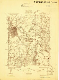 1925 Brownwood 3-b1925 Print · USGSBrownwood flourished as a Texas railroad junction in the mid-1920s, its growth shaped by two major rail lines and the winding Pecan Bayou. Genealogists and local historians can trace rural school districts like Woodland Heights School or find the Steppes Creek Church along the old Goldthwaite Road.
 - 1928 Map of Zephyr
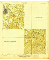 1928 Zephyr1928 Print · USGSCentral Texas ranching and rail activity are on full display in the mid-1920s as Brownwood expands toward the southeast. Trace ancestral connections at Steppes Creek Church or locate vanished local landmarks like Slighdale School and Adams Crossing.
End of results
Showing maps 1-2 of 2
Top cities near Brownwood
Top neighborhoods of Brownwood
Frequently asked questions
- What are the different types of historical maps available for Brownwood?
- What is the oldest map of Brownwood?
- Where can I purchase historical maps of Brownwood for my home or office?
- Where can I download high-res historical maps of Brownwood?
- Are there historical topographic maps available for Brownwood?
- Is there historical aerial imagery available for Brownwood?
- Where are historical maps of Brownwood sourced from?