1900s (20th Century) Maps of Lockhart, Texas
Explore 10 historic maps of Lockhart from the 1900s (20th Century). These maps offer a rare glimpse into what life looked like during the 1900s — showing old roads, neighborhoods, homes, and landmarks that have changed or disappeared over time.
Whether you're researching your family's past, planning a metal detecting trip, or studying how Lockhart's landscape evolved across the 1900s, these high-resolution maps are a powerful tool for exploring the history of this region.
- Focus on a specific era: All maps on this page are from the 1900s, giving you a focused view of this time period.
- See what’s changed: Compare century-old streets, trails, and buildings to today's modern landscape using overlays and satellite layers.
- Research with precision: Use these maps for genealogy, historical research, land use analysis, or educational projects.
- View, download, or print: Maps are fully viewable online in high resolution, and can be downloaded or printed for your own records.
Start exploring Lockhart's history through authentic maps from the 1900s. This is your window into the past.
Lockhart, TX maps
(10)- 1911 Map of San Marcos
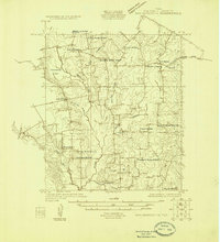
 1911 San Marcos1911 Print · USGSCentral Texas at the peak of the railroad era shows a landscape of small farming communities and country schools. Genealogists can trace family footprints across Comanche Flat or locate long-gone sites like Highpoint School and Bethany Church.2 unique versions available
 - 1919 Map of San Marcos
 1919 San Marcos1919 Print · USGSTexas at the close of the Great War was a landscape of river-fed farms and emerging rail corridors between San Marcos and Lockhart. Genealogists can trace family footprints through numerous rural landmarks like Clark Chapel, High Prairie School, and Larremore.
 - 1925 Map of San Marcos 1-d
 1925 San Marcos 1-d1925 Print · USGSCaldwell County's rural farming communities are captured here in the mid-twenties, showcasing a landscape defined by small schools and country churches. Genealogists can trace family footprints near Lovely Plant School, Mc Mahan, and Clear Fork Church.
 - 1930 Map of Lockhart
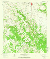
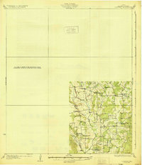 1930 Lockhart1930 Print · USGSCaldwell County is captured here in the mid-twenties, showing a landscape defined by small farming communities and a high density of rural schoolhouses. Researchers can trace family-named landmarks like McMahan and Seawillow or locate community centers such as Tilmon Sch and Clark Chapel.2 unique versions available
 - 1953 Map of Seguin, 1965 Print
 1953 Seguin1965 Print · USGSSouth Texas in the early fifties shows a thriving river-and-rail economy across the Guadalupe and Colorado basins. Genealogists and historians can trace rail routes like the Southern Pacific through Seguin, locate oil wells, or find the Gary AAF near San Marcos.4 unique versions available
 - 1958 Map of Seguin
 1958 Seguin1958 Print · USGSSouth Texas in the late fifties was a network of river-valley settlements and active oilfields tied together by major rail lines. Genealogists and historians can trace family-named sites across Rabb Prairie, locate the Behring Store, or follow the Southern Pacific through Schulenburg.
 - 1963 Map of Lockhart North, 1966 Print
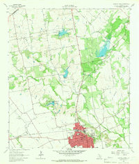 1963 Lockhart North1966 Print · USGSCaldwell County's landscape in the early sixties showcases a growing Lockhart integrated with a sophisticated network of flood control reservoirs and rail lines. Family historians can trace rural roots through Ohlendorf Cem, Polonia Cem, and the Carver High Sch.3 unique versions available
 - 1963 Map of McMahan, 1966 Print
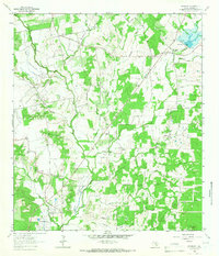 1963 McMahan1966 Print · USGSCaldwell County’s rural landscape is captured here in the 1960s, showing a region shaped by petroleum production and small farming communities. Researchers can trace family roots at Clark Chapel Cem or Blackwell Cem and locate vanished sites in Seawillow and Brownsboro.2 unique versions available
 - 1964 Map of Lockhart South, 1966 Print
 1964 Lockhart South1966 Print · USGSCaldwell County's landscape in the mid-sixties reveals the southern growth of Lockhart and the quiet life of the surrounding ranchland. Local researchers can trace family roots at Popps Cem or Harrison Cem and locate the Old Railroad Grade near Joliet.3 unique versions available
 - 1985 Map of Seguin, 1986 Print
 1985 Seguin1986 Print · USGSCentral Texas in the mid-1980s is defined by its vital oil industry and the crossroads of major interstate and rail networks. Genealogists and historians can trace the development of Luling Oil Field, identify the site of Old Flatonia, or locate family landmarks near St James and Palmetto State Park.2 unique versions available
End of results
Showing maps 1-10 of 10
Top cities near Lockhart
- Austin historical maps
- San Marcos historical maps
- Seguin historical maps
- Kyle historical maps
- Buda historical maps
- Luling historical maps
See more
Top neighborhoods of Lockhart
Frequently asked questions
- What are the different types of historical maps available for Lockhart?
- What is the oldest map of Lockhart?
- Where can I purchase historical maps of Lockhart for my home or office?
- Where can I download high-res historical maps of Lockhart?
- Are there historical topographic maps available for Lockhart?
- Is there historical aerial imagery available for Lockhart?
- Where are historical maps of Lockhart sourced from?