1950s Maps of Cameron County, Texas
Explore 35 historic maps of Cameron County from the 1950s. These maps offer a rare glimpse into what life looked like during the 1950s — showing old roads, neighborhoods, homes, and landmarks that have changed or disappeared over time.
Whether you're researching your family's past, planning a metal detecting trip, or studying how Cameron County's landscape evolved across the 1950s, these high-resolution maps are a powerful tool for exploring the history of this region.
- Focus on a specific era: All maps on this page are from the 1950s, giving you a focused view of this time period.
- See what’s changed: Compare century-old streets, trails, and buildings to today's modern landscape using overlays and satellite layers.
- Research with precision: Use these maps for genealogy, historical research, land use analysis, or educational projects.
- View, download, or print: Maps are fully viewable online in high resolution, and can be downloaded or printed for your own records.
Start exploring Cameron County's history through authentic maps from the 1950s. This is your window into the past.
Cameron County, TX maps
(35)- 1952 Map of Green Island, 1953 Print
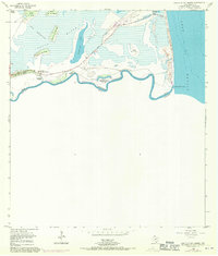
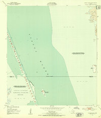 1952 Green Island1953 Print · USGSThe South Texas coast comes alive in the early 1950s, showing the intersection of wildlife conservation and maritime commerce. Trace the dredging of the Intracoastal Waterway past the Green Island (Bird Sanctuary) and the wild Shifting Sand Dunes of Padre Island.2 unique versions available
 - 1952 Map of North Of Port Isabel NW, 1953 Print
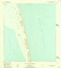
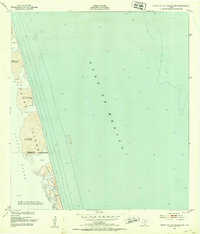 1952 North Of Port Isabel NW1953 Print · USGSCoastal Texas was still a wild frontier of drifting dunes and shallow lagoons in the early fifties. Genealogists and historians can trace the small settlement of Camwill and landmarks like the Negro station among the Shifting sand dunes of Padre Island.2 unique versions available
 - 1952 Map of Hawk Island, 1953 Print
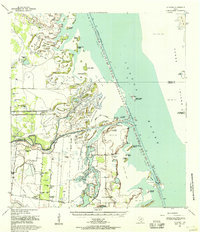
 1952 Hawk Island1953 Print · USGSThe South Texas coast comes alive in the early 1950s where the brushland meets the Laguna Madre. Local history researchers can trace the ranching life through named sites like Loma Alta Well and the waters of the Arroyo Colorado.3 unique versions available
 - 1953 Map of Brownsville
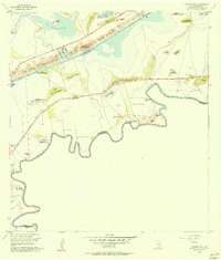
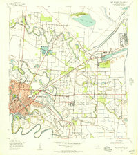
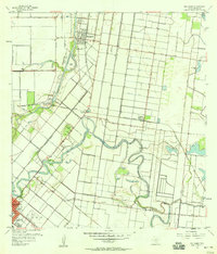
 1953 Brownsville1953 Print · USGSSouth Texas ranchlands and the Lower Rio Grande Valley are captured here in the early fifties as the region's irrigation and shipping networks expanded. Genealogists and historians can trace family landholdings like Tecolote Ranch or follow the route of the St Louis Brownsville and Mexico rail line through Sebastian and Yturria.
 - 1954 Map of Three Islands, 1957 Print
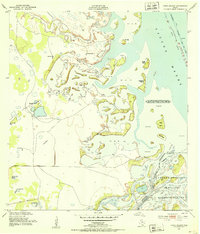
 1954 Three Islands1957 Print · USGSThe Cameron County coast appears in the mid-1950s as a landscape of dredging projects and protected wildlife habitat. Genealogists and historians can trace family-named coastal features like Rincon Buena Vista, Hobnail Island, and the historic Townsite Point.3 unique versions available
 - 1955 Map of Mouth Of Rio Grande
 1955 Mouth Of Rio Grande1955 Print · USGSThe Texas-Mexico borderlands meet the sea in this mid-century survey of the Rio Grande's final reach. You can trace the international boundary through Tarpon Bend and locate coastal landmarks like Boca Chica Beach and the Mesa del Gavilan.2 unique versions available
 - 1955 Map of Mouth Of Rio Grande, 1956 Print
 1955 Mouth Of Rio Grande1956 Print · USGSThe Texas-Mexico borderlands meet the Gulf in the mid-1950s, showing a landscape of shifting river banks and coastal lomas. Trace the route of the Boca Chica Highway to the coast or locate the Tidewater Dam and Steil-Lind Banco No 128.
 - 1955 Map of Palmito Hill, 1956 Print
 1955 Palmito Hill1956 Print · USGSThe Texas coast near the mouth of the Rio Grande is shown here in the mid-fifties, centered on the site of the last battle of the Civil War. Researchers can trace the legacy of old cattle operations at Old Palmito Ranch or locate the Battle of Palmito Hill historical monument.3 unique versions available
 - 1955 Map of Southmost, 1956 Print
 1955 Southmost1956 Print · USGSThe Rio Grande meanders through southernmost Texas in the mid-1950s, defining a landscape of agricultural plantations and international bancos. Genealogists and historians can trace family lands at Brulay Plantation, Southmost Ranch, and Southmost Cem.2 unique versions available
 - 1955 Map of Port Isabel NW, 1956 Print
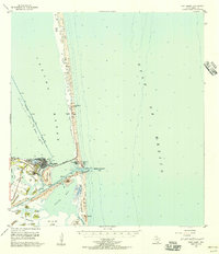
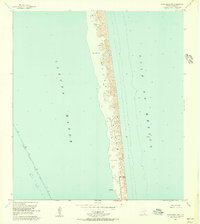 1955 Port Isabel NW1956 Print · USGSCoastal Cameron County comes into focus in the mid-1950s, showing the early infrastructure of Padre Island. Researchers can trace the original shoreline at Long Point and find markers for navigation like the Intracoastal Waterway and Andy Bowie Park.4 unique versions available
 - 1955 Map of La Leona, 1957 Print
 1955 La Leona1957 Print · USGSCoastal Texas ranching comes to life in the mid-fifties along the Laguna Madre. Researchers can trace the layout of traditional family lands including Los Coyotes Ranch and Rancho Nuevo as they appeared before modern coastal changes.2 unique versions available
 - 1955 Map of Los Fresnos, 1957 Print
 1955 Los Fresnos1957 Print · USGSCoastal Cameron County in the mid-1950s shows a landscape transitioning between its martial history and modern agricultural expansion. Trace the Palo Alto Battlefield and find local landmarks like Wardner Ranch, Charco Honda, and Los Fresnos Sch.3 unique versions available
 - 1955 Map of Laguna Vista, 1957 Print
 1955 Laguna Vista1957 Print · USGSCoastal Cameron County in the mid-fifties is defined by the winding lomas and tidal waters of the Laguna Madre. Trace local history through the early footprints of Laguna Vista and Bayside, or locate forgotten paths like La Aura Crossing.4 unique versions available
 - 1955 Map of Port Isabel, 1957 Print
 1955 Port Isabel1957 Print · USGSCoastal Cameron County comes into focus in the mid-fifties, just as the barrier islands began to develop for tourism. Trace the early Queen Isabella Causeway, the Missouri Pacific Railroad terminus, and family-named lomas like Loma Ochoa.
 - 1955 Map of North Of Port Isabel, 1957 Print
 1955 North Of Port Isabel1957 Print · USGSThe South Texas coast in the mid-1950s remained a landscape of moving earth and isolated outposts. Trace the early shoreline of Padre Island and locate remote named points like Los Tanques and Los Bancos de en Medio.
 - 1955 Map of La Leona, 1957 Print
 1955 La Leona1957 Print · USGSIn the mid-1950s, the South Texas coastline was a patchwork of cattle operations and tidal wetlands. Trace family roots at La Leona Cem or locate historical holdings like Miradores Ranch and Totman Ranch along the Arroyo Colorado.4 unique versions available
 - 1955 Map of East Brownsville, 1957 Print
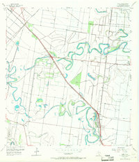
 1955 East Brownsville1957 Print · USGSMid-century Brownsville and the Rio Grande frontier are documented here during a period of rapid industrial and aerial growth. Genealogists can trace family footprints at Buena Vista Cemetery and Santa Rosalia Cem or locate local landmarks like Southmost College and the Old Fort Brown Reservation.6 unique versions available
 - 1955 Map of North Of Port Isabel SW, 1957 Print
 1955 North Of Port Isabel SW1957 Print · USGSThe South Texas coast in the mid-fifties is captured here as a landscape of wind-swept terrain and early industry. Trace the natural shoreline of Padre Island and identify landmarks like Los Tanques and a remote coastal Oil Well.3 unique versions available
 - 1955 Map of Port Isabel, 1957 Print
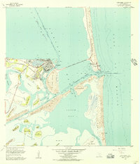 1955 Port Isabel1957 Print · USGSPort Isabel and the surrounding barrier islands are captured in the mid-fifties as the region developed into a vital maritime and industrial hub. Trace the early layout of Isla Blanca Park, the path of the Queen Isabella Causeway, and numerous coastal lomas like Loma del Mesquite.4 unique versions available
 - 1955 Map of La Coma, 1957 Print
 1955 La Coma1957 Print · USGSAlong the South Texas coast in the mid-fifties, this landscape shows the intersection of ranching and conservation. Genealogists can trace family footprints at Buena Vista Ranch or Holly Beach, and locate the Buena Vista Sch and a local Cem.3 unique versions available
 - 1955 Map of Fort Brown, 1958 Print
 1955 Fort Brown1958 Print · USGSBrownsville and the lower Rio Grande valley are captured here in the mid-fifties as the region's irrigation and shipping networks matured. Trace ancestral roots at the Buena Vista Cem or explore military history at Fort Brown and the Palmito Hill Battlefield.
 - 1956 Map of Rio Hondo
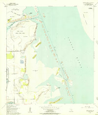
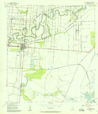
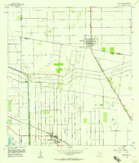
 1956 Rio Hondo1956 Print · USGSCoastal South Texas is shown here at mid-century, where complex irrigation networks and rail lines defined the landscape near the Gulf. Genealogists and historians can trace the foundations of San Benito and Rio Hondo, or find local landmarks like the Monte Meta Cemetery and Las Yescas Sch.3 unique versions available
 - 1956 Map of Laguna Atascosa, 1957 Print
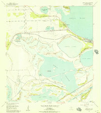
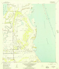
 1956 Laguna Atascosa1957 Print · USGSIn the mid-1950s, the coastal prairies of Cameron County were defined by the expanding Laguna Atascosa National Wildlife Refuge and the deep delta resacas. Genealogists and local historians can trace family-named sites like La Tina Ranch, La Tina Cem, and the settlement of Bayview.
 - 1956 Map of Olmito, 1957 Print
 1956 Olmito1957 Print · USGSIn the mid-1950s, the Cameron County landscape was a complex network of ancient resacas and modern irrigation canals. Trace family-named landmarks and settlements along the Missouri Pacific rail line, including Russeltown, Villa Cavazos, and Olmito Lake.5 unique versions available
 - 1956 Map of Santa Rosa, 1958 Print
 1956 Santa Rosa1958 Print · USGSThe Rio Grande Valley's irrigation and rail network are captured here in the mid-1950s as agriculture reshaped the Cameron County landscape. Researchers can trace historic cemeteries like San Rafael Cem and follow the path of the North Floodway.3 unique versions available
Showing maps 1-25 of 35
Top cities of Cameron County
- Brownsville historical maps
- Harlingen historical maps
- San Benito historical maps
- La Feria historical maps
- Cameron Park historical maps
- Los Fresnos historical maps
See more
Frequently asked questions
- What are the different types of historical maps available for Cameron County?
- What is the oldest map of Cameron County?
- Where can I purchase historical maps of Cameron County for my home or office?
- Where can I download high-res historical maps of Cameron County?
- Are there historical topographic maps available for Cameron County?
- Is there historical aerial imagery available for Cameron County?
- Where are historical maps of Cameron County sourced from?