2020s Maps of Brownsville, Texas
Explore 10 historic maps of Brownsville from the 2020s. These maps offer a rare glimpse into what life looked like during the 2020s — showing old roads, neighborhoods, homes, and landmarks that have changed or disappeared over time.
Whether you're researching your family's past, planning a metal detecting trip, or studying how Brownsville's landscape evolved across the 2020s, these high-resolution maps are a powerful tool for exploring the history of this region.
- Focus on a specific era: All maps on this page are from the 2020s, giving you a focused view of this time period.
- See what’s changed: Compare century-old streets, trails, and buildings to today's modern landscape using overlays and satellite layers.
- Research with precision: Use these maps for genealogy, historical research, land use analysis, or educational projects.
- View, download, or print: Maps are fully viewable online in high resolution, and can be downloaded or printed for your own records.
Start exploring Brownsville's history through authentic maps from the 2020s. This is your window into the past.
Brownsville, TX maps
(10)- 2022 Map of Laguna Vista, 2022 Print
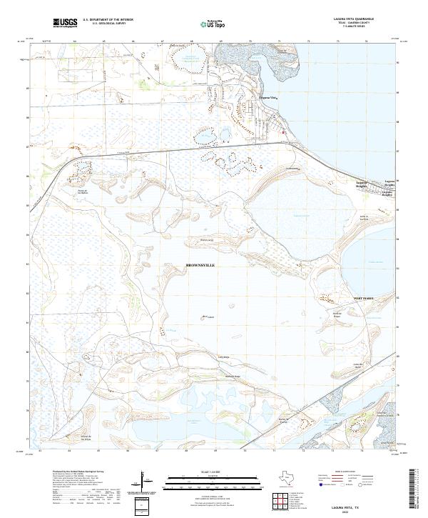 2022 Laguna Vista2022 Print · USGSCoastal Cameron County comes into focus in the early 2020s, showing the residential expansion of Laguna Vista and Laguna Heights against the Gulf wetlands. Trace the maritime geography of the Brownsville Ship Channel and the shores of San Martin Lake.
 - 2022 Map of Los Fresnos, 2022 Print
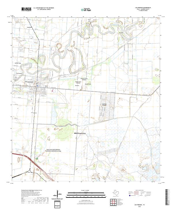 2022 Los Fresnos2022 Print · USGSCameron County comes into focus in this contemporary record of its unique resaca-laced landscape and historic battlegrounds. Genealogists and historians can trace local roots at Los Cuates Cem or explore the hallowed ground of Palo Alto Battlefield.
 - 2022 Map of Rio Hondo, 2022 Print
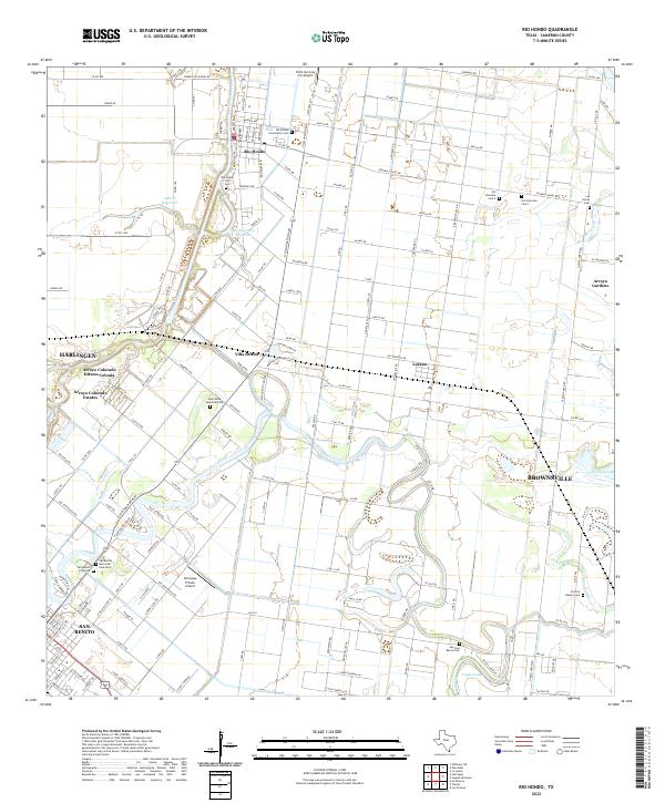 2022 Rio Hondo2022 Print · USGSCameron County's agricultural heartland is documented here in the early twenty-first century as irrigation canals and winding waterways define the landscape. Genealogists and local historians can trace family roots through numerous sites like Mont Meta Memorial Park, Villa del Sol, and the San Jose Ranch Cem.
 - 2022 Map of Olmito, 2022 Print
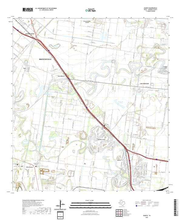 2022 Olmito2022 Print · USGSThe Lower Rio Grande Valley's unique resaca landscape is captured here in the early twenty-first century. Genealogists can trace family sites at San Pedro Cem and Alejandro Garza Memorial Cem or explore the growth of Rancho Viejo.
 - 2022 Map of La Paloma, 2022 Print
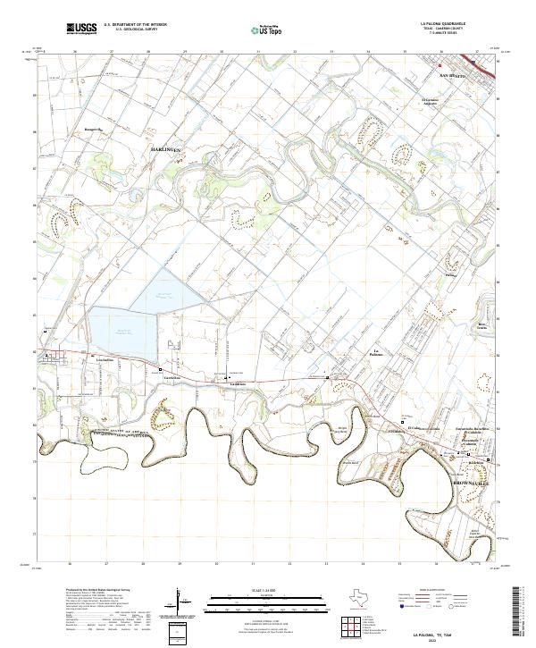 2022 La Paloma2022 Print · USGSThe Rio Grande Valley near the border at the start of the 2020s shows a complex landscape of irrigation and traditional settlements. Genealogists can trace family heritage through numerous rural burial sites like Zepeda Cem, Landrum Cem, and Aguilar Cem.
 - 2022 Map of Palmito Hill, 2022 Print
 2022 Palmito Hill2022 Print · USGSThe Texas coast near the mouth of the river appears here in the early twenty-first century, showing the intersection of international borders and maritime industry. Genealogists and historians can locate the Palmito Hill Cem and trace the many named hills like Loma del Muerto and Loma Tia Alejos.
 - 2022 Map of Southmost, 2022 Print
 2022 Southmost2022 Print · USGSThe southern reaches of Cameron County meet the winding river border in the early twenty-first century. Genealogists and local historians can trace family sites like Brulay Cem and the small settlement of South Point along the banks of the Rio Grande.
 - 2022 Map of East Brownsville, 2022 Print
 2022 East Brownsville2022 Print · USGSBrownsville and the international border come into sharp focus in this recent survey of the Rio Grande delta. Researchers can trace local heritage through the Cameron County Courthouse, Santa Rosalia Cem, and the maritime industry of the Brownsville Ship Channel.
 - 2022 Map of La Coma, 2022 Print
 2022 La Coma2022 Print · USGSThe Texas Gulf Coast near Brownsville is captured in the early 2020s, showing the intersection of conservation and coastal development. Researchers can trace the boundaries of the Laguna Atascosa Refuge, locate the Laguna Atascosa Cem, and explore the shoreline from Stover Point to Laguna Vista.
 - 2023 Map of West Brownsville, 2023 Print
 2023 West Brownsville2023 Print · USGSThe Texas-Mexico borderlands come into focus in this modern era, showing the intricate bends of the Rio Grande and the communities along its banks. Genealogists can trace family heritage through numerous small burial sites like La Muralla Cem and Raul Cavazos Cem near San Pedro.
End of results
Showing maps 1-10 of 10
Top cities near Brownsville
- Harlingen historical maps
- San Benito historical maps
- Cameron Park historical maps
- Los Fresnos historical maps
- Port Isabel historical maps
- Laguna Vista historical maps
See more
Top neighborhoods of Brownsville
- 21 Subdivision Colonia historical maps
- Stewart Colonia historical maps
- Barrios Colonia historical maps
- Cielito Lindo Colonia historical maps
- Jaime Lake Colonia historical maps
- Carretas Crossing historical maps
See more
Frequently asked questions
- What are the different types of historical maps available for Brownsville?
- What is the oldest map of Brownsville?
- Where can I purchase historical maps of Brownsville for my home or office?
- Where can I download high-res historical maps of Brownsville?
- Are there historical topographic maps available for Brownsville?
- Is there historical aerial imagery available for Brownsville?
- Where are historical maps of Brownsville sourced from?