1920s Maps of Brownsville, Texas
Explore 5 historic maps of Brownsville from the 1920s. These maps offer a rare glimpse into what life looked like during the 1920s — showing old roads, neighborhoods, homes, and landmarks that have changed or disappeared over time.
Whether you're researching your family's past, planning a metal detecting trip, or studying how Brownsville's landscape evolved across the 1920s, these high-resolution maps are a powerful tool for exploring the history of this region.
- Focus on a specific era: All maps on this page are from the 1920s, giving you a focused view of this time period.
- See what’s changed: Compare century-old streets, trails, and buildings to today's modern landscape using overlays and satellite layers.
- Research with precision: Use these maps for genealogy, historical research, land use analysis, or educational projects.
- View, download, or print: Maps are fully viewable online in high resolution, and can be downloaded or printed for your own records.
Start exploring Brownsville's history through authentic maps from the 1920s. This is your window into the past.
Brownsville, TX maps
(5)- 1929 Map of Rio Hondo
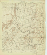 1929 Rio Hondo1929 Print · USGSCoastal South Texas is captured here in the late twenties, showing the intricate water systems and rail lines of the Lower Rio Grande Valley. Genealogists and historians can trace local landmarks like Rio Hondo, the Mexican Christian Ch, and the San Jose Sch.
 - 1929 Map of La Coma
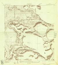
 1929 La Coma1929 Print · USGSThe Texas coast near Laguna Madre comes into focus in the late twenties, showing the intricate resaca systems of the Rio Grande delta. Trace early ranching and rail history through La Coma Ranch, the settlement of Abney, and the San Benito and Rio Grande Valley line.
 - 1929 Map of Palmito Hill
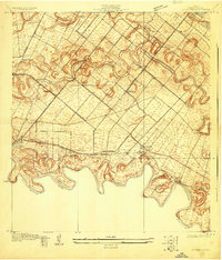
 1929 Palmito Hill1929 Print · USGSThe southern tip of Texas meets the gulf in the late 1920s, where the winding river forms the border with Tamaulipas. Researchers can trace the early road network and remote outposts like Palmito Ranch, Los Sauces Ranch, and the Boca Chica Highway.
 - 1929 Map of Laguna Vista
 1929 Laguna Vista1929 Print · USGSThe Cameron County coastline in the late twenties is defined by a maze of lagoons and ridges as the region began to modernize. Trace early transit routes like Vara Crossing and the Rio Grande Valley RR near Laguna Vista.
 - 1929 Map of La Paloma
 1929 La Paloma1929 Print · USGSCoastal South Texas is depicted here in the late twenties as the agricultural valley relied on the irrigation of the old river resacas. Genealogists and historians can trace the early rail stops and schools like Rangerville Sch, Carricitos Siding, and the riverside village of La Paloma.
End of results
Showing maps 1-5 of 5
Top cities near Brownsville
- Harlingen historical maps
- San Benito historical maps
- Cameron Park historical maps
- Los Fresnos historical maps
- Port Isabel historical maps
- Laguna Vista historical maps
See more
Top neighborhoods of Brownsville
- 21 Subdivision Colonia historical maps
- Stewart Colonia historical maps
- Barrios Colonia historical maps
- Cielito Lindo Colonia historical maps
- Jaime Lake Colonia historical maps
- Carretas Crossing historical maps
See more
Frequently asked questions
- What are the different types of historical maps available for Brownsville?
- What is the oldest map of Brownsville?
- Where can I purchase historical maps of Brownsville for my home or office?
- Where can I download high-res historical maps of Brownsville?
- Are there historical topographic maps available for Brownsville?
- Is there historical aerial imagery available for Brownsville?
- Where are historical maps of Brownsville sourced from?