1950s Maps of Brownsville, Texas
Explore 15 historic maps of Brownsville from the 1950s. These maps offer a rare glimpse into what life looked like during the 1950s — showing old roads, neighborhoods, homes, and landmarks that have changed or disappeared over time.
Whether you're researching your family's past, planning a metal detecting trip, or studying how Brownsville's landscape evolved across the 1950s, these high-resolution maps are a powerful tool for exploring the history of this region.
- Focus on a specific era: All maps on this page are from the 1950s, giving you a focused view of this time period.
- See what’s changed: Compare century-old streets, trails, and buildings to today's modern landscape using overlays and satellite layers.
- Research with precision: Use these maps for genealogy, historical research, land use analysis, or educational projects.
- View, download, or print: Maps are fully viewable online in high resolution, and can be downloaded or printed for your own records.
Start exploring Brownsville's history through authentic maps from the 1950s. This is your window into the past.
Brownsville, TX maps
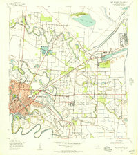
(15)- 1953 Map of Brownsville
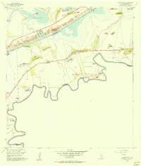
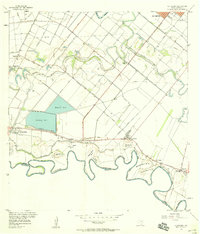
 1953 Brownsville1953 Print · USGSSouth Texas ranchlands and the Lower Rio Grande Valley are captured here in the early fifties as the region's irrigation and shipping networks expanded. Genealogists and historians can trace family landholdings like Tecolote Ranch or follow the route of the St Louis Brownsville and Mexico rail line through Sebastian and Yturria.
 - 1955 Map of Palmito Hill, 1956 Print
 1955 Palmito Hill1956 Print · USGSThe Texas coast near the mouth of the Rio Grande is shown here in the mid-fifties, centered on the site of the last battle of the Civil War. Researchers can trace the legacy of old cattle operations at Old Palmito Ranch or locate the Battle of Palmito Hill historical monument.3 unique versions available
 - 1955 Map of Southmost, 1956 Print
 1955 Southmost1956 Print · USGSThe Rio Grande meanders through southernmost Texas in the mid-1950s, defining a landscape of agricultural plantations and international bancos. Genealogists and historians can trace family lands at Brulay Plantation, Southmost Ranch, and Southmost Cem.2 unique versions available
 - 1955 Map of Los Fresnos, 1957 Print
 1955 Los Fresnos1957 Print · USGSCoastal Cameron County in the mid-1950s shows a landscape transitioning between its martial history and modern agricultural expansion. Trace the Palo Alto Battlefield and find local landmarks like Wardner Ranch, Charco Honda, and Los Fresnos Sch.3 unique versions available
 - 1955 Map of Laguna Vista, 1957 Print
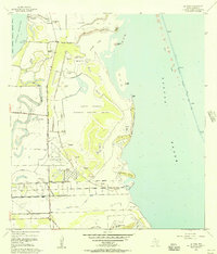
 1955 Laguna Vista1957 Print · USGSCoastal Cameron County in the mid-fifties is defined by the winding lomas and tidal waters of the Laguna Madre. Trace local history through the early footprints of Laguna Vista and Bayside, or locate forgotten paths like La Aura Crossing.4 unique versions available
 - 1955 Map of East Brownsville, 1957 Print
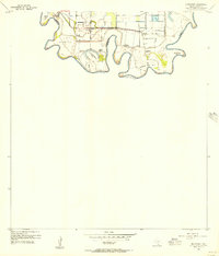
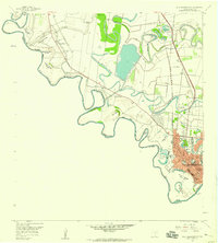
 1955 East Brownsville1957 Print · USGSMid-century Brownsville and the Rio Grande frontier are documented here during a period of rapid industrial and aerial growth. Genealogists can trace family footprints at Buena Vista Cemetery and Santa Rosalia Cem or locate local landmarks like Southmost College and the Old Fort Brown Reservation.6 unique versions available
 - 1955 Map of La Coma, 1957 Print
 1955 La Coma1957 Print · USGSAlong the South Texas coast in the mid-fifties, this landscape shows the intersection of ranching and conservation. Genealogists can trace family footprints at Buena Vista Ranch or Holly Beach, and locate the Buena Vista Sch and a local Cem.3 unique versions available
 - 1955 Map of Fort Brown, 1958 Print
 1955 Fort Brown1958 Print · USGSBrownsville and the lower Rio Grande valley are captured here in the mid-fifties as the region's irrigation and shipping networks matured. Trace ancestral roots at the Buena Vista Cem or explore military history at Fort Brown and the Palmito Hill Battlefield.
 - 1956 Map of Rio Hondo
 1956 Rio Hondo1956 Print · USGSCoastal South Texas is shown here at mid-century, where complex irrigation networks and rail lines defined the landscape near the Gulf. Genealogists and historians can trace the foundations of San Benito and Rio Hondo, or find local landmarks like the Monte Meta Cemetery and Las Yescas Sch.3 unique versions available
 - 1956 Map of Olmito, 1957 Print
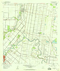
 1956 Olmito1957 Print · USGSIn the mid-1950s, the Cameron County landscape was a complex network of ancient resacas and modern irrigation canals. Trace family-named landmarks and settlements along the Missouri Pacific rail line, including Russeltown, Villa Cavazos, and Olmito Lake.5 unique versions available
 - 1956 Map of La Paloma, 1958 Print
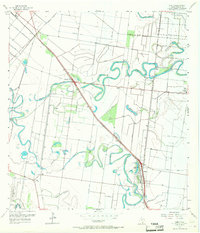
 1956 La Paloma1958 Print · USGSThe Lower Rio Grande Valley in the mid-fifties shows a landscape of intricate irrigation and river-border settlements. Genealogists can trace family footprints near Rangerville, El Calaboz, and the river bends at Esparza-Vera Bend.3 unique versions available
 - 1956 Map of West Brownsville, 1959 Print
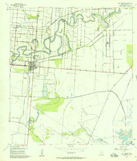
 1956 West Brownsville1959 Print · USGSThe Texas-Mexico borderlands come alive in the late fifties as the Rio Grande winds past Brownsville and its surrounding agricultural bancos. Trace the winding Resaca de la Palma or locate regional landmarks like Mauldin Airport and the International Bridge.3 unique versions available
 - 1956 Map of Los Fresnos, 1959 Print
 1956 Los Fresnos1959 Print · USGSCoastal Cameron County in the mid-fifties is a landscape of ancient river channels and historic ranchlands stretching toward the Laguna Madre. Researchers can trace the Palo Alto Battlefield, local Soldiers Cem, and ranching outposts like La Tina Ranch.
 - 1956 Map of Brownsville, 1969 Print
 1956 Brownsville1969 Print · USGSThe Texas-Mexico borderlands and the Gulf coast come alive in this mid-century survey of the Rio Grande Valley. Genealogists and historians can trace the reach of the Missouri Pacific rail lines through citrus country to schools like Las Yescas and Palm Grove.2 unique versions available
 - 1956 Map of Port Isabel, 1983 Print
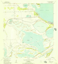
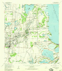
 1956 Port Isabel1983 Print · USGSCoastal Texas and the Rio Grande Valley are shown here in the mid-twentieth century as the region balanced intensive agriculture with maritime trade. Researchers can trace historic rail lines like the SOUTHERN PACIFIC and locate rural landmarks such as Las Yescas Sch or the Armstrong Ranch.
End of results
Showing maps 1-15 of 15
Top cities near Brownsville
- Harlingen historical maps
- San Benito historical maps
- Cameron Park historical maps
- Los Fresnos historical maps
- Port Isabel historical maps
- Laguna Vista historical maps
See more
Top neighborhoods of Brownsville
- 21 Subdivision Colonia historical maps
- Stewart Colonia historical maps
- Barrios Colonia historical maps
- Cielito Lindo Colonia historical maps
- Jaime Lake Colonia historical maps
- Carretas Crossing historical maps
See more
Frequently asked questions
- What are the different types of historical maps available for Brownsville?
- What is the oldest map of Brownsville?
- Where can I purchase historical maps of Brownsville for my home or office?
- Where can I download high-res historical maps of Brownsville?
- Are there historical topographic maps available for Brownsville?
- Is there historical aerial imagery available for Brownsville?
- Where are historical maps of Brownsville sourced from?